Free email delivery
Please sign up for email delivery in the subscription area to the right.
No salesman will call, at least not from us. Maybe from someone else.
Loons and other birds: Malibu Lagoon: 26 July 2026

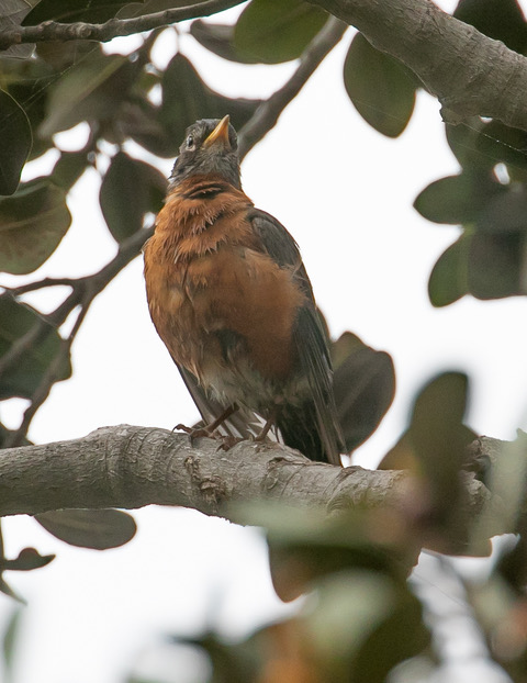
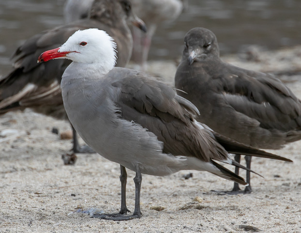
I wouldn’t want to wake up with this staring at me.
[By Chuck Almdale; photos by Femi Faminu, Ray Juncosa, Chris Tosdevin & Kathleen Waldron]
I could tell the surf was up as soon as I turned onto PCH from Malibu Canyon Road. Not because I could see it, but by the cars filling both sides of the road near the entrance to the lagoon. Only late-arriving surfers pay the parking fee, which can run high if you stay long.
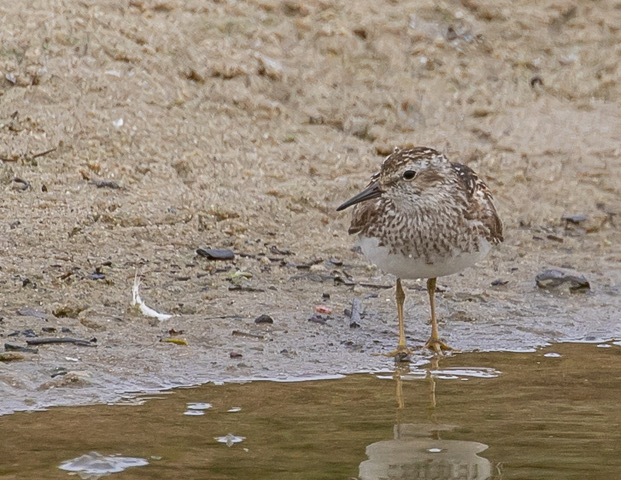
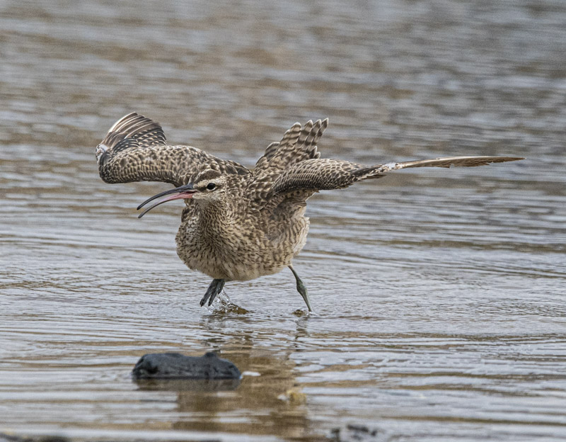
(Chris Tosdevin 7/26/26)
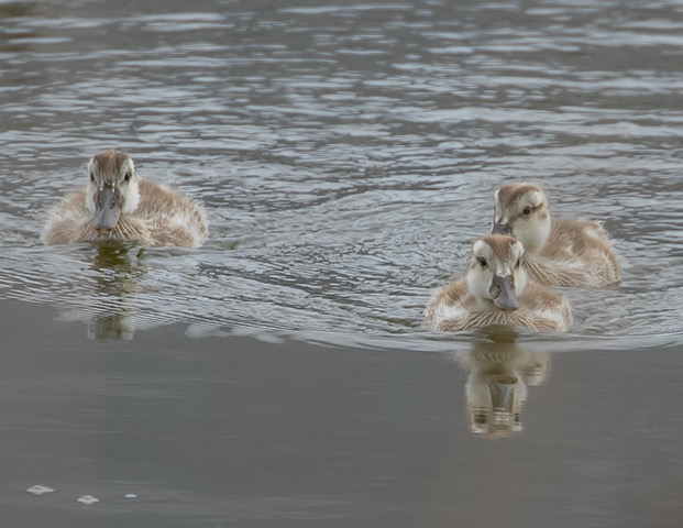
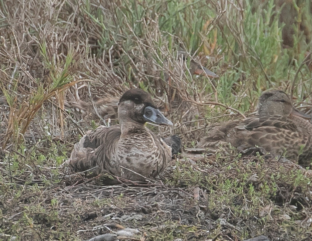
One question we get this time of year is how do we sort out the ducklings, as both Mallards and Gadwall breed at the lagoon. “Figure out who the mother is. She’s usually nearby.” Seriously. I can’t tell them apart until they start looking like adults. Google AI has offered me a lot of advice lately on getting my new computer working, so I inquired, and discovered these useful tips.
“In flight, the Gadwall’s neck is slightly thinner and the wings slightly more slender than a Mallard’s.
“The Mallard duckling has tiny webbed feet.”
Good to know.
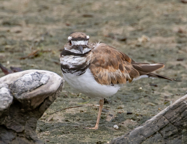
The Killdeer below is definitely molting, or perhaps beaten up. It may have been born a few months ago. When their breast rings first come in, they’re very messy.
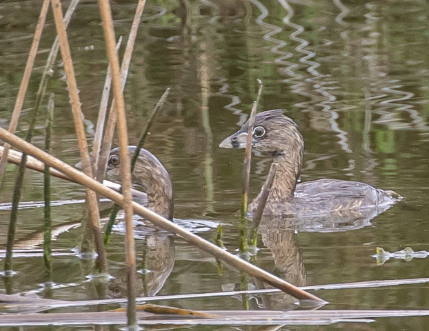
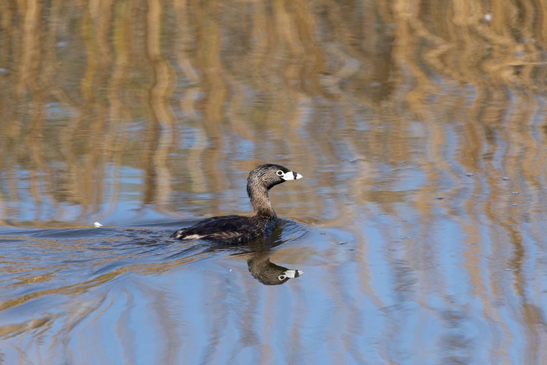
Pied-billed Grebes dive for their food. They are excellent swimmers and divers, partially because their legs are far back on their body. The downside of this structure is that they must avoid walking on land, which they do by nesting on the water among reeds from which they build their floating nests. A pair nested last year in the northern lagoon channel reed bed. If there was a pair there this year, their nest was very well hidden.
The Barn Swallows had a very good year, and the air was filled with them chasing flying insects. There’s a small dead tree near the PCH bridge upon which they love to rest. Easy on – easy off. There are at least eleven pictured below.

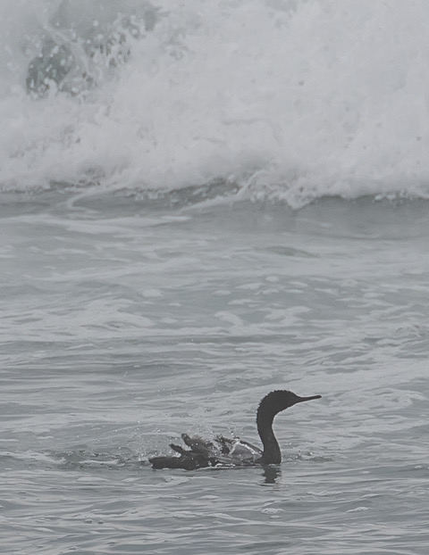
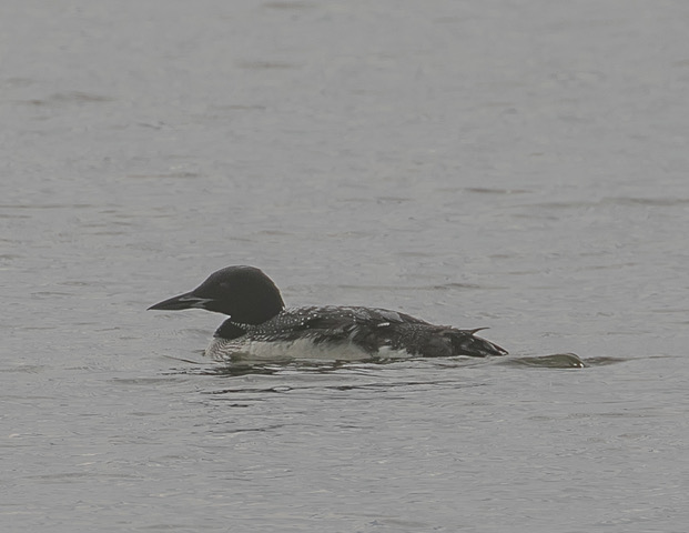
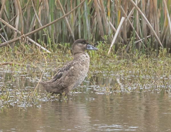
The most surprising bird of the trip was a Common Loon in breeding plumage, swimming in the lagoon and diving for fish. It then disappeared for a while, and those arriving late couldn’t find it. Like the grebes, loon’s legs are well back on their bodies and they cannot walk on land, so we figured it must have flown away.
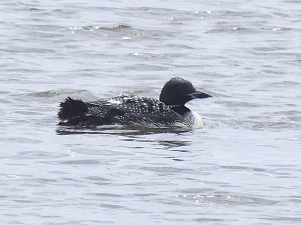
Later we relocated the loon on the eastern end of the southeast island in the channel. It was sitting on the ground. Whenever I see a grebe or loon on the ground I figure there’s a good chance that it’s sick or wounded, as they really don’t like being on land due to their inability to walk. But this loon had appeared active and healthy earlier. Another mystery.
Loons in general are rarely in breeding plumage in Southern California. In late spring, just as they’re leaving for their northern nesting waters, we may see a few that have already molted into their alternate (breeding) plumage. Malibu Lagoon is not a major stopover spot for them, but we can sometimes see skeins of them in the distance passing over the sea.
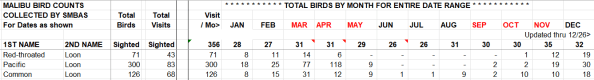
Below is a screen shot of loonish history at the lagoon. None of the three species are particularly common, and the Common Loon is not the most commonly seen. The Red-throated and Pacific Loons are not here at all in June – August. The Common Loon has previously appeared once in June, and this appearance was the first for July. We hold our trips at month’s end, and by the end of August, they’re a bit more common.
Another uncommon bird was the young Surf Scoter which was resting among a few dabbling ducks on the western island in the channels. Scoters are ocean birds and rarely come into the lagoon. Again, we wondered if it might be ill.
Later it stood up, walked around and showed us the pale belly of youth.
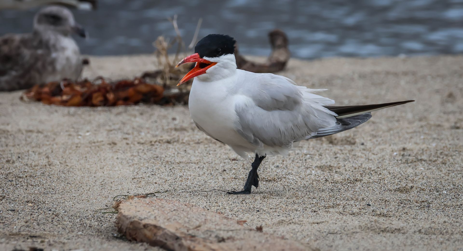
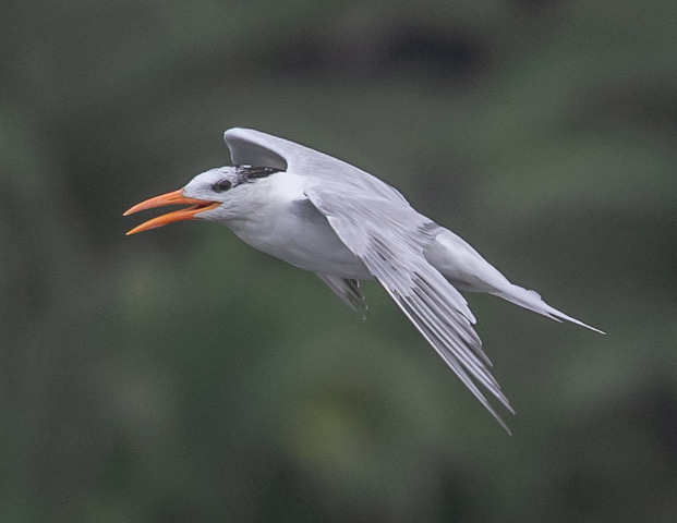
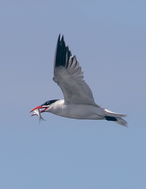
Caspian Terns, named for that well-known Sea, are usually the easiest tern to identify on our beach. They’re the largest, usually have the most black on their crowns, and their blood red bills usually have a dark tip.
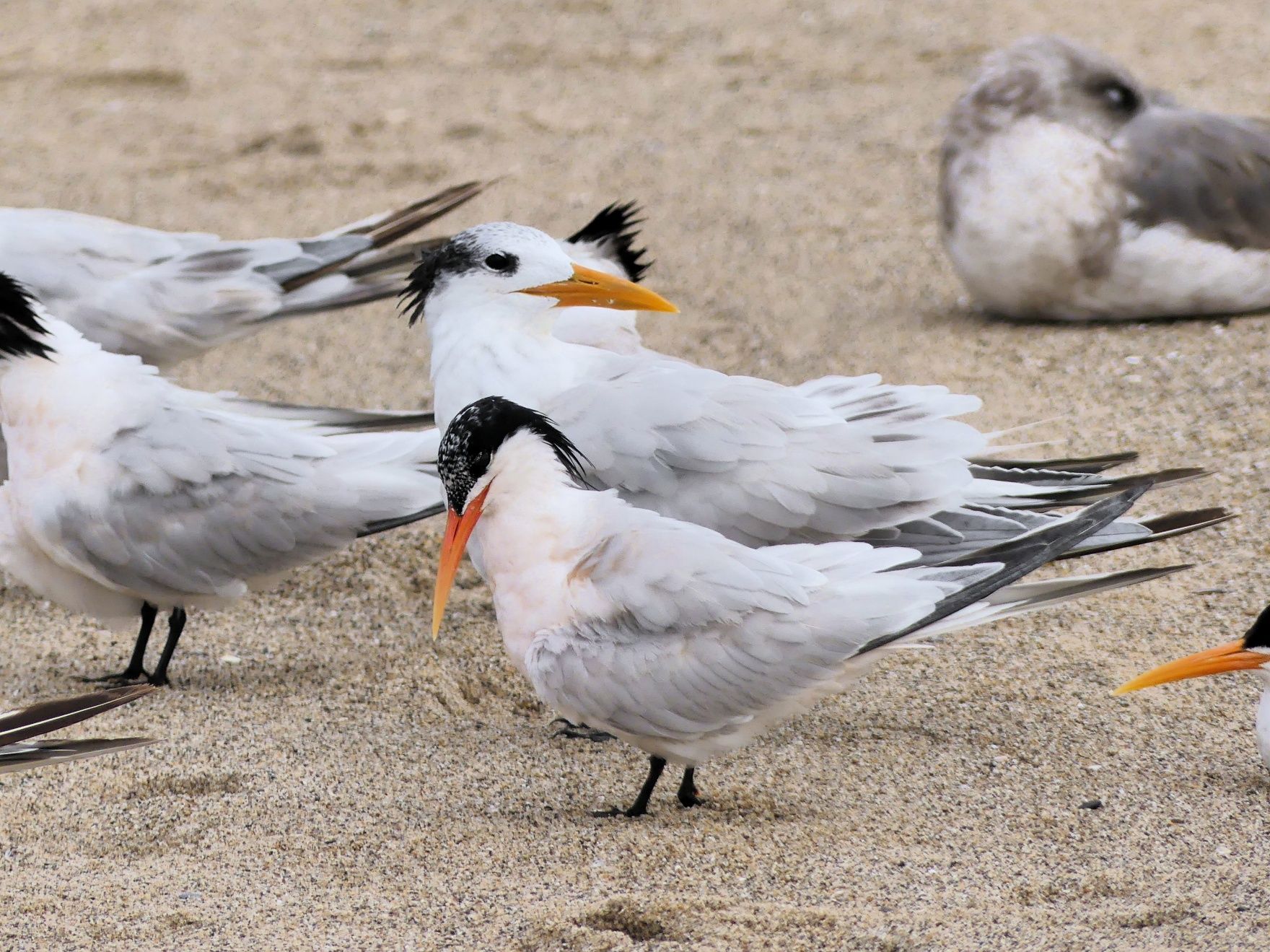
The slimmer bill of the Royal Terns ranges from dull yellow to bright orange, and their crowns don’t remain all-black for long. They tend to be slightly shorter than the Caspian and look a bit less bulky.
The Elegant Tern at 17″ is shorter and smaller than the 20-21″ Royal. Their caps remain darker than does the Royal’s, and the dark eye is nearly always “embedded” in the dark cap, whereas – when not in breeding plumage – the Royal’s eye is usually slightly separated from the cap. The bill color of both species range have the same range of dull yellow to bright orange, but the Royal’s bill is stouter and straighter than the Elegant’s bill. In breeding season the Elegant’s breast often has a slight rosy glow.
This Least Sandpiper seemed exceptionally stripe-breasted.
Egrets and herons have a variety of feeding and fish-luring maneuvers, such as this Great Egret’s water-wiggling. But I think the Black Heron (Egretta ardesiaca) of Southern Africa has them all beat. It pretends to be a short shady umbrella bush growing in the water, and the small fish in the overheated pond come to cool themselves around it’s shaded legs.

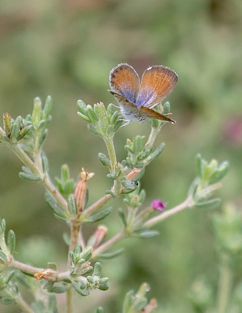
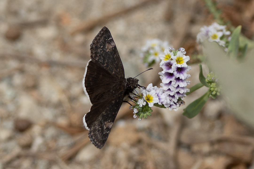
Chris Todevin is a whiz not only finding the smallest butterfly in the world (or at least North America), but then photographing it. Come to the lagoon and see if you can find them yourself. Tip: look for dust or leaf particles bouncing in the breeze; some of them are butterflies.
(Chris Tosdevin 7/26/26)
When it’s not breeding season, Heerman’s Gull is nearly always at the lagoon, giving proof that not all gulls are mostly white.

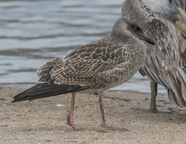
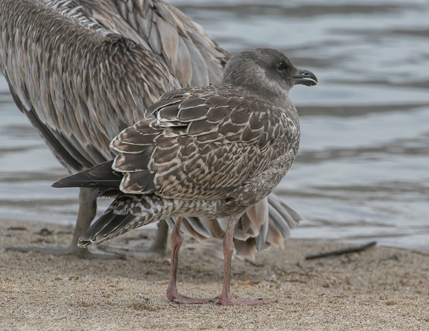
We were mystified for a while by this bird’s face with a dark “mask,” and ID’d it three ways. According to Chris Dean, gull maven at eBird, this mask effect is not uncommon among juvenile Western Gulls.
And finally, a brief story…

Overheard on Malibu Beach
Cormie: It was this big. I had it, I swear, but it got away!
Pete: Yeah, right. I wasn’t born yesterday!
Malibu Lagoon on eBird as of 7-28-26: 9538 lists, 3122 eBirders, 323 species
Most recent new species seen: Canyon Wren, 06/11/26 by Judith Olsen (no photo).
Birds new for the season: Black-chinned Hummingbird, Snowy Plover, Spotted Sandpiper, Ruddy Turnstone, Least Sandpiper, Common Loon, Western Bluebird, Lesser Goldfinch, Spotted Towhee. “New for the season” means it has been three or more months since last recorded on our trips.
Many, many thanks to photographers Femi Faminu, Ray Juncosa, Chris Tosdevin and Kathleen Waldron.
Upcoming SMBAS scheduled field trips; no reservations or Covid card necessary unless specifically mentioned:
- Malibu Lagoon, Sun. Aug 23, 8:30 am (adults) & 10 am (parents & kids)
- Malibu Lagoon, Sun. Sep 27, 8:30 am (adults) & 10 am (parents & kids)
- T.B.A., likely on Sat. Oct. 10, 8 or 8:30 am
- Malibu Lagoon, Sun. Oct 25, 8:30 am (adults) & 10 am (parents & kids)
- These and any other trips we announce for the foreseeable future will depend upon expected status of the Covid/flu/etc. pandemic, not to mention landslides, fires, local flooding and atmospheric rivers at trip time. Any trip announced may be canceled shortly before trip date if it seems necessary. By now any other comments should be superfluous.
- Link to Programs & Field Trip schedule.
The next SMBAS Zoom program: Tuesday, October 6, 7:30pm; TBA
The SMBAS 10 a.m. Parent’s & Kids Birdwalk has again resumed. Reservations not necessary for families, but for groups (scouts, etc.), please call Jean (213-522-0062).
Links: Unusual birds at Malibu Lagoon
9/23/02 Aerial photo of Malibu Lagoon
Aerial ‘film’ flying north over lagoon
More recent aerial photo
Prior checklists:
2025: Jan-June, July-Dec 2026: Jan-June
2023: Jan-June, July-Dec 2024: Jan-June, July-Dec
2021: Jan-July, July-Dec 2022: Jan-June, July-Dec
2020: Jan-July, July-Dec 2019: Jan-June, July-Dec
2018: Jan-June, July-Dec 2017: Jan-June, July-Dec
2016: Jan-June, July-Dec 2015: Jan-May, July-Dec
2014: Jan-July, July-Dec 2013: Jan-June, July-Dec
2012: Jan-June, July-Dec 2011: Jan-June, July-Dec
2010: Jan-June, July-Dec 2009: Jan-June, July-Dec
The 10-year comparison summaries created during the 2012-13 Lagoon Reconfiguration Project period, remain available—despite numerous complaints—on our Lagoon Project Bird Census Page. Very briefly summarized, the results unexpectedly indicate that avian species diversification and numbers improved slightly during the restoration period June’12-June’14. We also have a newly-refurbished slide show of the reconfiguration from just before it started until the recent 13-year celebration.
Many thanks to Marie Barnidge-McIntyre, Femi Faminu, Julie Rush, Chris Tosdevin and others for contributions made to this month’s census counts.
The species list below was re-sequenced as of 12/31/25 to agree with the eBird sequence. If part of the right side of the chart below is hidden, there’s a slider button inconveniently located at the bottom end of the list. The numbers 1-9 left of the species names are keyed to the nine categories of birds at the bottom. Updated lagoon bird check lists can be downloaded here.
[Chuck Almdale]
| Malibu Census 2026 | 2/22 | 3/22 | 4/26 | 5/24 | 6/28 | 7/26 | |
| Temperature | 49-63 | 65-76 | 55-64 | 60-63 | 61-66 | 72-76 | |
| Tide Lo/Hi Height | L+0.65 | L-0.31 | H+4.32 | L+0.42 | H+3.35 | H+3.49 | |
| Tide Time | 0655 | 0640 | 0624 | 1126 | 1034 | 0949 | |
| 1 | Brant (Black) | 1 | 1 | 1 | 2 | ||
| 1 | Cackling Goose | 1 | |||||
| 1 | Canada Goose | 4 | 5 | 4 | |||
| 1 | Cinnamon Teal | 2 | |||||
| 1 | Northern Shoveler | 2 | |||||
| 1 | Gadwall | 35 | 15 | 25 | 18 | 10 | 11 |
| 1 | American Wigeon | 4 | 6 | ||||
| 1 | Mallard | 7 | 14 | 8 | 12 | 15 | 35 |
| 1 | Northern Pintail | 1 | 1 | ||||
| 1 | Green-winged Teal | 8 | |||||
| 1 | Surf Scoter | 6 | 1 | 1 | |||
| 1 | Red-breasted Merganser | 7 | 4 | 3 | 1 | ||
| 2 | Feral Pigeon | 4 | 2 | 8 | 10 | 2 | |
| 2 | Mourning Dove | 3 | 1 | 3 | 2 | 3 | |
| 2 | Black-chinned Hummingbird | 1 | |||||
| 2 | Anna’s Hummingbird | 1 | 1 | 2 | 1 | 3 | |
| 2 | Allen’s Hummingbird | 3 | 5 | 2 | 6 | 3 | 6 |
| 3 | American Coot | 55 | 4 | 3 | 2 | ||
| 4 | Black-bellied Plover | 20 | 6 | 3 | 3 | 2 | 35 |
| 4 | Killdeer | 6 | 5 | 6 | 3 | 3 | 2 |
| 4 | Semipalmated Plover | 6 | |||||
| 4 | Snowy Plover | 4 | 1 | 17 | |||
| 4 | Hudsonian Whimbrel | 4 | 6 | 6 | 7 | 11 | |
| 4 | Long-billed Curlew | 1 | |||||
| 4 | Marbled Godwit | 4 | 1 | ||||
| 4 | Long-billed Dowitcher | 1 | |||||
| 4 | Spotted Sandpiper | 1 | |||||
| 4 | Willet | 3 | 4 | 9 | 1 | ||
| 4 | Ruddy Turnstone | 3 | 1 | ||||
| 4 | Sanderling | 10 | |||||
| 4 | Least Sandpiper | 20 | 8 | 3 | 2 | ||
| 4 | Western Sandpiper | 13 | 29 | ||||
| 5 | Bonaparte’s Gull | 3 | 1 | ||||
| 5 | Heermann’s Gull | 22 | 75 | 2 | 18 | 9 | |
| 5 | Ring-billed Gull | 4 | 3 | ||||
| 5 | Western Gull | 41 | 61 | 40 | 22 | 29 | 68 |
| 5 | American Herring Gull | 1 | 1 | 1 | |||
| 5 | California Gull | 140 | 95 | 110 | 6 | 1 | |
| 5 | Glaucous-winged Gull | 1 | |||||
| 5 | Caspian Tern | 3 | 11 | 3 | 5 | 1 | |
| 5 | Elegant Tern | 24 | 750 | 185 | 3 | 12 | |
| 5 | Royal Tern | 28 | 34 | 18 | 3 | 3 | 9 |
| 6 | Pied-billed Grebe | 2 | 3 | 1 | 6 | 3 | 4 |
| 6 | Western Grebe | 4 | 24 | 4 | 35 | 1 | |
| 6 | Clark’s Grebe | 2 | |||||
| 6 | Pacific Loon | 1 | 45 | 1 | |||
| 6 | Common Loon | 1 | |||||
| 6 | Brandt’s Cormorant | 5 | 3 | 4 | 2 | ||
| 6 | Pelagic Cormorant | 1 | 3 | 2 | 1 | 2 | 1 |
| 6 | Double-crested Cormorant | 15 | 18 | 26 | 25 | 10 | 30 |
| 6 | Black-crowned Night-Heron | 3 | |||||
| 6 | Snowy Egret | 3 | 1 | 2 | 3 | 2 | 8 |
| 6 | Green Heron | 2 | 1 | ||||
| 6 | Great Egret | 1 | 2 | 2 | 1 | 2 | |
| 6 | Great Blue Heron | 3 | 3 | 3 | 1 | 3 | 2 |
| 6 | Brown Pelican | 10 | 30 | 395 | 28 | 64 | 15 |
| 7 | Turkey Vulture | 2 | 3 | 4 | 10 | 2 | 2 |
| 7 | Osprey | 1 | |||||
| 7 | Sharp-shinned Hawk | 1 | |||||
| 7 | Red-shouldered Hawk | 2 | |||||
| 7 | Red-tailed Hawk | 2 | 1 | 1 | 1 | ||
| 8 | Belted Kingfisher | 1 | 1 | ||||
| 8 | Downy Woodpecker | 1 | |||||
| 8 | Nuttall’s Woodpecker | 1 | |||||
| 7 | Peregrine Falcon | 1 | 1 | ||||
| 9 | Western Flycatcher | 1 | |||||
| 9 | Black Phoebe | 3 | 2 | 2 | 4 | 2 | 1 |
| 9 | Say’s Phoebe | 1 | |||||
| 9 | Cassin’s Kingbird | 1 | 3 | 1 | |||
| 9 | Hutton’s Vireo | 1 | |||||
| 9 | California Scrub-Jay | 2 | 1 | 1 | |||
| 9 | American Crow | 10 | 6 | 2 | 8 | 8 | 4 |
| 9 | Common Raven | 1 | 2 | 1 | 1 | 1 | |
| 9 | Oak Titmouse | 1 | 1 | 1 | 3 | 2 | |
| 9 | Tree Swallow | 3 | |||||
| 9 | Violet-green Swallow | 2 | |||||
| 9 | No. Rough-winged Swallow | 25 | 5 | 3 | 2 | ||
| 9 | Barn Swallow | 8 | 12 | 15 | 35 | ||
| 9 | Cliff Swallow | 25 | 20 | 3 | 5 | ||
| 9 | Bushtit | 5 | 8 | 1 | 10 | 25 | 8 |
| 9 | Wrentit | 2 | 1 | 1 | 2 | 2 | |
| 9 | Swinhoe’s White-eye | 2 | 2 | ||||
| 9 | Ruby-crowned Kinglet | 1 | |||||
| 9 | Blue-gray Gnatcatcher | 1 | |||||
| 9 | Northern House Wren | 1 | 1 | ||||
| 9 | Bewick’s Wren | 1 | |||||
| 9 | European Starling | 10 | 13 | 2 | 6 | 5 | |
| 9 | Northern Mockingbird | 1 | |||||
| 9 | Western Bluebird | 3 | |||||
| 9 | American Robin | 1 | 1 | ||||
| 9 | House Finch | 10 | 12 | 10 | 9 | 7 | 22 |
| 9 | Lesser Goldfinch | 2 | 6 | 2 | |||
| 9 | Dark-eyed Junco | 1 | 2 | 1 | |||
| 9 | White-crowned Sparrow | 5 | 10 | ||||
| 9 | Song Sparrow | 7 | 6 | 6 | 4 | 4 | 3 |
| 9 | California Towhee | 2 | 3 | 1 | 2 | 2 | 1 |
| 9 | Spotted Towhee | 1 | |||||
| 9 | Hooded Oriole | 2 | 4 | 1 | |||
| 9 | Red-winged Blackbird | 2 | 5 | ||||
| 9 | Great-tailed Grackle | 3 | 5 | 4 | 8 | ||
| 9 | Orange-crowned Warbler | 1 | 1 | 1 | 1 | 1 | |
| 9 | Common Yellowthroat | 2 | 1 | ||||
| 9 | Yellow-rumped Warbler | 6 | 4 | ||||
| 9 | Black-headed Grosbeak | 1 | |||||
| Totals Birds by Type | Feb | Mar | Apr | May | Jun | Jul | |
| 1 | Waterfowl & Quail | 74 | 48 | 42 | 35 | 25 | 47 |
| 2 | Doves, Swifts & Hummers | 8 | 11 | 11 | 21 | 6 | 15 |
| 3 | Rails & Coots | 55 | 4 | 0 | 0 | 3 | 2 |
| 4 | Shorebirds | 74 | 44 | 54 | 6 | 22 | 70 |
| 5 | Gulls & Terns | 214 | 247 | 1005 | 221 | 60 | 99 |
| 6 | Grebe, Loon, Heron, Pelican | 47 | 134 | 435 | 105 | 91 | 63 |
| 7 | Hawks & Falcons | 7 | 4 | 6 | 11 | 3 | 3 |
| 8 | Kingfish, Peckers & Parrots | 2 | 0 | 2 | 0 | 0 | 0 |
| 9 | Passerines | 77 | 116 | 70 | 92 | 96 | 100 |
| Totals Birds | 558 | 608 | 1625 | 491 | 306 | 399 | |
| Total Species by Group | Feb | Mar | Apr | May | Jun | Jul | |
| 1 | Waterfowl & Quail | 9 | 8 | 6 | 6 | 2 | 3 |
| 2 | Doves, Swifts & Hummers | 3 | 4 | 3 | 4 | 3 | 5 |
| 3 | Rails & Coots | 1 | 1 | 0 | 0 | 1 | 1 |
| 4 | Shorebirds | 9 | 8 | 7 | 2 | 5 | 8 |
| 5 | Gulls & Terns | 5 | 10 | 7 | 6 | 7 | 5 |
| 6 | Grebe, Loon, Heron, Pelican | 11 | 11 | 8 | 10 | 10 | 8 |
| 7 | Hawks & Falcons | 4 | 2 | 3 | 2 | 2 | 2 |
| 8 | Kingfish, Peckers & Parrots | 2 | 0 | 2 | 0 | 0 | 0 |
| 9 | Passerines | 22 | 23 | 16 | 21 | 19 | 17 |
| Totals Species | 66 | 67 | 52 | 51 | 49 | 49 |
Is landfill junk food bad for storks? | The Guardian
Health risk fears for storks in Europe over ‘junk food’ from landfill
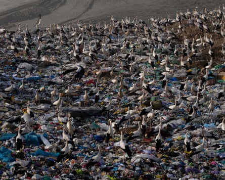
By Vandy Widyalankara, 8 July 2026
From the article:
Prof Aldina Franco, an ecologist at the University of East Anglia (UEA), who was not involved in the research, said the study broke new ground by looking at the effect of contaminants on the storks.
Food found in landfill is like “junk food” for birds, she said. “It’s food that is rotting and it’s poor quality, and probably highly energetic. So, they can get leftover steaks or leftover fish, everything we throw away to landfill sites.”
Franco added that the picture is nuanced: “It is true that it can be damaging for individual storks to eat these types of food that can have contaminants and diseases. But from a population perspective, if you’d have 500 storks going to a landfill site, maybe a few will die from eating these contaminated items, but the majority will actually benefit from having extra food.”
[posted by Emily Roth]
Bird Song & Acoustic Motifs | NPR & NAS
[Posted by Chuck Almdale, suggested by Lillian Johnson]
A recent study has found that birds world wide have only eight basic patterns of song, called “acoustic motifs.” Each of the more than 11,000 species of birds have their own special songs, croaks, burps, gurgles, wing-beating, foot-stomping or feather-whistling, but among the songsters in the passerine order, it’s only eight basic types. The NPR show Short Wave has a brief discussion of this study beginning at 7:50 on the recording below (preceded by an interesting discussion of avocado genetics). They play several sample bird songs and there’s a transcript available.
There is a longer article from the National Audubon Society, which also includes song snippets so you can hear the various motifs.
The team analyzed more than 116,000 songs from 3,160 passerine species, the diverse group that includes all songbirds and more than 60 percent of all birdlife. Their analysis revealed the eight “building blocks” that all these birds draw from when they sing: slow, fast, and ultrafast trills; flat, slow-modulated, and fast-modulated whistles; harmonic stacks; and chaotic notes. The Eastern Wood-Pewee’s “pee-ah-wee,” for example, illustrates the slow-modulated whistle, which sounds like a smooth, plaintive curve of sound, with just a gradual pitch change. The Bohemian Waxwing, meanwhile, offers a great case of the ultrafast trill: high-pitched, rapid-fire pulses that blur together.
Many years ago, there were Birding By Ear audio tapes available to help in learning bird songs, Eastern and Western versions. One point that stuck in my mind and remains useful is that both American Robin and Black-headed Grosbeak had slow rolling musical songs of similar pitch, but the robin’s was slightly faster.
Read and listen. I guarantee you’ll never hear birds the same way again.
The original paper is The global biogeography of passerine songs by Quentin Bacquelé, Jean-Yves Barnagaud, Cyrille Violle, Frédéric Theunissen and Nicolas Mathevon, published by Science, 23 Jul 2026, Vol 393, Issue 68. It’s behind the usual paywall, but if you have access, here it is.
Editor’s summary
Birds sing to attract mates and ward off rivals. The form of these songs can vary from single, repeated notes to complex melodies. Bacquelé et al. explored the relationships among song, environment, and latitude from birds across the world (see the Perspective by Briefer). They found that in regions where forests are thick, and thus sound transmission is slower, bird songs are simpler and more effective for transmission across vegetation-impeded landscapes. By contrast, in temperate regions, where sound is less impeded and sexual selection is especially strong due to seasonal limitations, birdsong is much more complex, likely being a better indicator of singer condition. —Sacha Vignieri
Abstract
Although bird songs are classic models for understanding the evolution of vocal communication, their global diversity has long made the development of a unifying framework challenging. By analyzing the acoustic architecture of songs from more than 3000 passerine species worldwide, we show that this acoustic space can be structured around eight elemental motifs. The differential use of these motifs is driven by a combination of species’ biological traits (social organization, morphology, and mating system) and the physics of sound propagation. In tropical rainforests, environmental filtering for transmission efficiency favors structurally simple motifs, such as flat whistles. Conversely, in temperate regions, where high population densities facilitate close-range communication and short breeding seasons intensify sexual selection, the balance shifts toward complex, information-rich motifs, such as ultrafast trills, despite their susceptibility to acoustic degradation. Ultimately, the global geography of birdsong reflects a spatially varying equilibrium between physical environmental constraints and the biological drive for complex communication.
Getting a different perspective on things?
Always the 4th (not last) Sunday of the month, 8:30am & 10 am
Pacific Coast Highway: There are still reportedly lane closures as fire recovery work continues.
- 25 MPH between Temescal Canyon Rd. & Sunset Blvd.
- 35 MPH between Sunset Blvd & Carbon Beach Terrace
- Watch for workers & vehicles. (Active work on Sunday morning at 8am? Take a picture.)
Special Attractions: Like dinosaurs? Want to see a dinosaur? Our feathered dinosaurs have no teeth and won’t bother you, although if you happen to have a small snail or fly in your pocket, they might be interested.
Some of the great birds we’ve had in July are:
Gadwall, Pied-billed and Eared Grebe, Anna’s & Allen’s Hummingbirds, Snowy Plover, Whimbrel, Wilson’s Phalarope, Spotted Sandpiper, Wandering Tattler, Willet, Ruddy & Black Turnstones, Red Knot, Surfbird, Western Sandpiper, Heermann’s & Western Gulls, Black Skimmer, Least, Caspian, Royal & Elegant Terns, Reddish Egret, Great Blue Heron, Brown Pelican, Red-shouldered Hawk, Belted Kingfisher, Oak Titmouse, Rough-winged, Barn and Cliff Swallows, Wrentit, Northern Mockingbird, American Robin, House Finch, American Goldfinch, Savannah & Song Sparrow, California Towhee, Hooded Oriole, Red-winged Blackbird, Common Yellowthroat.
(Marie Barnidge-McIntyre 7/28/24)
Weather prediction as of 22 July
Temp: 71-74°F; Wind 2-7 mph from SE; Sky Cover: 28%
Tide: medium, little change: Low: -0.2 ft. @ 3:09am High: +3.49 ft. @ 9:49am
June 28 trip report link
Adult Walk 8:30 a.m., 4th Sunday of every month. Adults, teens and children you deem mature enough to be with adults. Beginners and experienced, 2-3 hours, meeting at the metal-shaded viewing area between parking lot and channel. Species range from 35 in June to 60-75 during migrations and winter. We move slowly and check everything as we move along. When lagoon outlet is closed we may continue east around the lagoon to Adamson House. We put out special effort to make our monthly Malibu Lagoon walks attractive to first-time and beginning birdwatchers. So please, if you are at all worried about coming on a trip and embarrassing yourself because of all the experts, we remember our first trips too. Someone showed us the birds; now it’s our turn. Bring your birding questions.
Children and Parents Walk, 10:00 a.m., 4th Sunday of every month: One hour session, meeting at the metal-shaded viewing area between parking lot and channel. We start at 10:00 for a shorter walk and to allow time for families to get it together on a sleepy Sunday morning. Our leaders are experienced with kids so please bring them to the beach! We have an ample supply of binoculars that children can use without striking terror into their parents. We want to see families enjoying nature. (If you have a Scout Troop or other group of more than seven people, you must call Jean (213-522-0062) to make sure we have enough binoculars, docents and sand.) It’s a good idea to call Jean anyway so she knows to expect you. If you’re late, they’re probably heading towards the beach.
Directions: Malibu Lagoon – street address is 3999 Cross Creek Rd. – is at the stoplighted intersection of Pacific Coast Highway (PCH) and Cross Creek Road, just west of Malibu Pier and the bridge, 15 miles west of Santa Monica via PCH. Turn towards the ocean at the stoplight, opposite the Shell station. We gather in the metal-shaded pavilion area near the parking lot. Look around for people wearing binoculars and hats. Do NOT go to 23200 PCH, the address for Adamson House, east of Malibu Creek bridge, and a 5-10 minute walk away, plus 20-40 minutes to get into their surfer-packed parking lot.
Parking: Parking machine in the lagoon lot near our meeting area: 1 hr $3; 2 hrs $6; 3 hrs $9, all day $12 ($11 seniors); credit cards accepted. Annual passes accepted. You may also park (read the signs carefully) either along PCH west of Cross Creek Road, on Cross Creek Road, or on Civic Center Way north (inland) of the shopping center. Lagoon parking in shopping center lots is not permitted.
(Ray Juncosa 7-27-25)
[Written & posted by Chuck Almdale]
June is for Jumpers: Malibu Lagoon: 28 June 2026
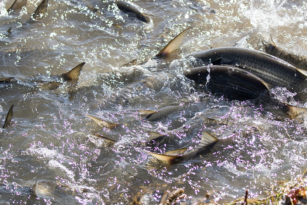
(Chris Tosdevin 6-28-26)
[By Chuck Almdale; photos by Ray Juncosa, Armando Martinez & Chris Tosdevin]
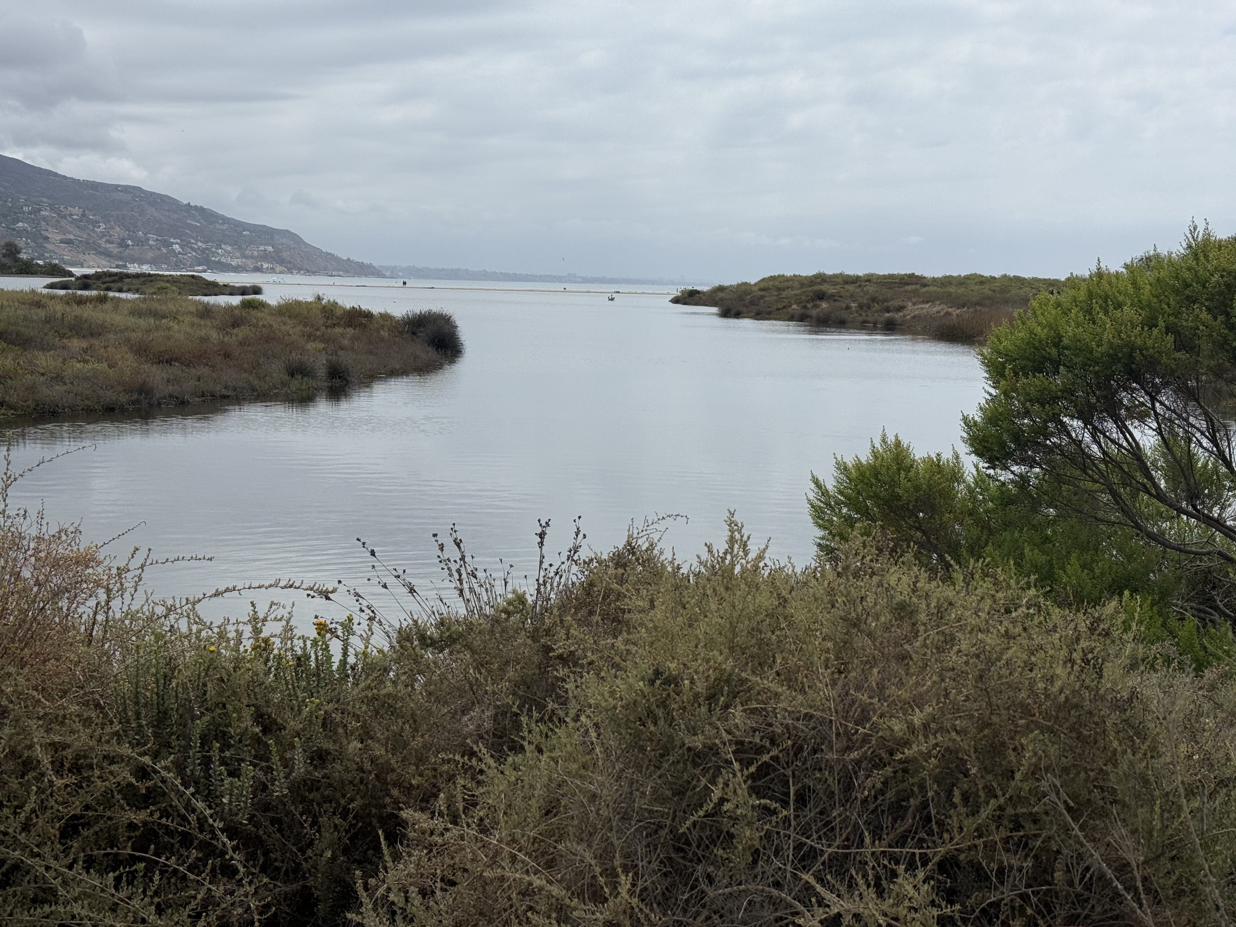
This is what June Gloom looks like. Some people complain about it (“It’s summer! It’s supposed to be sunny here!”) but it keeps the temperatures down, and if any Night Herons are around, you can see them out and about instead of hiding in thick tree foliage to protect their eyesight. Surfrider’s Beach, the southern border of Malibu Lagoon, looks extremely thin in this photo below. In reality it’s several hundred feet from lagoon to ocean.
The world’s ten species of night heron are misleadingly named. They have large eyes (for a heron), but they don’t seek the darkness of night; they like crepuscular light, the twilight of dawn and dusk. A Gloomy June day will also do.
Their eyes evolved to see best in dim light, but a gloomy day also works well for a hungry bird. They do like to hide and hunt for small fish and invertebrates in reed beds, but you can also see them on the shorelines when it’s sufficiently gloomy.

But our featured fauna this month is not a bird, but a fish. It’s a Mullet, Mugil cephalus to be specific. I prefer the name Jumping Mullet because…well look below. But they have many names, as often happens with common fish. In English alone there are at least 28 names for this Mullet: Black, Black True, Bright, Bully, Callifaver, Common Gray, Common, Flat-head Gray, Flathead Gray, Flathead Gray-, Flathead, Gray, Haarder, Hardgut, Hardgut River, Jumping, Longaram, Mangrove, Poddies, Poddy, River, Sand, Sea, Springer, Striped, Stripped, Yellow-tailed, and just plain Mullet. The most widespread and “official” English name is Striped Mullet. In all languages there are over 500 different names. It’s a common, widespread fish along coasts around the world.
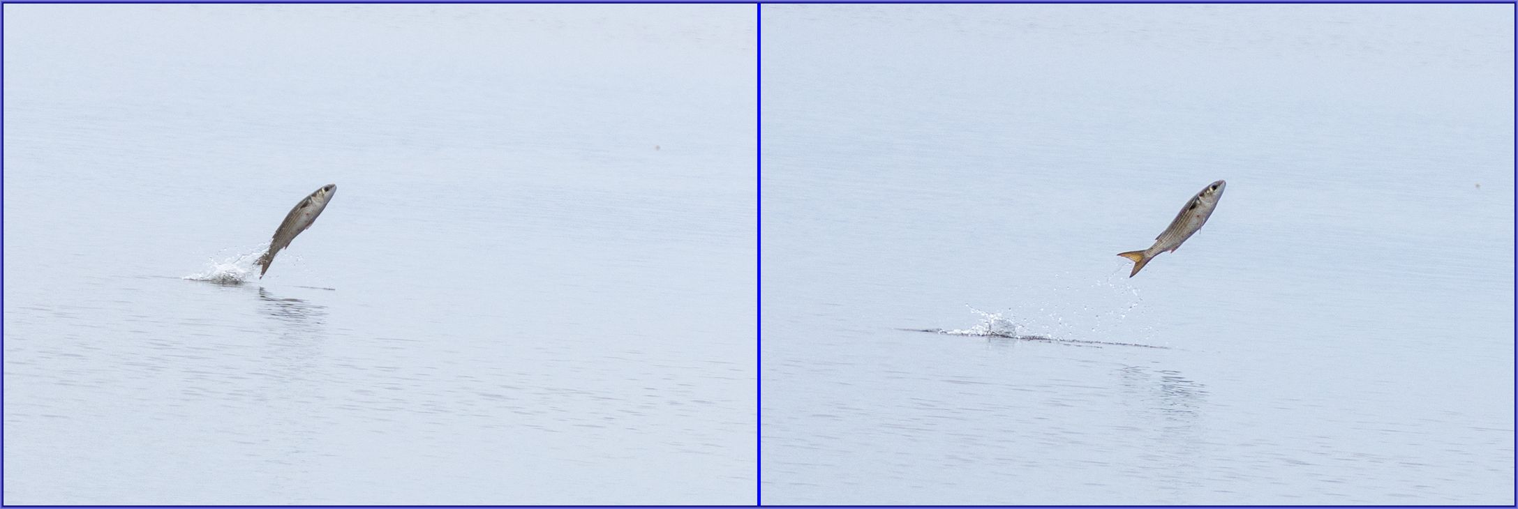
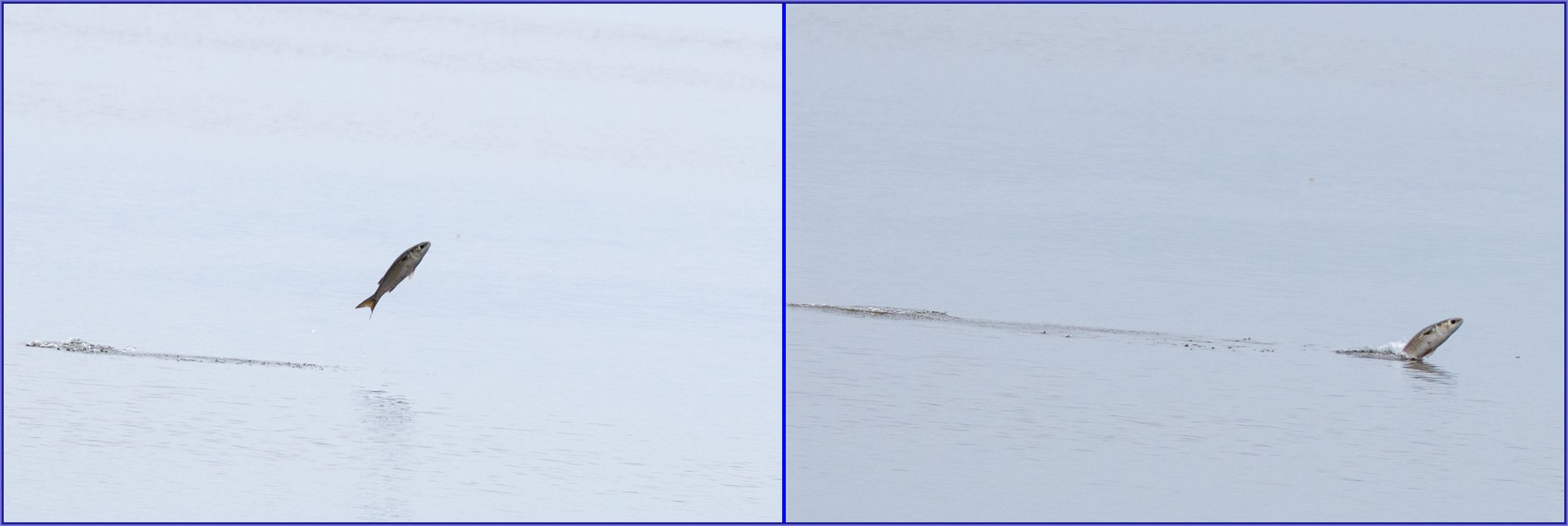
I’ve never seen so many jumping Jumping Mullet in the lagoon. I started counting their jumps and within 45 minutes I’d gone over 100 and decided to quit keeping track, but within a few seconds it was 110. The most simultaneous jumps were three, and the fastest “run” was 7 jumps in 10 seconds.

There was an enormous mullet die-off in Malibu Lagoon back in August 2018. High ocean temperatures, high lagoon water temperatures, and just plain high temperatures lowered the oxygen level in the lagoon to a lethal level, and withing a week perhaps 3000-5000 dead mullet were floating on the surface. No one (to my knowledge) knew that there were that many in the lagoon.
Some interesting Mullet factoids:
- Their common size is 10-20″ and 1-3 lbs., but can grow as large as 47″ and 18 lbs.
- Mugil cephalus translates to “suck head.”
- They have a segments in their stomach that function like a bird’s gizzard. They feed by slurping up sediment, detritus and algae, and the sand and mud help grind up the plant material.
- They are notorious for jumping out of the water; theories abound as to why (see below).
- They are euryhaline, able to easily tolerate very different levels of salinity, from hypersaline coastal lagoons to ordinary sea water to brackish water and to freshwater rivers.
- The adults migrate offshore in late fall and early winter to spawn in massive schools. The hatched juveniles later migrate back to shore and into food-rich, low-salinity estuaries like Malibu Lagoon to grow.
- In the coastal waters of SoCal and Baja California the large schools of mullet can attract large “sportfish” to feed on them, themselves attracting boats filled with sportfishermen.

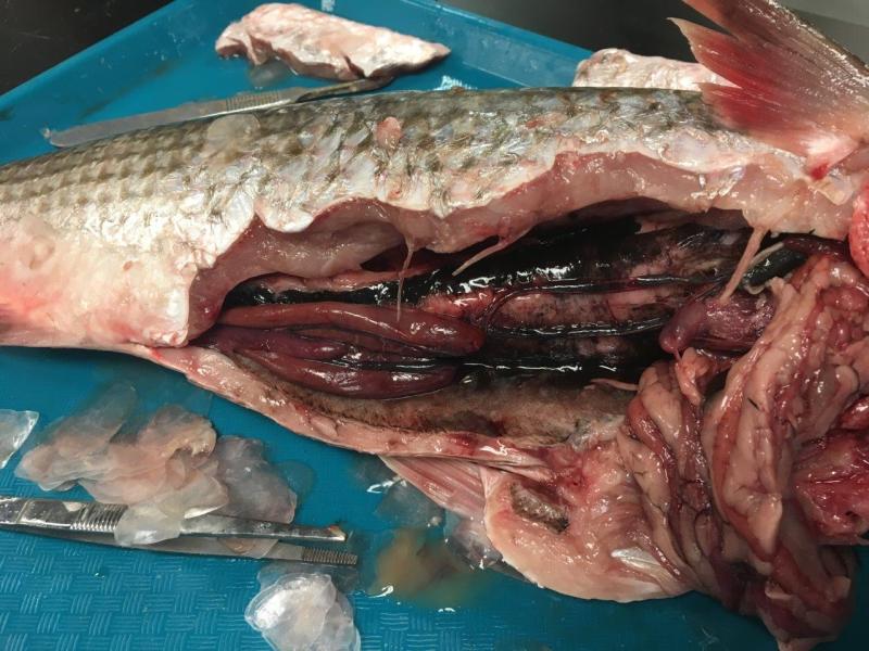
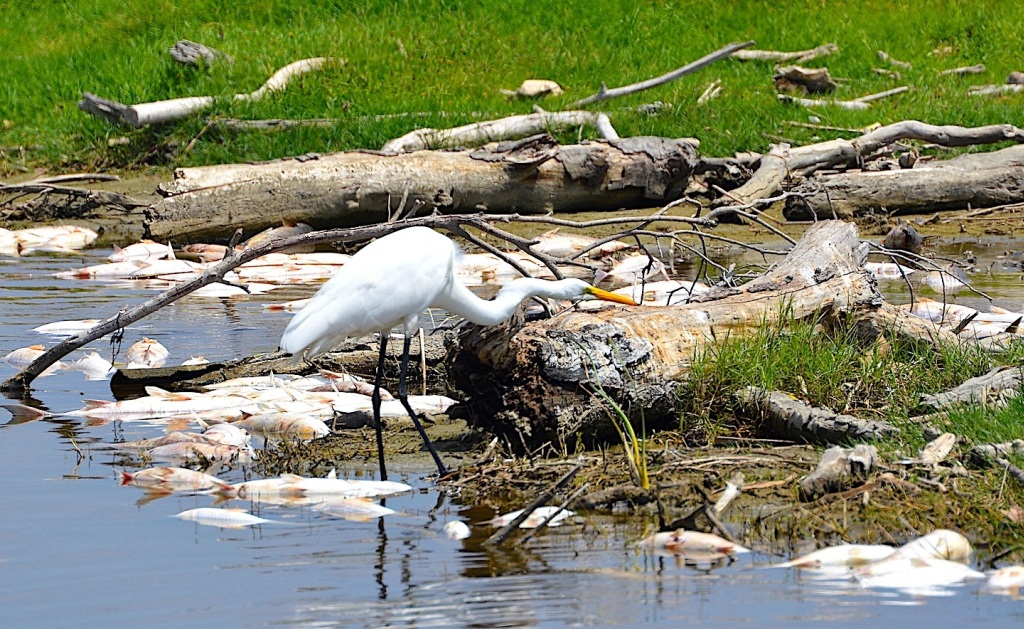
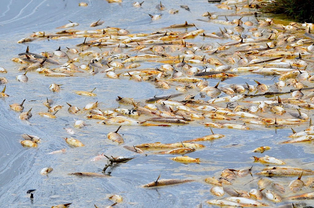
Above, clockwise from upper left: Mullets at lagoon’s edge (Jim Kenney 9/28/15), Jumping Mullet (Randy Ehler 9/27/15), Necropsy of lagoon Mullet, nothing negative discovered (Karina Johnston, Bay Foundation 8/24/18), Over 200 dead Mullet (Larry Loeher 8/26/18, Great Egret & dead mullet (Grace Murayama 8/24/18)
These are some of the theories why they jump. I suspect there’s a Ph.D. waiting for anyone who solves this question.
- Display to attract a mate
- Escape a larger predator
- Gulp some oxygen
- Catch an insect it sees in the air
- Shake off loose parasites or growths on its skin
- Catch an invertebrate it sees at the water’s surface and momentum carries them into the air
- Communicate location to other fish or other schools
- Show off to the other fish what a great jumper they are
- It’s fun and feels great slapping back down (my favorite explanation)
It’s probably all of the above, depending on the situation. Fish can be versatile.
Back to the birds.
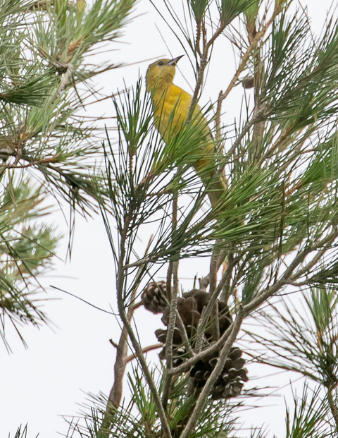
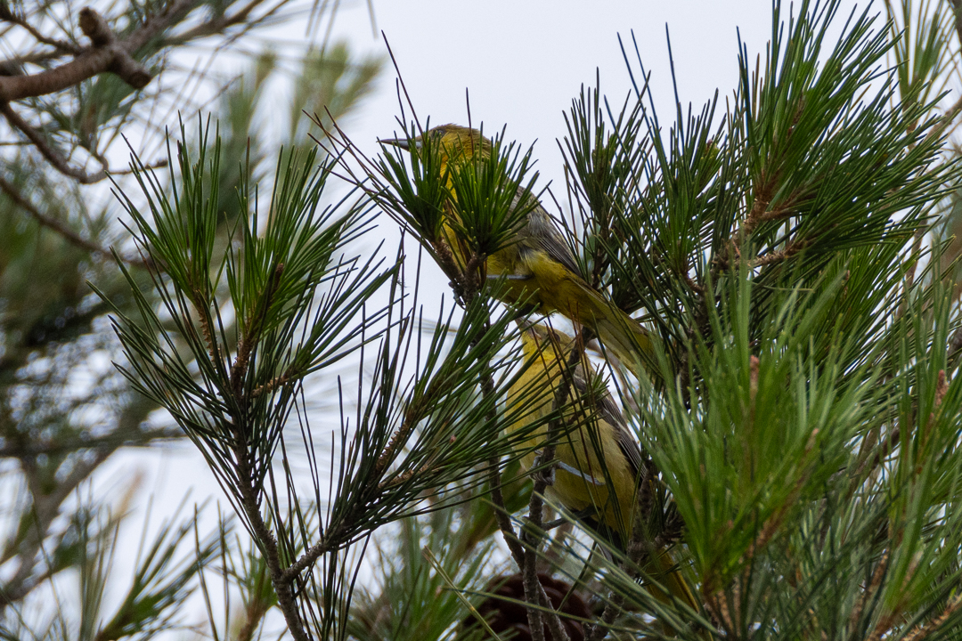
The Hooded Orioles seem to nest at the lagoon every year now, although we often don’t see them and we rarely find their nests. They prefer to suspend their woven nests from the underside of the central shaft of a palm frond. You’d think they’d be easy to find, but they aren’t. I’ve seen only two, maybe three such nests at the lagoon. Today we were lucky and manage to find four orioles, probably the entire family, in the trees at the back of the Malibu Colony. Here, and in the trees around the parking lot, are their usual locations.

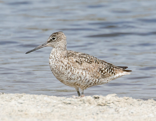
Willets, when they fly, can look quite spectacular.
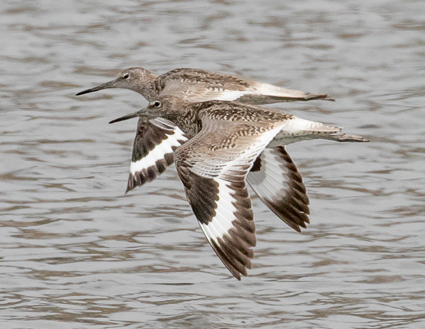
When then settle down, the stripes disappear. But this time of year, still in some of their breeding plumage, they are attractively spotted. In the winter, all that disappears and they are plain, plain gray.
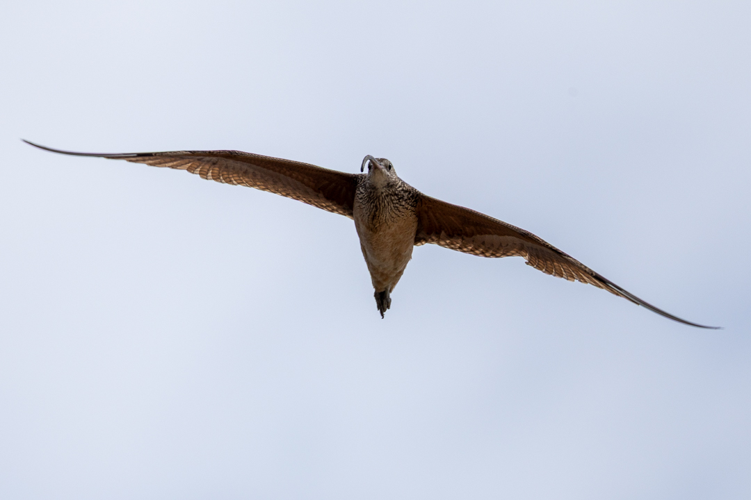
Was this Whimbrel startled? Chasing something? Being chased? We don’t know.
…and study this bird for a while before reading the caption. Do you know what it is?
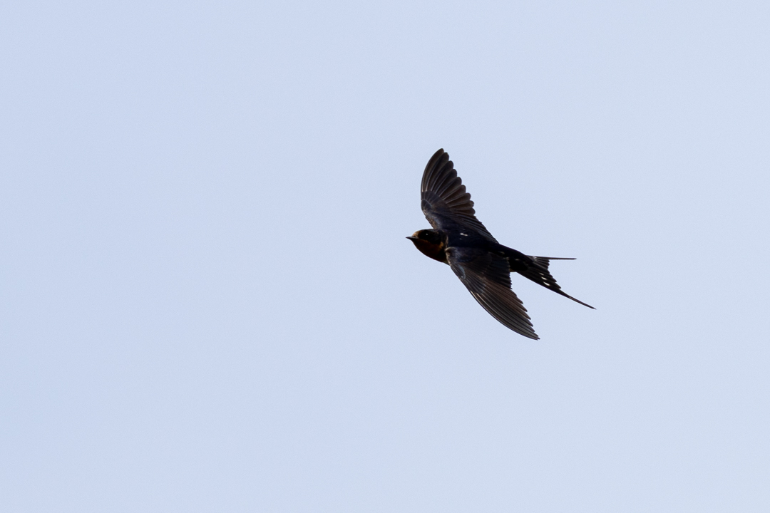
We have more swallow species than just “the Swallow.” This is not the one that mythically returns to San Juan Capistrano on March 19, St. Joseph’s Day. That’s the Cliff Swallow and they frequently begin reappearing in SoCal in February, back from their sojourn in sunny Argentina.
The Heermann’s Gulls are definitely back from breeding on Isla Rasa in the Sea of Cortez.
Most of the Glaucous-winged Gulls we get at the lagoon are first-year birds. This one looks like a two-year old, with the two-tone bill and the pale gray back. It’s a bit early for it to be back from the arctic, so it probably never bothered to fly north this year.
We didn’t get a picture of it, but one of the passerines that rarely show up at the lagoon made an appearance. It likely was a young bird and didn’t know any better. This Black-headed Grosbeak was only the fourth one we’ve seen at the lagoon in 348 visits. They prefer brushy hillsides and leafy trees to sparse brush, thus their relative rarity at the lagoon.
And for you butterfly mavens, what is this? Tell us what and why, and we’ll correct this posting with your name credited. Fame and fortune will no doubt rapidly ensue, and you will be able to retire to a lifetime of butterfly-watching.
Malibu Lagoon on eBird as of 7-01-26: 9494 lists, 3107 eBirders, 323 species
Most recent new species seen: Canyon Wren, 06/11/26 by Judith Olsen (no photo).
Birds new for the season: American Coot, Long-billed Curlew, Willet, Glaucous-winged Gull, Black-crowned Night Heron, Green Heron, Red-tailed Hawk, American Robin, Black-headed Grosbeak. “New for the season” means it has been three or more months since last recorded on our trips.
Many, many thanks to photographers Ray Juncosa, Armando Martinez and Chris Tosdevin.
Upcoming SMBAS scheduled field trips; no reservations or Covid card necessary unless specifically mentioned:
- Malibu Lagoon, Sun. July 26, 8:30 am (adults) & 10 am (parents & kids)
- Malibu Lagoon, Sun. Aug 23, 8:30 am (adults) & 10 am (parents & kids)
- Malibu Lagoon, Sun. Sep 27, 8:30 am (adults) & 10 am (parents & kids)
- These and any other trips we announce for the foreseeable future will depend upon expected status of the Covid/flu/etc. pandemic, not to mention landslides, fires, local flooding and atmospheric rivers at trip time. Any trip announced may be canceled shortly before trip date if it seems necessary. By now any other comments should be superfluous.
- Link to Programs & Field Trip schedule.
The next SMBAS Zoom program: Tuesday, October 6, 7:30pm; TBA
The SMBAS 10 a.m. Parent’s & Kids Birdwalk has again resumed. Reservations not necessary for families, but for groups (scouts, etc.), please call Jean (213-522-0062).
Links: Unusual birds at Malibu Lagoon
9/23/02 Aerial photo of Malibu Lagoon
Aerial ‘film’ flying north over lagoon
More recent aerial photo
Prior checklists:
2025: Jan-June, July-Dec
2023: Jan-June, July-Dec 2024: Jan-June, July-Dec
2021: Jan-July, July-Dec 2022: Jan-June, July-Dec
2020: Jan-July, July-Dec 2019: Jan-June, July-Dec
2018: Jan-June, July-Dec 2017: Jan-June, July-Dec
2016: Jan-June, July-Dec 2015: Jan-May, July-Dec
2014: Jan-July, July-Dec 2013: Jan-June, July-Dec
2012: Jan-June, July-Dec 2011: Jan-June, July-Dec
2010: Jan-June, July-Dec 2009: Jan-June, July-Dec
The 10-year comparison summaries created during the 2012-13 Lagoon Reconfiguration Project period, remain available—despite numerous complaints—on our Lagoon Project Bird Census Page. Very briefly summarized, the results unexpectedly indicate that avian species diversification and numbers improved slightly during the restoration period June’12-June’14. We also have a newly-refurbished slide show of the reconfiguration from just before it started until the recent 13-year celebration.
Many thanks to Marie Barnidge-McIntyre, Armando Martinez (our new chapter president), Chris Tosdevin and others for contributions made to this month’s census counts. June is typically the month with the fewest birds and lowest diversity.
The species list below was re-sequenced as of 12/31/25 to agree with the eBird sequence. If part of the right side of the chart below is hidden, there’s a slider button inconveniently located at the bottom end of the list. The numbers 1-9 left of the species names are keyed to the nine categories of birds at the bottom. Updated lagoon bird check lists can be downloaded here.
[Chuck Almdale]
| Malibu Census 2026 | 1/25 | 2/22 | 3/22 | 4/26 | 5/24 | 6/28 | |
| Temperature | 47-55 | 49-63 | 65-76 | 55-64 | 60-63 | 61-66 | |
| Tide Lo/Hi Height | L+1.31 | L+0.65 | L-0.31 | H+4.32 | L+0.42 | H+3.35 | |
| Tide Time | 0846 | 0655 | 0640 | 0624 | 1126 | 1034 | |
| 1 | Brant (Black) | 1 | 1 | 1 | 1 | 2 | |
| 1 | Cackling Goose | 1 | |||||
| 1 | Canada Goose | 3 | 4 | 5 | 4 | ||
| 1 | Cinnamon Teal | 2 | |||||
| 1 | Northern Shoveler | 2 | |||||
| 1 | Gadwall | 34 | 35 | 15 | 25 | 18 | 10 |
| 1 | American Wigeon | 4 | 4 | 6 | |||
| 1 | Mallard | 5 | 7 | 14 | 8 | 12 | 15 |
| 1 | Northern Pintail | 1 | 1 | ||||
| 1 | Green-winged Teal | 11 | 8 | ||||
| 1 | Surf Scoter | 3 | 6 | 1 | |||
| 1 | Red-breasted Merganser | 6 | 7 | 4 | 3 | 1 | |
| 2 | Feral Pigeon | 4 | 2 | 8 | 10 | ||
| 2 | Mourning Dove | 3 | 1 | 3 | 2 | ||
| 2 | Anna’s Hummingbird | 1 | 1 | 2 | 1 | ||
| 2 | Allen’s Hummingbird | 3 | 3 | 5 | 2 | 6 | 3 |
| 3 | American Coot | 50 | 55 | 4 | 3 | ||
| 4 | Black Oystercatcher | 3 | |||||
| 4 | Black-bellied Plover | 34 | 20 | 6 | 3 | 3 | 2 |
| 4 | Killdeer | 4 | 6 | 5 | 6 | 3 | 3 |
| 4 | Semipalmated Plover | 6 | |||||
| 4 | Snowy Plover | 17 | 4 | 1 | |||
| 4 | Hudsonian Whimbrel | 3 | 4 | 6 | 6 | 7 | |
| 4 | Long-billed Curlew | 1 | |||||
| 4 | Marbled Godwit | 3 | 4 | 1 | |||
| 4 | Long-billed Dowitcher | 1 | |||||
| 4 | Willet | 7 | 3 | 4 | 9 | ||
| 4 | Ruddy Turnstone | 2 | 3 | ||||
| 4 | Sanderling | 35 | 10 | ||||
| 4 | Least Sandpiper | 20 | 20 | 8 | 3 | ||
| 4 | Western Sandpiper | 13 | 29 | ||||
| 5 | Bonaparte’s Gull | 3 | 1 | ||||
| 5 | Heermann’s Gull | 22 | 75 | 2 | 18 | ||
| 5 | Ring-billed Gull | 17 | 4 | 3 | |||
| 5 | Western Gull | 45 | 41 | 61 | 40 | 22 | 29 |
| 5 | American Herring Gull | 1 | 1 | ||||
| 5 | California Gull | 275 | 140 | 95 | 110 | 6 | 1 |
| 5 | Glaucous-winged Gull | 1 | 1 | ||||
| 5 | Caspian Tern | 3 | 11 | 3 | 5 | ||
| 5 | Elegant Tern | 24 | 750 | 185 | 3 | ||
| 5 | Royal Tern | 12 | 28 | 34 | 18 | 3 | 3 |
| 6 | Pied-billed Grebe | 2 | 2 | 3 | 1 | 6 | 3 |
| 6 | Western Grebe | 45 | 4 | 24 | 4 | 35 | 1 |
| 6 | Clark’s Grebe | 2 | |||||
| 6 | Red-throated Loon | 2 | |||||
| 6 | Pacific Loon | 1 | 45 | 1 | |||
| 6 | Brandt’s Cormorant | 35 | 5 | 3 | 4 | 2 | |
| 6 | Pelagic Cormorant | 1 | 3 | 2 | 1 | 2 | |
| 6 | Double-crested Cormorant | 28 | 15 | 18 | 26 | 25 | 10 |
| 6 | Black-crowned Night-Heron | 3 | |||||
| 6 | Snowy Egret | 3 | 3 | 1 | 2 | 3 | 2 |
| 6 | Green Heron | 2 | 1 | ||||
| 6 | Great Egret | 1 | 1 | 2 | 2 | 1 | |
| 6 | Great Blue Heron | 5 | 3 | 3 | 3 | 1 | 3 |
| 6 | Brown Pelican | 13 | 10 | 30 | 395 | 28 | 64 |
| 7 | Turkey Vulture | 2 | 2 | 3 | 4 | 10 | 2 |
| 7 | Osprey | 2 | 1 | ||||
| 7 | Sharp-shinned Hawk | 1 | |||||
| 7 | Red-shouldered Hawk | 2 | |||||
| 7 | Red-tailed Hawk | 1 | 2 | 1 | 1 | ||
| 8 | Belted Kingfisher | 1 | 1 | 1 | |||
| 8 | Downy Woodpecker | 1 | |||||
| 8 | Nuttall’s Woodpecker | 1 | |||||
| 7 | Peregrine Falcon | 1 | 1 | ||||
| 8 | Nanday Parakeet | 2 | |||||
| 9 | Western Flycatcher | 1 | |||||
| 9 | Black Phoebe | 3 | 3 | 2 | 2 | 4 | 2 |
| 9 | Say’s Phoebe | 1 | |||||
| 9 | Cassin’s Kingbird | 1 | 3 | 1 | |||
| 9 | Hutton’s Vireo | 1 | 1 | ||||
| 9 | California Scrub-Jay | 2 | 1 | ||||
| 9 | American Crow | 11 | 10 | 6 | 2 | 8 | 8 |
| 9 | Common Raven | 1 | 2 | 1 | 1 | 1 | |
| 9 | Oak Titmouse | 1 | 1 | 1 | 3 | ||
| 9 | Tree Swallow | 3 | |||||
| 9 | Violet-green Swallow | 2 | |||||
| 9 | No. Rough-winged Swallow | 25 | 5 | 3 | 2 | ||
| 9 | Barn Swallow | 8 | 12 | 15 | |||
| 9 | Cliff Swallow | 25 | 20 | 3 | |||
| 9 | Bushtit | 20 | 5 | 8 | 1 | 10 | 25 |
| 9 | Wrentit | 2 | 2 | 1 | 1 | 2 | 2 |
| 9 | Swinhoe’s White-eye | 2 | 2 | ||||
| 9 | Ruby-crowned Kinglet | 1 | |||||
| 9 | Blue-gray Gnatcatcher | 1 | |||||
| 9 | Northern House Wren | 1 | 1 | 1 | |||
| 9 | Bewick’s Wren | 1 | |||||
| 9 | European Starling | 1 | 10 | 13 | 2 | 6 | |
| 9 | Northern Mockingbird | 1 | |||||
| 9 | American Robin | 1 | 1 | ||||
| 9 | House Finch | 7 | 10 | 12 | 10 | 9 | 7 |
| 9 | Lesser Goldfinch | 7 | 2 | 6 | |||
| 9 | Dark-eyed Junco | 1 | 2 | 1 | |||
| 9 | White-crowned Sparrow | 6 | 5 | 10 | |||
| 9 | Song Sparrow | 5 | 7 | 6 | 6 | 4 | 4 |
| 9 | California Towhee | 3 | 2 | 3 | 1 | 2 | 2 |
| 9 | Hooded Oriole | 2 | 4 | ||||
| 9 | Red-winged Blackbird | 2 | |||||
| 9 | Great-tailed Grackle | 10 | 3 | 5 | 4 | 8 | |
| 9 | Orange-crowned Warbler | 1 | 1 | 1 | 1 | 1 | |
| 9 | Common Yellowthroat | 1 | 2 | 1 | |||
| 9 | Yellow-rumped Warbler | 6 | 6 | 4 | |||
| 9 | Black-throated Gray Warbler | 1 | |||||
| 9 | Black-headed Grosbeak | 1 | |||||
| Totals Birds by Type | Jan | Feb | Mar | Apr | May | Jun | |
| 1 | Waterfowl & Quail | 67 | 74 | 48 | 42 | 35 | 25 |
| 2 | Doves, Swifts & Hummers | 3 | 8 | 11 | 11 | 21 | 6 |
| 3 | Rails & Coots | 50 | 55 | 4 | 0 | 0 | 3 |
| 4 | Shorebirds | 128 | 74 | 44 | 54 | 6 | 22 |
| 5 | Gulls & Terns | 349 | 214 | 247 | 1005 | 221 | 60 |
| 6 | Grebe, Loon, Heron, Pelican | 134 | 47 | 134 | 435 | 105 | 91 |
| 7 | Hawks & Falcons | 5 | 7 | 4 | 6 | 11 | 3 |
| 8 | Kingfish, Peckers & Parrots | 3 | 2 | 0 | 2 | 0 | 0 |
| 9 | Passerines | 86 | 77 | 116 | 70 | 92 | 96 |
| Totals Birds | 825 | 558 | 608 | 1625 | 491 | 306 | |
| Total Species by Group | Jan | Feb | Mar | Apr | May | Jun | |
| 1 | Waterfowl & Quail | 8 | 9 | 8 | 6 | 6 | 2 |
| 2 | Doves, Swifts & Hummers | 1 | 3 | 4 | 3 | 4 | 3 |
| 3 | Rails & Coots | 1 | 1 | 1 | 0 | 0 | 1 |
| 4 | Shorebirds | 10 | 9 | 8 | 7 | 2 | 5 |
| 5 | Gulls & Terns | 4 | 5 | 10 | 7 | 6 | 7 |
| 6 | Grebe, Loon, Heron, Pelican | 9 | 11 | 11 | 8 | 10 | 10 |
| 7 | Hawks & Falcons | 3 | 4 | 2 | 3 | 2 | 2 |
| 8 | Kingfish, Peckers & Parrots | 2 | 2 | 0 | 2 | 0 | 0 |
| 9 | Passerines | 17 | 22 | 23 | 16 | 21 | 19 |
| Totals Species | 55 | 66 | 67 | 52 | 51 | 49 |


