California King Tides Dec 4-6 & Jan 2-3 | Photo Op
[Posted by Chuck Almdale]
The California Coastal Commission runs an King Tides Project every year. They explain:
The California King Tides Project helps us visualize future sea level by observing the highest tides of today. You can help by taking and sharing photos of the shoreline during King Tides to create a record of changes to our coast and estuaries.
If you’re interested follow the top link.
Here’s a link to the CCC map of locations and high tide times:
https://www.coastal.ca.gov/kingtides/participate.html#tidemap
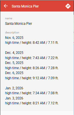
Here’s their times for Santa Monica Pier (good for the entire bay):
Meanwhile…more locally…if you just happen to be on the shore around Santa Monica Bay, especially by Malibu Lagoon, and get some good photos of the inundations, I’d love to post them.
Please include: Whom to credit, location, time, any other interesting stuff.
Contact me, Chuck Almdale, at 818-894-2541 or pollist [AT] verizon [dot] net

Speaking of “Snap the Shore, See the Future”: According to an article I posted over four years ago, beginning next year (2026) we are scheduled for a permanent 4-inch rise in sea level over the next 9.3 years, due to a combination of lunar orbital fluctuations (precession of the moon’s orbital nodes) and continuing (as in it’s been tracked for years) sea level rise due to global warming, glacier and ice cap melting and warming sea water expansion. The next such period will begin 18.6 years after this coming one begins. Next year. Read the article. If your house sticks out over the beach, mark the supporting posts – like you mark your children’s heights on a door frame – and note the change.
And don’t get sucked out to sea by the king tide wave backflow.
Discover more from SANTA MONICA BAY AUDUBON SOCIETY BLOG
Subscribe to get the latest posts sent to your email.


