Free email delivery
Please sign up for email delivery in the subscription area to the right.
No salesman will call, at least not from us. Maybe from someone else.
Bodega Bay Beach Bird Bedlam | Pete Myers
[Posted by Chuck Almdale]
The September 2024 issue of Natural History Magazine (from the American Museum of Natural History in New York City) has a great article on the birds of Bodega Bay, especially those of Limantour Beach on the south shore of Point Reyes Peninsula.
Entitled Bedlam on the Beach by Pete Myers, it documents the birds on the beach, especially in relation to their favorite foods, particularly the Mole (or Sand) Crab, Emerita analoga, a member of the decapod family Hippidae. The mole doesn’t look much like a crab as it lacks claws, and looks more like a brownish-gray olive. Adults range from less than 1″ for males to just under 2″ for females.
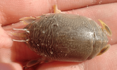
Their unenviable life consists largely of gathering kelp, detritus and plankton with their large antennae during the 5-15 second period the wave rushes out while simultaneously dodging the crowds of shorebirds who rush down behind the retreating wave to gather up this oil and fat-rich prey. The crabs escape capture by burrowing backwards into the churning sand. Somehow they manage to mate and at times millions of their minuscule eggs cover the beach.
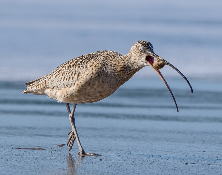
Author Pete Myers has kindly made available over 100 photos of bird action on Limantour Beach. https://www.calidris.photography/Birdscapes/Bedlam-on-the-Beach/i-3qbdVsZ

For example, a Long-billed Curlew about to swallow a Mole Crab. Notice the closed eyes, indicating a happy curlew.
Fortunately, the article was republished with permission in EHN – Environmental Health News, also in September 2024. https://www.ehn.org/shorebird-photography-2669121513.html
Fascinating narration and great photos!
Nelson’s Sparrow at Malibu Lagoon
[Posted by Chuck Almdale]
Here’s a species that doesn’t show up very often at the lagoon. Or anywhere else in Los Angeles County for that matter.

Discovered by Femi Faminu, who often birds with us (and by herself) at the lagoon, except when she thinks it’s going to thundershower. She sent the photo to Kimball Garrett (NHMOLAC, Ret., now of Juniper Hills) who confirmed the species, later posting on our local bird alert listserve LACoBirds https://groups.io/g/LACoBirds/message/4449:
The Nelson’s Sparrow found and photographed by Femi Faminu at Malibu Lagoon this afternoon would appear to be the first record for Los Angeles County since a fall migrant was found by the Southwest Bird Study Club inland at Piute Ponds 25 September 2017. Another fall migrant was found by Chuck Almdale at the Pepperdine University Ponds in Malibu 27 September 1992. Prior to that the only published record for the county was of two birds in January-February 1944 in the Venice area (likely the northern portions of the old Del Rey marshes which were largely obliterated by the construction of Marina del Rey in the very early 1960s). [This, of course, was prior to the split of Nelson’s and Saltmarsh Sparrows, when the combined species was known as the “Sharp-tailed Sparrow.”]
Given what we know of the status of this species in California, it could well have been semi-regular in fall and winter in salt marshes in L. A. county back when such habitat exceeded postage-stamp size. In recent years the species has been seen rarely but with some regularity in estuaries in the other coastal southern California counties. It’s possible the Malibu Lagoon bird will winter there — but of course this species is good at hiding in continuous marsh vegetation and seeing it may depend on tide levels and good fortune.
It’s possible that the bird may stay near the lagoon for a while, but this species are notorious skulkers in marsh vegetation and difficult to find or ID.
Speaking personally – as my name was mentioned above – I do recall seeing the bird at the north end of the easternmost pond on the front lawn of Pepperdine University on a monthly field trip of Santa Monica Bay Audubon, a mere 32 years ago. While I was apparently the first to report this particular sighting (which comes as news to me), I might (or might not) have been the first to identify it, and I definitely did not discover it. Maja Block, former board member and past president of SMBAS found it skulking in a bush near the pond and alerted the rest of us.
Maja and Femi are similar in regards to their preferred birding behavior, which consists largely in wandering off by themselves, often in distant locales, sometimes to discover something wonderful, sometimes to get tangled in the bushes or bang their head on an airplane wing, as Maja did on a trip to Antarctica. When other birders would notice either of them staring fixedly at something through their binoculars, it would often prove worthwhile to go see just what they were looking at.
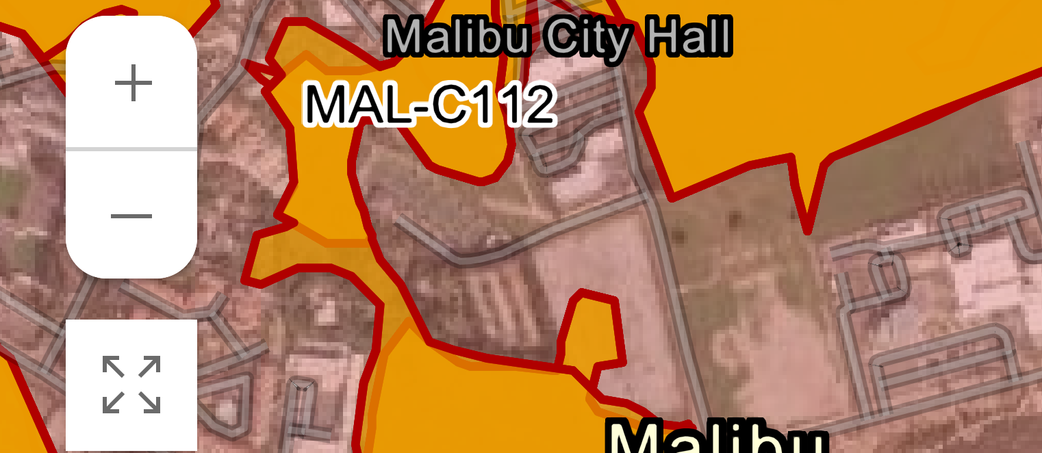
Franklin Fire Map Dec. 2024
[Posted by Chuck Almdale]
Link to map: https://www.fire.ca.gov/incidents/2024/12/9/franklin-fire
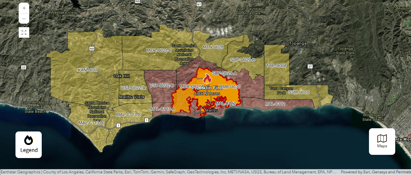
Then you can zoom as close as you want (control+scroll works):
Back Bay Newport: Sun. 15 December, 8:00 AM
The trip is going, reservations not needed.
Starting location is same as last year (see below)
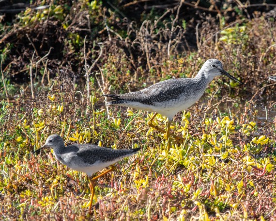
Lesser (L) & Greater (R) Yellowlegs on the pickleweed
(R. Juncosa, Upper Newport Bay 12-8-18)
Back Bay Newport (Upper Newport Bay) can provide great birding when the tides are right. It’s a bit of a drive for us (see below) and the difficulty of finding a weekend day with a super-high tide has occasionally kept us from going in the past. This year, on Sunday Dec. 15 the high tide will be 6.91 ft @ 0810 and low of -1.6 ft @ 1538. [For comparison, last year it was 5.55 ft. @ 0612, and low of 0.18 ft. @ 1318. Highest tide this season is +7.0 ft. on Nov. 16.] Water level will falling during our trip so don’t be late. This isn’t optimal for flushing rails from the reeds, but good for shorebirds and ducks. By the time we get to the upper end of the bay, the tide will have receded and shorebirds should be plentiful. [No promises!]
We will of course search for Sora, Virginia and Ridgway’s Rails, and during that process we will see waterbirds, shorebirds, bushbirds, treebirds, pondbirds, reedbirds, mudflatbirds, sandislandbirds, skybirds and the always-to-be-desired whatnots. [AKA ducks, grebes, waders, sandpipers, gulls, terns and skimmers on the bay and shore, raptors overhead and things in the brush, not necessarily in that order.] I saw my lifer Short-eared Owl here, decades ago, standing on a post among the reeds, and thereafter made the common newbee mistake of expecting to see it on the same post year after year. We had a Bald Eagle the last two years, albeat at a distance. You never know what will be around. We will also search for the endangered California Gnatcatcher at a particular location along the route.

We’ll have lunch (so bring one!) probably at nearby birdy San Joaquin freshwater marsh, and those who wish can do some more birding there. In 2017 we saw a Red-throated Pipit here, a Very Good Bird, and Virginia Rails show up, plus White Pelicans and more whatnots. However, energy remaining, we also make sure to look for anything around; they usually keep a nice stock of interesting birds on hand, scattered around the many birder-sized ponds. They keep a list of sightings outside the bookshop door, AND if you’re looking for a particular bird book (say…Field Guide to Galapagos Birds) they might have it. You could call them: 949-378-6501.
Family guide: We mostly stand around near our cars gawking at the birds, then drive to the next spot and gawk some more. We don’t walk a whole lot. Temps. should be 52-60°, wind 3-5 mph. At San Joaquin Marsh after lunch it’s all walking. Dress in layers.
For future reference: Link to tide chart
Link to December 2023 report.
Driving Time: 50-60 minutes – 48 miles. While there are gas stations in the area (primarily right where you get off the freeway) you could get hung up there while everyone else drives on to the next birding spot to find that über-rarity (or even a mega-tick) which then flies away before you arrive. Don’t let this happen to you! Gas up in advance.
Carpooling Drivers & Riders: If you’re willing to drive others or ride with others, include your contact info, approx. location and drive/ride preference in your reservation to me, and I’ll circulate it to any others similarly interested. If you’re riding, the polite thing is to get yourself to the driver’s starting location rather than try to get them to drive to your house to pick you up. They’re already in for a 2-4 hour drive time for the trip. And riders should inquire of drivers about their face-masking requirements, if any.
Meeting time: 8 am, Sunday 15 December, 2024. Get there early and find the rails and snipes!
Contact: Chuck, no later than Thursday 5 PM 12 December. email misclists [AT] verizon [DOT] net
Food: Bring munchies & liquids and/or lunch. No services next to the bay.
Directions: From the Santa Monica Fwy (I-10)Take San Diego Fwy (I-405) 43 miles south to CA-73. CA-73 south for 2.3 miles [Do not get onto I-55 Costa Mesa Fwy], take exit 15 for JAMBOREE RD and continue on SE BRISTOL ST. about 0.5 mile to JAMBOREE RD. and turn right. Continue south on JAMBOREE 3.1 miles to BACK BAY DR., turn right and continue on BACK BAY Dr. 0.4 miles to the start of MOUNTAINS TO SEA TRAIL HEAD ride/bike one-way road. Continue about 0.1 mile on the ride/bike road to first dirt parking area on left next to the bay. We’ll meet here. Write down these directions and look at the map linked to below!!! Don’t get lost. If you’re significantly late and we’re not at the meeting spot, continue on the ride/bike 15 MPH road. It’s one-way for miles and we’ll be somewhere along it.
Birding Note: Nelson’s Sparrow has been seen by me several times in the past along this first stretch on either side of the road in the reedy areas before the dirt parking area.
Coffee/Bathroom Needs: If you need either before the 8am start, exit CA-73 at Campus Dr./Irvine Ave, the last exit before Jamboree Rd. Continue from exit ramp onto SE Bristol Rd. which has fast food restaurants with bathrooms along the right side. Then continue on Bristol to Jamboree Rd. and to the meeting spot. There are porta-potties on the ride/bike road, but not right at the beginning.
If you get there early, there’s good birding!! right where you’re parked. It doesn’t hurt to get there early and find all the birds for the rest of us, not to mention the one’s that will disappear before we arrive.
Meet at 8:00 a.m. in the parking lot. Leader: Chuck Almdale.
Map to Meeting Place: Back Bay Newport – SE meeting area
Use + and – to zoom in or out, left click and mouse drag to reposition the map.
Directions to lunch @ San Joaquin Marsh
We’ll finish birding Back Bay near the corner of the Mountains-to-the-Sea Trail and EASTBLUFF DRIVE. East on EASTBLUFF DR. and cross JAMBOREE RD. where the road becomes UNIVERSITY DR. Continue under Fwy. #73 and about 1 mile more to CAMPUS DR. Turn left on Campus Dr. & across the creek to the first right, RIPARIAN DRIVE. Turn right & continue north about 1/2 mile to the entrance of SAN JOAQUIN Marsh (home of Sea & Sage Audubon). Turn left and down the little hill to the parking lot. You’ll pass the bookstore on your right and the picnic tables are just beyond the bathroom block. If the parking lot is full, go back up the little hill and park in the large dirt lot below you on the other side, then schlep your lunch over to the picnic tables.
[Chuck Almdale]

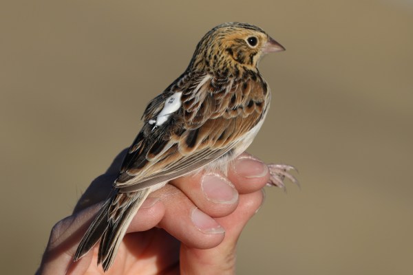
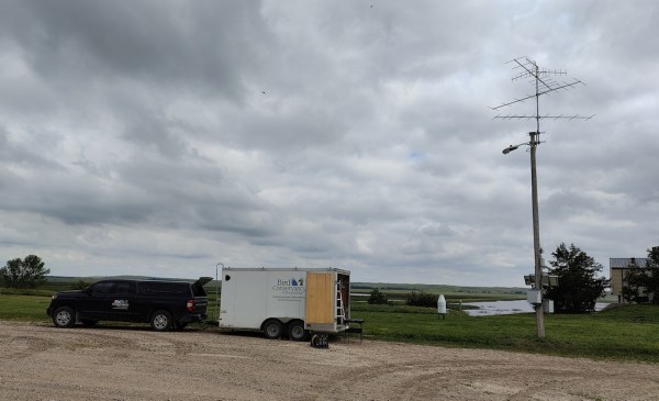
Zoom Recording: The Motus Wildlife Tracking System: Using technology to research grassland birds, with Senior Avian Ecologist Matt Webb.
The recording of this program from 3 December 2024 is now available online
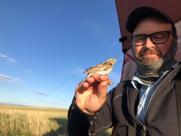
The Motus Wildlife Tracking System: Using technology to research grassland birds, with Senior Avian Ecologist Matt Webb.
The Motus Wildlife Tracking System is a complex and sophisticated system designed to track migrations of birds and other wildlife, and currently has over 1,500 stations worldwide. The Motus (Latin for movement or motion) system uses a variety of transmitters – some as light as .05 grams – which are attached to a variety of migrating wildlife. Information from the receiver stations is fed into large databases which are at the core of a great deal of research on migrations. In this overview and to illustrate how the system actually works, Matt Webb will describe how the Motus system is being used for research on five different species of grassland birds at the Bird Conservancy of the Rockies.
|
Matt Webb is the Senior Avian Ecologist and Motus Wildlife Tracking System Coordinator at the Bird Conservatory of the Rockies in Fort Collins, CO. He was born and raised in Salida, CO. Around age 10, at odds with his preferences, his family moved to the ‘dull’ plains of Northern Colorado. To Matt’s surprise, he fell in love with the endless roll and incredible diversity of the shortgrass prairies. He later spent some time in Pittsburgh, PA, working at the Carnegie Museum of Natural History, the American Bird Conservancy, and the Smithsonian Migratory Bird Center. He holds a Bachelor’s Degree in Wildlife Biology and a Master’s in Conservation Leadership, both received from Colorado State University. When not building automated radio telemetry stations, Matt enjoys mothing, photographing beetles, riding and fixing bicycles, turning over stones, and dragging his family outside at night to watch the International Space Station go by.
Our entire catalog of Zoom recordings is here.


