Bear Divide Bird Migration Count
[Posted by Chuck Almdale]
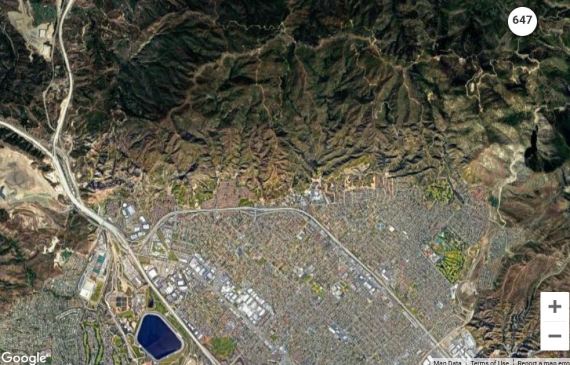
Map 1. Aerial view of north side of San Fernando Valley, about 30 miles NW of downtown Los Angeles. I-5 and I-210 join just north of Van Norman Dam (blue area), then Hwy 14 splits off from I-5 two miles north. Numbered circle upper right is Bear Divide censusing location.
On April 1st I saw this short note on the LACoBirds Listserve.
BEAR DIVIDE LIVE DATA
Hi all-
Now that birds are coming through, we’re streaming records live from Bear Divide at our project website here:
https://dunkadoo.org/explore/bear-divide-migration-count/bdmc-spring-2021
You will be able to see which species are moving and how many, as it happens. This should be live every Thurs-Sat (except tomorrow) until Apr 10, then 5 days a week Apr 10 – May 10. We are still working out some kinks with the technology and internet service up there, but it’s working right now, and hopefully will be live for the rest of the season. — Ryan
Ryan S. Terrill
Postdoctoral Researcher
Moore Lab of Zoology
Occidental College
ryansterrill.com
Bird-chat listserve messages dated April 1st are notoriously unreliable (I know this for a fact, having written some myself), but I took a look at the website link and decided it was on the up-and-up.

Map 2. Bear Divide picnic area locale. Fire Station near center, picnic area upper right. Numbered circle indicates sightings counted at Bear Divide on 8 Apr 2021 as of 4:10pm.
A lot of migrating birds move through Bear Divide — a low point in the East-West San Gabriel mountain range — during springtime. Intrigued, I contacted Terrill, who was kind enough to send me a copy of his grant request to Pasadena Audubon Society. Kudos to Pasadena Audubon who funded his study, which is now operating.
Awareness of Bear Divide as a major migrant highway began in May 2016 when Daniel Maxwell stopped there in the early morning and saw a lot of birds flying by, over the ridge and through the pass.

A few twists in the road to Bear Divide (photo: L. Maya, Dec’17)
The hilly habitat is chaparral mixed with conifers. Locally breeding birds are a mixture of chaparral and montane birds, including Wrentit and Mountain Quail. The saddle is a low pass, about 1700 ft. above sea level, and 710 ft. above nearby Pacoima, through steep hills that quickly rise 1000 ft. to 2700 ft. Birds funnel through this gap, often flying by at birder-eye level. Little Tujunga Rd. approaches from the south, Sand Canyon Road from the north, and Santa Clarita “Truck Trail” from the west. All three meet at the picnic area.
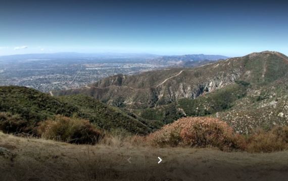
View from Bear Divide Picnic area south towards San Fernando Valley (Photo Jung Yi, Sep’19).
If I were a migrating bird, I’d prefer getting through the mountains on this route rather than through the two noise- and smog-filled freeway-canyons, or by flying thousands of feet higher through any of the other canyons.

Map 3. Bear Divide at upper left red circle. San Gabriel Mtns. present a significant east-west barrier to birds migrating north. Distance between Cajon Pass (I-15) on east and Newhall Pass (I-5) on west is ~60 miles of high mountains. Birds migrating west around this barrier encounter Bear Divide pass ~6 miles east of Newhall Pass.
In 2019, Terrill and others began birding Bear Divide on spring mornings, and again in spring 2020. Unlike most birders they kept track not only of the birds sighted, their numbers and on which days, but of their own efforts. Over those two springs, they amassed over 15,700 observer-hours over 27 days of migration. At least one morning had an estimated “~13,500 individual birds passing through the site.” They concentrated on migrants and did not keep track of locally breeding birds and winter residents.
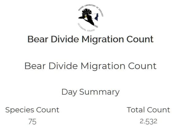
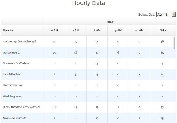
From Bear Divide Migration Count website 8 Apr 2020.
In general, 1-5 birders, sometimes more, would arrive 10-15 minutes before sunrise (sunrise March 15 – 0705, May 15 – 0552). Effort was concentrated at the western saddle, but also at the picnic area, near the fire station and a few adjacent trails and fire breaks (Map 2.), and continued until 0930-1100 depending on conditions. They picked days with predicted favorable weather, avoiding days with fog or low clouds.
They recorded tens of thousands of birds passing through Bear Divide, concentrated during the first three hours after dawn. Migration was at least from mid-March to late May with peak passage around May 1st. As spring progressed, they noticed that migrants passing by later in the season tended to breed farther north.
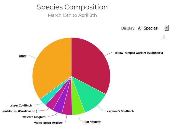
They counted over 75 species. Five warbler species accounted for 25% of the sightings. Ten species were seen only once each.

From Bear Divide Migration Count website 8 Apr 2020.
Birders know all too well that the best time to see birds in in the early morning. But why would migrating passerine birds, who usually fly high and at night, be so common at that time? Terrill thinks they do it primarily to make “course corrections” of the night’s accumulation of errors and variations. He mentions Butterbredt Spring, seventy miles NNE of Bear Divide, as another location where morning flights of migrants occur.
There’s not a lot of information on such morning flight of migrants in the western U.S. This study by Ryan Terrill, Ph.D. can fill in some gaps in our knowledge. Terrill thoughtfully set up a website where local birders can follow along with their findings. He hopes to get hard data on: how many birds, which species and on which dates they pass through. The site may provide an excellent location for graduate research for decades to come.
From Bear Divide Migration Count website 8 Apr 2020.
So if you happen to find yourself at Bear Ridge on an early springtime morning and see people wandering around, wearing binoculars and carrying notepads, now you know what they’re up to. Try not to interfere with their work. It takes concentration and in the time it takes you to ask them a question, a hundred birds could pass by, unidentified and uncounted.
“Birding is hard, nasty, exhausting and dirty work,
— Anonymous Birder —
but someone has to to it.”
Discover more from SANTA MONICA BAY AUDUBON SOCIETY BLOG
Subscribe to get the latest posts sent to your email.


Hello, The enclosed clip is —presumably—from today, as shown on the census webpage. It resembles my backyard, minus the wrentit. So, my question is, how do we know those few birds are migrants? Given that they are flying at birders eye level, couldn’t these birds just be moving around? Thanks for the link. Very interesting. Sent from my iPad
>
LikeLike
Aurelio:
There was NO clip enclosed, so I don’t know what you’re referring to.
You have to know what species migrate through our area versus the local residents and wintering birds.
If you’re looking at White-crowned Sparrows and House Finches, they’re residents and winter visitors. If you’re looking a warblers and flycatchers (except for Black & Say’s Phoebe), they’re migrants. And so on.
LikeLike