Topanga Fire, May 14-18, 2021 | A local view
[Posted by Chuck Almdale | Photographer unknown, submitted by Chris Tosdevin]
Southern California, including the Los Angeles area, has a lot of brush fires. I use “brush fires” advisedly; these fires often involve houses and adjacent trees, but in the lowlands, except around homes, it’s mostly brush. The terrain is extremely rugged and hilly and anyone attempting to clamber through the dense, stiff and thorn-covered “brush” plant community known as “chaparral” quickly learns what a difficult, painful and sometimes lethal undertaking that can be.
I once took a short cut through the chaparral. It took at least 30 minutes to go 30 yards, and the less said about that incident, the better.

Eagle Rock, a local landmark, in Topanga State Park (Photo: park website)
Our wildfires are terrifying events, never to be taken lightly. Humidity is low, brush dry, rainfall rare, access and evacuation difficult, fog and clouds hamper visibility and prevent aerial water drops, and strong winds carry embers across highways, canyons and hillsides, sometimes for miles. Fires are not fun.
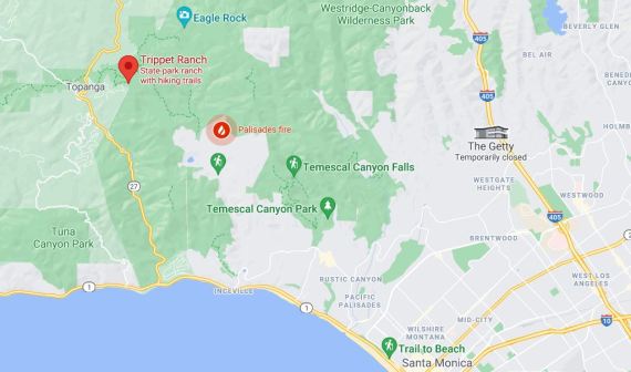
Your basic Google map. The three photos below were taken from Eagle Rock at top of map, looking south.
Last Friday 5-14-21 at ten in the evening, a fire started in Pacific Palisades. By Sunday it was over 1000 acres and burning northward over the hillside towards Topanga Canyon, a rugged rural area. As of this writing, Tuesday afternoon 5-18, the fire is being contained and evacuation alerts have been lifted.
Chris and Ruth Tosdevin, contributors of photos and sighting information to this blog over the past few years, live in Topanga Canyon. They missed our 5-16-21 Malibu Lagoon walk because of fire evacuations alerts. On Monday, May 17, they sent me this brief message in response to my inquiry about their safety. Prior to the pandemic, and for many years, Chris and Ruth led a monthly bird and nature walk from Trippet Ranch (part of Topanga State Park). They are intimately familiar with this area.

Before the fire. View from Trippet Ranch, Topanga State Park, standing east of Eagle Rock, southward towards the fire road/trail, over Pacific Palisades, out to Santa Monica Bay and to the northwest end of Santa Catalina Island, 40 miles away.

Santa Catalina Island.
So far…car packed and waiting for the word to leave—now 48hrs …what a drag! Great way to spend the weekend…situation remains dangerous and we are still on standby!
All depends on wind direction and the marine layer. 🤞
We missed birding this weekend and hope to catch up soon.
Very thoughtful of you to think of us.
Photos below show everything east of the fire road to eagle rock has gone—heartbreaking.
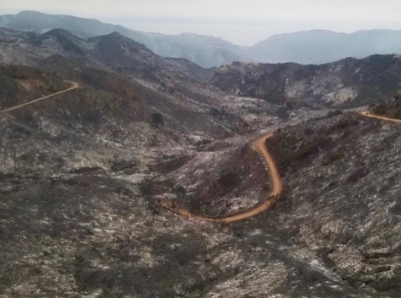
After the fire. Same view, May 17, 2021
So far it’s taken 110 firefighters and water drops from helicopters and airplanes, but the fires have been beaten back and evacuation warnings have been lifted.

After the fire. Same view as above, wider angle. Eagle Rock on right. May 17, 2021
Here’s the timeline from the Los Angeles Fire Dept. slightly shortened:
- Brush Fire 05-14-21 INC#1448 10:02PM. 1807 N Michael Ln; https://bit.ly/3yfAAUe; Pacific Palisades; Fire crews are working to access the remote area where a brush fire has been spotted. Relative humidity is high, with almost no wind. There are currently 60 LAFD firefighters assigned to the incident, as well as a brush response from LA County FD.
- Update Brush Fire 05-14-21 INC#1448 11:59PM. The fire is progressing slowly and has grown to approximately 10 acres.
- Update Brush Fire 05-15-21 INC#1448 01:04AM. LAFD has 72 firefighters on scene, with help from 4 LA County FD hand crews. Fire is approximately 10 acres in heavy brush and steep terrain; no wind and wet/cool conditions. No structures immediately threatened. Crews on standby in a local neighborhood for structure defense in case the conditions change unexpectedly. The fire is not advancing, but will be an extended process to extinguish because of the extremely remote location of the fire, where there are no road or hydrants in steep and rough terrain. LAFD Arson Investigators are on scene investigating.
- Update Brush Fire 05-15-21 INC#1448 06:30AM. Pacific Palisades. This incident initiated last night at 10PM and firefighters worked tirelessly through the night to hold it to approximately 15 acres (difficult to estimate at night due to fire location and it will be re-evaluated after morning briefings). No structures threatened, no evacuations in place and no injuries reported. The weather is cool and wet (with high humidity) and no-to-low winds which helped hold the fire in check within the ‘bowl’ it’s in. Last nights firefighting efforts were primarily from the air with LAFD helicopters making continuous water drops until 5AM, at which time the aircraft needed to undergo maintenance. Air Ops will resume operations today. Firefighters struggled to ascend the hillsides at night to lay in trunk lines (hand lines which serve as a water supply line to the firefighting lines) but due to the extremely steep terrain within the remote canyon and danger of trying to negotiate them in the dark, no existing safe escape routes and the lack of visibility to see the fire behavior (if a change in fire occurs, crews need to be able to move to safe ground prior to being put at risk), they were not able to put the trunk lines in place. A fresh set of fire engines and crews are rotating in this morning to continue the work.
- Update Brush Fire 05-15-21 INC#1448 04:15PM. Pacific Palisades. #PalisadesIC. There is a flare-up within the incident which is creating a large plume residents may see. The estimated size is 100 acres ‘slop over’ (meaning the edge of the fire crossed a control line as opposed to a ‘spot fire’ which is ahead of the fire body). Because the area of land under threat (to the west) is within the SRA (State Responsibility Area) which is a CAL-FIRE (state fire agency) jurisdiction (contracted to LA County Fire) this incident is expanding to a Unified Command with CAL-FIRE, LAFD and LA County Fire working together at incident command (for more information on SRA, https://bit.ly/3yc42dX). Fixed wing aircraft are approved for use as needed, determined by the Incident Command. Ventura Co Fire Dept is also provided a water dropping helicopter. There are no evacuation orders in place. The terrain is very steep and extremely difficult to navigate which hinders ground based firefighting operations. The bulk of the firefighting is air based. There are no injuries reported.
- Update Brush Fire 05-15-21 INC#1448 06:45PM. Pacific Palisades. This incident remains in a Unified Command with LAFD and LA County Fire. The estimated size is well over 200 acres in total. There are three burn areas (for a visual reference, two images will be available on @LAFDTalk on Twitter); the main fire, the original fire from last night and a small spot fire). There are no evacuation orders or structures threatened within the City of Los Angeles. For residents of the County of Los Angeles near this incident, follow @LACoFDPIO on Twitter for all information regarding threats or evacuations. The fire is burning at moderate rate due to the onshore winds. Dozers are working to improve access for firefighters on the ground but much of the area remains inaccessible. This is primarily an air based operation with both fixed wing and rotary working together. The state parks are closing trails in the area because it is unsafe for hikers but can not clear everyone due to the vast area involved. There are no injuries reported.
- Update Brush Fire 05-16-21 INC#1448 07:30AM. Pacific Palisades. Updated acreage and containment numbers are not yet available and will be provided as soon as possible. The weather remained cool and moist overnight which led to calmer fire activity. However, as it warms up today the conditions are expected to change as the vegetation in this area is very dry and has not burned in 50+ years. The onshore winds expected to pick up in the afternoon could push the fire in the NW direction and resources are in place for any structural defense required. The MANDATORY evacuation orders issued yesterday by Los Angeles County Fire Dept remain in effect (estimated to affect 1,000 people) and there is no change to the boundaries provided (follow @lacofdpio on Twitter for maps and orders). The fire cause is deemed to be a ‘suspicious start’ and it remains an open, active investigation (no further details). Helicopters continue to conduct water dropping operations while firefighters are on the ground in the difficult terrain, working to get handlines in place. An operational map of the fire perimeter as of 7AM this morning is available on @LAFDtalk on Twitter and @losangelesfiredepartment on Instagram. No structures have been damaged and no injuries reported. The command post relocated last night to Will Rogers State Beach with the media staging area located north of the lifeguard building. No further details.
- Cause Investigation Update: Brush Fire 05-16-21 INC#1448; 06:00PM. During the course of the investigation, LAFD Arson Investigators and LAPD have aggressively tracked down any and all potential leads. We did have one individual who was detained and released. However, we now have a 2nd individual that is being questioned. The active investigation into the cause of the Palisades fire continues.
- UPDATE Brush Fire 05-17-21 INC#1448 05:00PM. Pacific Palisades. Containment of the fire now stands at 23% while the acreage remains approximately 1325. There are no changes to the Evacuation Warning in the City of Los Angeles (map available at www.lafd.org/news). This has been a team effort across multiple agencies, both in the air and on the ground.
- Update Brush Fire 05-18-21 INC#1448 10:00AM. Containment of the fire now stands at 32% while the acreage has been more accurately updated to 1158 acres. There are no changes to the Evacuation Warning in the City of Los Angeles (map available at www.lafd.org/news). Information on the arrested arson suspect can also be found at lafd.org/news. This has been a team effort across multiple agencies, both in the air and on the ground.
- Update Brush Fire 05-18-21 INC#1448 01:00PM. The Evacuation Warning has been lifted for homes in the City of Los Angeles near the #PalisadesFire as of 1:00 PM today.
More updates, added later, follow below.
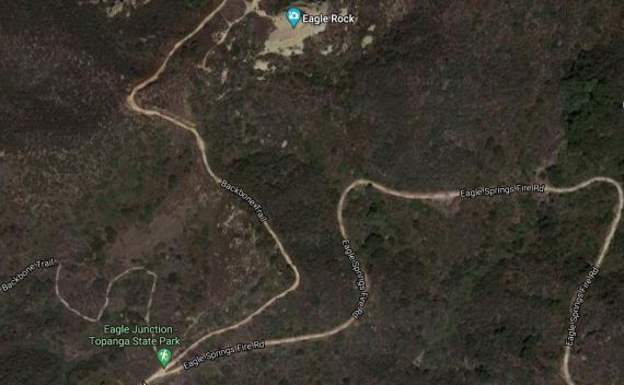
Google Satellite view of now-burnt portion of Topanga State Park.
Final Incident Update Brush Fire 05-26-21 INC#1448 6:00PM. As of 6:00PM today, the #PalisadesFire is 100% contained. Firefighters will remain on-scene patrolling to ensure all hotspots are fully extinguished. Fortunately, due to firefighter’s relentless efforts, no homes were damaged or destroyed, no civilians were injured and we were able to detain the arsonist within just 36 hours from the fire’s start. We would like to thank all of our partners and allied agencies who assisted in a successful conclusion of this incident. For information on how you can be prepared for this year’s fire season LAFD Wildfire Preparedness
Discover more from SANTA MONICA BAY AUDUBON SOCIETY BLOG
Subscribe to get the latest posts sent to your email.


Such a tragic loss of habitat, and during nesting season even more tragic.
LikeLike
Great photos taken on Monday from a fellow birder who lives up in Topanga Canyon.
________________________________
LikeLike
Chuck, thank you for sending this. It’s just awful, a disaster.Best, Enid
LikeLike