It’s as easy as one-three-two! | Horizonal Distance
[By Chuck Almdale]
If you’ve ever wondered how far away was the horizon or an island or a boat, this is for you. A special treat is that there will be formulae, ones you can easily remember and use! Plus a mysterious surprise at the end.
Here are the basic formulae. These will get you close. If you want to get down to inches and millimeters, look elsewhere. These will be useful for approximations like you might do in your head while sitting on the beach watching waves roll in, ships sail by, and birds dive and swim.
Terms:
- d = distance to the horizon
- h = height
- km = kilometer
- nm = nautical mile
- = square root of height (in feet)
Formulae for distance to the horizon
- Miles and Feet: d (miles) = 1.22
- Kilometers and Meters: d (km) = 3.57
- Nautical Miles and Feet: d (nm) = 1.17
Some background on the nautical mile
A nautical mile is based on Earth’s geometry rather than our human steps, and is about 15% longer than a land mile. It equals one minute of latitude (1/60th of a degree) along a meridian (north-south lines on the earth’s surface connecting north pole to south pole). The nautical mile measures approximately (≈) 6,076 feet (≈1,852 meters). A land mile is 5,280 feet, so the nautical mile is ≈15.08% longer. When plotting positions and routes on marine or aviation charts, it’s far more practical to use a distance unit tied directly to degrees of latitude than to the length of some ancient person’s foot. Each degree of latitude equals exactly 60 nautical miles rather than ≈69.045 land miles. Thus the circumference of the earth through the poles is 60 nm x 360 degrees or 21,600 nm. The earth’s circumference 24,860 land miles through the poles, but 24,901 land miles at the equator (thanks, Google!), as the earth is not a perfect sphere but an oblate spheroid, flattened at the poles. And 24,860 land miles is very close to:
21,600 nm x 115.08% = 24,857 land miles.
By the way, we’ve been truncating the actual constants in these calculations. There’s no point in using a number with more than two decimal places when estimating in your head, and getting to something you can do in your head is one of the goals of this article.
Atmospheric Refraction
A complicating factor is that our atmosphere bends (refracts) light downward, enabling us to see slightly around the curve of the Earth, extending our actual visual horizon by about 8% to 10%. If you’ve ever looked at a table of sunrises, sunsets and lengths of daylight and they don’t seem to work out quite right because there seems to be an extra few minutes of daylight, that’s because of atmospheric refraction. We can still see the sun for about two to three minutes after it actually sets, as well as before it rises. [Keep this in mind when looking for the green flash at sunset, which is a real thing, by the way, not a myth. I’ve seen it.] Thus every “day” is four to six minutes longer than it actually is. In a manner of speaking.
This means the formula for what we are actually seeing needs to be slightly adjusted for this 8-10% horizon extension due to atmospheric refraction.
Formulae adjusted for Atmospheric Refraction
- Miles and Feet: d (miles) = 1.32
- Kilometers and Meters: d (km) = 3.86
- Nautical Miles and Feet: d (nm) = 1.26
All calculations from here on will include this ≈8% adjustment for atmospheric refraction.
Now that that’s settled, let’s do something with this.
A Digression
This posting, by the way, arises out of our frequent trips to Malibu Lagoon. Many a time I’ve stood on the beach and on a clear day seen Palos Verdes Peninsula, Santa Catalina Island and even Santiago Peak in Orange County, seventy miles away, but not Santa Barbara Island. Yet I’ve found that if you drive up one of the roads leading north towards one or another of the various canyons, you can see Santa Barbara Island when you get sufficiently elevated. It’s “come around” the curvature of the earth, in a manner of speaking. I wanted to know a bit more about this business of “how far is the horizon.” Why you can’t actually ever get to the horizon is a matter for another, more fruitlessly philosophical discussion.
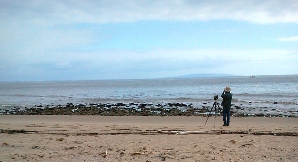
As square roots are involved, and I want to keep the math close to something you can do in your head, we’re going to play around with our positions.
Distance to the horizon
Let’s assume we’re sitting on the beach, not far above the water line. When I sit down, my eyes are 30 inches above the ground, so I’m going to sit 18 inches above the water line, putting my eyes at 48 inches or 4 feet above the water level. The calculation, including atmospheric refraction (as are all following calculations), will now be:
Elevation 4 feet above sea level:
d (miles) = 1.32
d = 1.32 = 1.32 x 2 = 2.64 miles to the horizon.
There! That’s easy. It’s as easy as one-three-two!
Here’s a mnemonic that’s also a little ditty. The tune is from the 1965 rock ‘n’ roll song, “1 – 2 – 3”, a hit for “Blue-eyed Soul” singer Len Barry (on YouTube) who also co-wrote it.
1 – 3 – 2
times the square root of your
height above the blue
that’s the distance to
the horizon (yeah, yeah, yeah)
Let’s add a few feet and see what happens by standing up and go a little up the beach slope so our eyes are now 9 ft. above the water. Our formula is now:
Elevation 9 feet above sea level:
d (miles) = 1.32
d = 1.32 = 1.32 x 3 = 3.96 miles to the horizon, or ≈4 miles.
Simply by standing up and taking a few steps, we added 1.3 miles to the distance to the horizon. And…we may now suspect (correctly) that every time you elevate yourself to the next integer square (e.g. 1, 4, 9, 16, 25, 36…) your horizon gets 1.32 miles farther away, or 4/3rds of a mile if you don’t mind a little rounding..
If we climb up to the lifeguard station not far away where we’ll be (maybe) 25 feet above the water, the formula is now:
Elevation 25 feet above sea level:
d (miles) = 1.32
d = 1.32 = 1.32 x 5 = 6.6 miles to the horizon
Tell that to the lifeguard and maybe he’ll let you leave peacefully.
Now drive up the canyon road until you’re 400 ft above sea level and look out to sea. [Every car has a built-in altimeter these days, right?] The formula is now:
Elevation 400 feet above sea level:
d (miles) = 1.32
d = 1.32 = 1.32 x 20 = 26.4 miles to the horizon. [Isn’t this easy when you pick an elevation with a whole number for its square root?]
Where is Santa Barbara Island? Can you see it from the mainland at 400 feet above sea level?
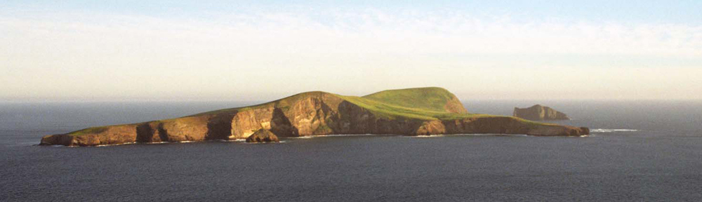
(Santa Cruz Island Foundation, Bill Dewey photo)
Santa Barbara Island
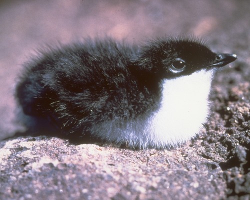
Santa Barbara Island is a small island, just a hair over one square mile (1.014 sq.mi.). It’s part of Channel Islands National Park (Link), uninhabited by humans except a lucky park ranger and visiting campers or boaters. In addition to large rookeries of of Sea Lion, Harbor Seal and Northern Elephant Seal, it has numerous nesting sea birds including the world’s largest breeding colony of Scripp’s (formerly Xantus’) Murrelet Synthliboramphus scrippsi. These birds nest in cracks, caves and holes in the extensive cliff faces, and the adults return to their nests only at night.
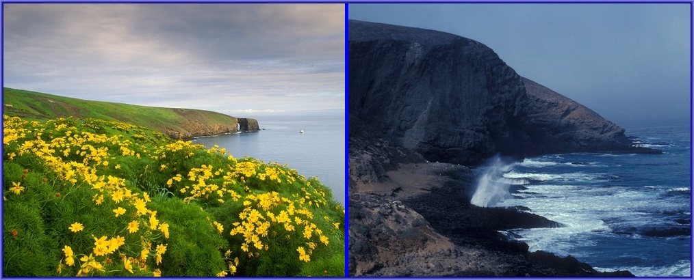
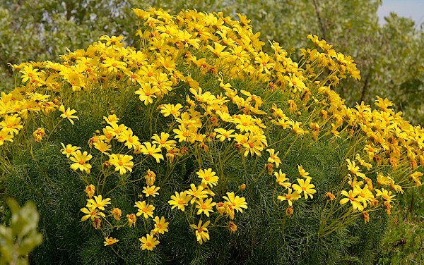
It’s also the homeland of the Giant Coriopsis, Leptosyne gigantea, a plant that apparently made it’s own way to the mainland near Mugu Rock, and was also introduced by California State Parks biologists to Malibu Lagoon State Park in 2013, where it puts out many beautiful yellow daisy-like flowers in late winter and early spring. The island is not a volcano per se (there’s no cone or caldera), but is composed of volcanic basalts from the Miocene epoch (23 to 5.3 million years ago), mixed with marine sediments and covered with a thin layer of soil. The tallest peak, which is adjacent to a really steep cliff dropping off almost directly into the sea, is 634 ft. Signal Hill. And the island is 43.6 miles south-southwest from the beach at Malibu. Remember both those numbers, which are conveniently and fortuitously in opposite order.
Just as the horizon gets farther away from you as you rise in altitude, you can see the top of something whose base is beyond the horizon and out-of-sight, such as the mast or smokestack of a ship sailing towards you. [This is what flat earth advocates don’t seem to be able to grasp.] Standing at sea level and seeing the top of a 634 ft. mountain whose base is beyond the horizon, is the same as standing on that mountaintop and seeing (with a very good telescope) yourself standing at sea level, in a manner of speaking. And you can use the 1-3-2 formula to calculate the distance.
First, let’s calculate the altitude you’d need to be at to see the base of Santa Barbara Island. This time we know the distance, but not the altitude, so we must reconfigure the formula to solve for altitude.
d (miles) = 1.32 or = d(miles) / 1.32
= 43.6 miles / 1.32 = 33.03
h (feet) = (33.03)2 = 1091 feet
If you were on a cliff 1091 ft high at the shoreline of Malibu, you’d be able to see the base of Santa Barbara Island. But how about seeing only the top half of the island, or 317 ft. altitude at 43.6 miles distance, enough to let you say, “Hey. There’s Santa Barbara Island!” How high must you drive up a local road to see the top half of the island? This is slightly more complex.
How high must we be to see the top half of Santa Barbara Island?
First we calculate the distance to the horizon from altitude 317 ft. on Santa Barbara Island, or halfway up Signal Peak.
d (miles) = 1.32 = 1.32 = 1.32 x 17.804 ≈ 23.50 miles.
That is (accidentally) very close to half the 43.6 mile distance to the Malibu coast. However, I’m going to add a little to that 43.6 miles distance because you will, in fact, have to drive a little distance inland in order to gain a few hundred feet in altitude, so I’m changing that to 45 miles.
Therefore the distance from Malibu to the horizon needs to be:
45 miles – 23.50 miles = 21.5 miles.
You should be able to guess that the altitude we’ll need is going to be a bit less than the 317 ft. we more-or-less arbitrarily chose for Santa Barbara Island, simply because 21.5 is slightly less than half the total distance.
d (miles) = 1.32 or = d(miles) / 1.32
= 21.5 miles / 1.32 ≈ 16.288
h (feet) = (16.288)2 ≈ 265.30 ft. altitude
Great! In order to see the top half of Santa Barbara Island lying 45 miles away and over the horizon, we need climb only 265 ft. in altitude above sea level. That’s easy! Just drive up Malibu Canyon/Las Virgenes Rd., passing the entrance to Pepperdine University on your left, and up to the property of Malibu Pacific Church on the seaward side of the road and pull into their ample parking lot. You’re now at 89 meters or 292 ft above sea level. If it’s a clear day (don’t count on it!), you can see the top half of Santa Barbara Island from here***. Nice view. Santa Catalina Island is easy to see as are Palos Verdes Peninsula and other mountains to the south. Good place to put a church named Malibu Pacific Church. [They could even add “with a great view of Santa Barbara Island” to their name. Just a suggestion.]

While you’re standing there, after having gone through these various mathematical calculations, you might think about Saint Barbara herself. She is now a very popular saint with many towns and locations scattered around the world named after her, but originally she was an early Christian Syrian Greek martyr, born in the 2nd century CE in either Heliopolis, Phoenicia or Nicomedia, in now-Turkey just south of the Black Sea. Like Rapunzel with the long hair – and it’s conceivable that she is the origin of the Rapunzel fairy tale – her father was very protective and locked her away in a tower with a high window while he set about finding her a suitable husband. She wasn’t interested in his plan for the rest of her life and instead converted to Christianity for which she was tortured and executed by the local authorities (who were not yet Christians), despite the many reports of miracles surrounding her. She is now the patron saint of – of all things – people who work with explosives such as artillerymen, firefighters and miners, but also – tada! – mathematicians, even amateur and lazy mathematicians. Due to her affinity with miners, she should also be the patron saint of all birds that live in burrows and caves, such as the Scripp’s Murrelet, now breeding in great numbers on her namesake island.
Summing up
We ran through a series of formulas. Here are the important ones for non-mariners in the U.S., meaning that they use land miles and feet.
Distance given altitude without atmospheric refraction:
d (miles) = 1.22
Distance given altitude with atmospheric refraction
d (miles) = 1.32
Altitude given distance with atmospheric refraction
h (feet) = (d(miles)/1.32) 2
Calculating altitude of your own location 1 given total distance and altitude at location 2
(e.g. Your elevation necessary to see something whose base is beyond the horizon.)
Step 1. Calculate distance to horizon from location 2 altitude
d2 (miles) = 1.32
Step 2. Calculate distance from horizon to location 1.
d1 = total distance – d2
Step 3. Calculate location 1 altitude necessary to see d2
h1 (feet) = (d1(miles) / 1.32) 2
Using our “seeing Santa Barbara Is. from Malibu) example, we needed to know the distance (45 miles) between the island and a big hill on the Malibu coast. Then we needed to pick a portion of the island we thought large enough to be visible if 45 miles away, and we settled upon the top half of the height of the island (317 ft). Therefore:
D2 (miles) = 1.32 = 1.32 = 1.32 x 17.804 ≈ 23.50 miles.
d1 (miles) = 45 – 23.50 = 21.50 miles
h1 (feet) = (d1(miles) / 1.32) 2 = (21.5 / 1.32) 2 = (16.288) 2 ≈ 265 ft.
Admission: I’m not wonderful at calculating square roots out to the 2nd decimal – or to any decimal, for that matter – in my head. I prefer using whole numbers and rounding, so I created a chart. Let’s rerun these calculations picking squares and square roots approximate to our problem.
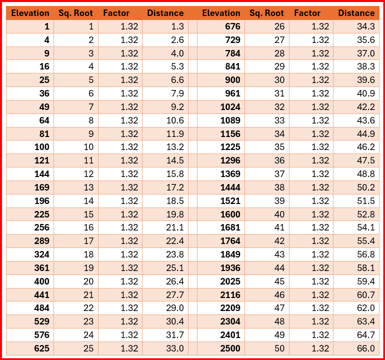
I happened to have memorized a lot of these squares ages ago, probably while waiting in the principal’s anteroom waiting for my weekly reprimand, but with this chart, we’ll pick 324 as “close enough” to our Santa Barbara Is. altitude of 317 ft., which was arbitrarily selected anyway. So now we calculate:
Step 1. d2 (miles) = 1.22 = 1.22 = 1 1/3rd *x 18 = 24
Step 2. d2 (miles) = 45 – 24 = 21** miles
**Let’s just round that 21 miles up to 21 1/3rd miles (you’ll see why), and likewise notice that I rounded our 1.32 to 1 1/3rd, which, when multiplied times 18 gave us a nice round whole number of 24. Now we plunk 21 1/3rd into our step three formula.
Step 3. H1 (feet) = (d1(miles) / 1.32) 2 = (21 1/3rd / 1 1/3rd) 2 ≈ (16) 2 = 256 ft.
Please note that 21 1/3 is evenly divisible by 1 1/3, arriving at exactly 16. That’s why we “rounded” to it.
Our previously calculated altitude using decimal points and calculators at Malibu was 265 ft. This time, rounding when convenient and calculating in our head(s), we got 256 ft, or 3% less. Not worth worrying about unless you’re trying to hit the moon with a rocket. So…with one given distance (43.6 miles) and one given altitude (634 ft.) and intelligent “rounding” wherever convenient and advantageous, we arrived at a figure within 5% of error, acceptable in most scientific journals, and certainly good enough for someone lying on the beach admiring the waves and daydreaming. And it’s not like anyone can naked-eye-view a mountain 45 miles away and tell whether they’re seeing 300 feet or 400 feet of the mountaintop.
Note***: The sky hasn’t been sufficiently clear since I wrote this so I haven’t actually confirmed the visibility of the island from this exact location.
Part II: Square Artifacts
In the process of playing around with squares and square roots for this article, I noticed a few oddities that I’d never seen before. I don’t think they’re terrifically important, just odd and interesting. If you’re tired of these formulas and numbers, go ahead and quit now. But you’ll miss a couple of things you might find interesting as well as not finding out about that mysterious surprise I promised at the beginning.
When you looked at the chart above, you likely noticed that the elevations displayed all have whole number square roots. That’s why they were selected, so we could have roots without decimals, making it easier to do the math in your head. But see if they’re anything odd about the spaces between the sequential elevation numbers. Yes…go ahead and take a minute to calculate some of the numerical gaps in the sequence of elevations.
There are two oddities.
- All the gaps are odd numbers: 1, 3, 5, 7, 9…..
- The gaps between consecutive elevations are consecutive odd numbers: 11, 13, 15, 17, 19….
You can chart this out as far as you wish and it continues forever (I stopped somewhere short of infinity). We can conclude that every odd integer in the universe is the difference between two consecutive squares of integers. I’d never noticed that before. Had you?
There’s a third oddity. I created another table to spell this out more clearly.
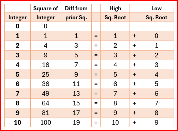
As succinctly as I can put it, each difference between consecutive squares is the sum of the root of that square and the root of the preceding square. Thus 19 is the difference between 100 and 81, whose square roots are respectively 10 and 9, and 10+9 = 19. And this holds true as high as you want to go. There’s a very rational reason why this is true, but I’ll let you work that out for yourself.
As mentioned above, I can’t see that this is terrifically important, but I find it interesting. And it can be useful if you do things like pass the time doing squares and square roots in your head while you’re sitting in the dentist’s chair, waiting for the Novocaine to kick in.
Let’s say that you know the square of 20 is 400, but not the squares of 19 or 21. You can use this peculiarity of the addition of the roots to quickly figure it out.
Let n = 20
Square of (n+1) = square of n + n + (n+1), or 212 = 400 + 20 + 21 = 441
Square of (n-1) = square of n – n – ( n-1), or 192 = 400 – 20 – (20-1) = 400-20-19 =361
This can be made shorter:
Square of (n+1) = n2 + 2n + 1 or 202 + 40 + 1 = 441
Square of (n-1) = n2 – 2n + 1, or 192 = 202 – 40 + 1 = 361
Check the chart farther above. You’ll see that this works for all the numbers.
If you figure out something more useful to do with this, let me know. I’d be interested.
Addendum Annotation
That equation just above might have looked a little familiar.
Square of (n+1) = n2 + 2n + 1 or
(n+1)2 = n2 + 2n + 1
It ought to, as we all studied these things in high school math, then known as quadratic equations, although they looked a little different. Some of us complained, “What am I learning this for? I’m never going to use this anywhere!” Well, now you get to use it somewhere, like lying on the beach, wondering how high you have to be to see Santa Barbara Island. Let’s change it to look familiar, and then we’ll solve the equation.
(n+1)2 = n2 + 2n + 1 is the same as (x+1)2 = x2 + 2x + 1
Let x = 20. Then (x+1) = 21 and (x-1) = 19
So let’s find the squares of 19 and 21 as we did above.
Square of 19
(x-1)2 = x2 – 2x + 1
(20-1)2 = 202 – 2×20 + 1 = 400-40+1 = 361
Square of 21
(x+1)2 = x2 + 2x + 1
(20+1)2 = 202 + 2×20 + 1 = 400+40+1 = 441
Check that against the top chart above. You’ll see these results are correct.
This also works for distances between the square roots farther than 1. Let’s find the squares of 17 and 23, each is a distance of 3 from 20.
Square of 17
(x-3)2 = (x-3) x (x-3) = x2 -3x – 3x + 9 = x2 – 6x + 9
(20-3)2 = 202 – 6×20 + 1 = 400 – 120 + 9 = 289
Square of 23
(x+3)2 = x2 + 3x + 3x + 9 = x2 + 6x + 9
(20+3)2 = 202 + 6×20 + 9 = 400 + 120 +9 = 529
Voilà! You’ve now used a quadratic equation for a real purpose, perhaps for the first time in your life. Tell your grandkids, or grandparents, or both, whatever your situation. [That, by the way, was your mysterious surprise. Thrilling, wasn’t it?]
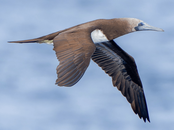
But next time you go to the beach, keep an eye our for the Cocos Booby and those obscure tropical storm-petrels and offshore murrelets and auklets, now passing our shores with greater frequency due to climate change, heat bubbles, Kelvin Waves and El Niño effects. Don’t get lost in the numbers.
Discover more from SANTA MONICA BAY AUDUBON SOCIETY BLOG
Subscribe to get the latest posts sent to your email.