Local ocean news of interest
[Posted by Chuck Almdale]
This is a bit rushed, so I’ll minimize my comments.
1. The Malibu Times has an interesting update on local ocean, weather, erosion problems and is holding discussions and workshops about what’s coming and what to do. Even if you don’t live in Malibu Beach (I don’t), it’s interesting to read.
Malibu races to repair coastal damage and clear creeks ahead of winter storms
By Barbara Burke · October 1, 2026
King tides and Kelvin waves are expected to add 6-12 inches to the base sea levels. Link
Sample excerpt:
State Parks officials have completed emergency repairs to Malibu Pier. They replaced and repaired deteriorating and missing pilings both under the water and above the water. The end of the Pier remains closed, as it has since January 2025 after the Palisades Fire, pending completion of a full-scale rehabilitation project that is projected to take approximately 18 months. State Parks awarded a contract for the long-term repairs that will include a structural overhaul of the pier targeting deep-water substructure, load-bearing pilings and deck framing to support the ocean end of the pier, according to a statement issued by State Parks on Sept. 18. The Malibu Farm Pier Cafe at the far end of the pier remains closed, while the Ranch at the Pier retail store has temporarily relocated to the Malibu Cabana near the Pier’s entrance. Readers can send questions and concerns to angelesinfo@parks.ca.gov and can find updates on the Malibu Lagoon State Beach webpage.
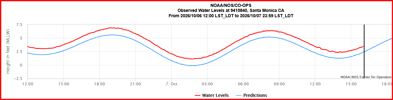
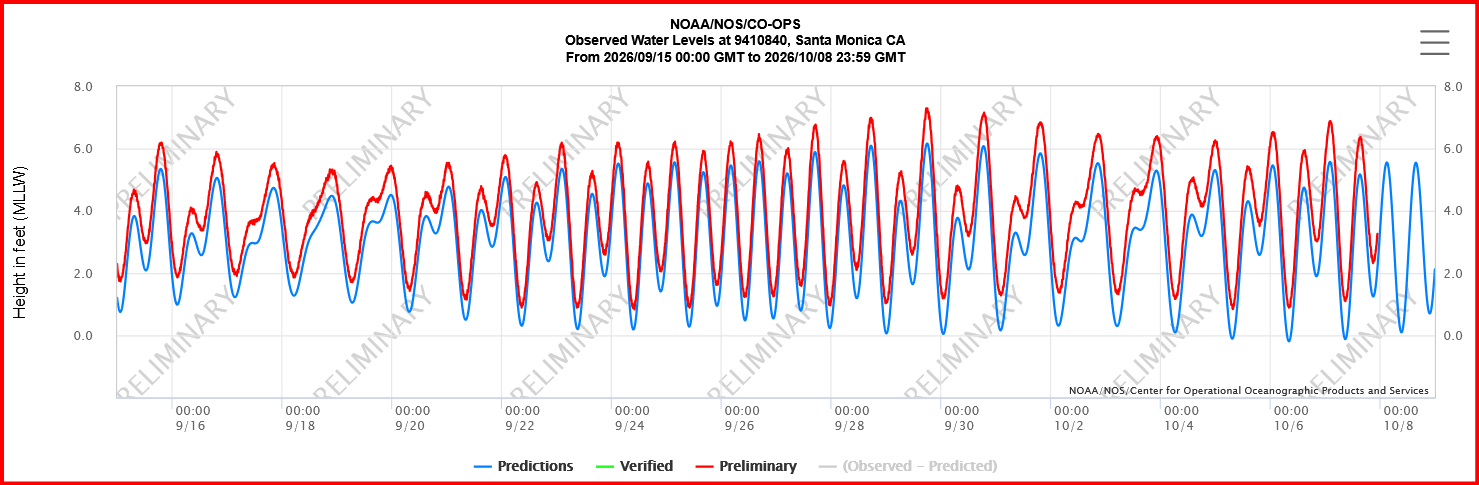
2. If you use the NOAA tidal charts, be aware that their predictions and past information are based entirely on the well-known and highly reliable astronomical factors. The do not make adjustments for actual weather, storms, kelvin waves or anything else. The charts pasted in below shows this difference between prediction and fact; blue (lower) is prediction, red (upper) is actually observed. These are for NOAA station 9410840 located at the seaward end of Santa Monica Pier. For today the difference appears to be about a foot. Link
aaa
3. Here’s an older Malibu Times report about the high surf that hit them last week. Link
High surf, rip currents and elevated tides threaten Malibu beaches through Tuesday
By The Malibu Times·September 28, 2026
City warns hazardous conditions and erosion could continue through Wednesday as hurricane swells coincide with high tides and an already vulnerable shoreline
4. Google AI can be quite informative on these El Niño and Kelvin Wave matters. For example, I asked: “How far north has the Kelvin wave gotten? When might we expect to see the effect at Malibu Beach?“
The reply ( all those little numbers in brackets are web links):
The coastally trapped Kelvin wave has officially made landfall in Southern California and is actively pushing northward past Los Angeles. [1, 2]
Satellite measurements and regional tide gauges show that the slow-moving pulse of warm, subsurface water has already moved up from Mexico and Baja California. It is currently traveling up the California coast at about 6 miles per hour (150 miles per day), with its elevated effects expected to reach all the way up to Oregon and Washington through the rest of October. [1, 2, 3]
The active impacts and timeline for Malibu Beach reveal several critical factors:
When to Expect the Effect at Malibu
The effect is happening right now. In early October, NOAA tide gauges along the Los Angeles coastline—including the NOAA Santa Monica Pier Station just south of Malibu—are already logging a slow, steady increase in background sea levels. [1, 2]
- Current Anomaly: The ocean baseline off Malibu is currently running about 4 inches (~10 cm) above normal.
- Mid-to-Late October Peak: As the heart of this specific planetary wave pulse centers over the region mid-month, the background sea-level anomaly is projected to peak at 6 to 12 inches above normal. [1, 2]
The Risk Matrix: Flooding & Overwash
Because a Kelvin wave is an invisible, deep-ocean feature rather than a crashing tidal wave, it does not cause immediate flooding on its own. Instead, it acts like a temporary, months-long stage rise. [1, 2, 3]
The genuine threat of overwash and flooding to Malibu’s low-lying homes and the Pacific Coast Highway occurs when this elevated baseline overlaps with secondary factors: [1]
- Compounding Storm Swells (Immediate Concern): Residual swells from recent Eastern Pacific tropical systems (including Hurricanes Polo and Odalys) have been pushing 7-foot wave heights into south-facing Southern California beaches. When 7-foot surf rides on top of an ocean that is already 4–6 inches higher than the chart dictates, wave run-up cuts significantly farther into the sand, drastically accelerating beach erosion. [1, 2]
- The Upcoming King Tides (Late Autumn Threat): The peak danger window for structural overwash will arrive between November and January. This is when the maximum baseline elevation from the Kelvin wave will perfectly align with the year’s highest astronomical King Tides. [1]
Caltrans and local Malibu agencies have already initiated emergency beachfront reinforcements and creek clearing to prepare for this multi-month period of high coastal vulnerability. [1]
If you are tracking a specific property or section of the highway, would you like to look up the FEMA Flood Zone designation for that stretch of the Malibu coast, or should we check the specific peak high-tide times for the upcoming week? [1, 2]
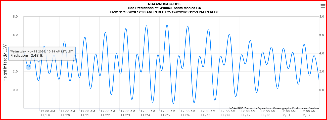
5. If you want to see when the King Tides will arrive, check the NOAA site. Here’s a chart for the first King Tides in November for the Santa Monica pier site. Link
The monthly cycle is 29.5 days long. The highest tide in Nov. is on 11/25, so the highest in Dec. will be on 12/24 or 25, and so on, endlessly. Merry Christmas to all of you. Just remember that storms and Kelvin waves are not included in these predictions.
6. Along with the warm water from the tropics may be tropical sea creatures and birds. If you go and sit at the end of one of the piers for several hours, you might see some interesting birds: boobies, frigatebirds, various auks and storm petrals and shearwaters, maybe even a tropicbird. (I saw one on the way to Santa Barbara Island many decades ago, so they do get up here.) Check the water now and then for sharks, jellyfish and other denizens of the sea swimming by.
Discover more from SANTA MONICA BAY AUDUBON SOCIETY BLOG
Subscribe to get the latest posts sent to your email.