Water I: rainfall, watershed, creek, lagoon, beach, ocean
[By Chuck Almdale]
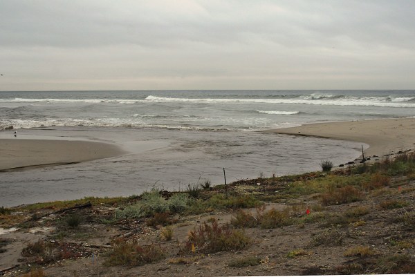
It’s long been my impression that it takes about ½ inch of steady rain in Malibu to send enough water down Malibu Creek to blow through the beach directly across from the Pacific Coast Highway (PCH) bridge. Several days of soft rain can cause lagoon water level to slowly rise until it breaches at the lowest point in the beach; the outflow then erodes its own channel and velocity of the outflow depends upon the differential of lagoon level to sea level. The greater the differential of water level, lagoon to sea, the faster the flow and greater the erosion.
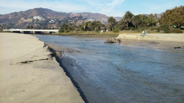
During or after a heavy rain, the breach usually appears directly south of the PCH bridge
where the force of the flow impacts and overwhelms the beach.
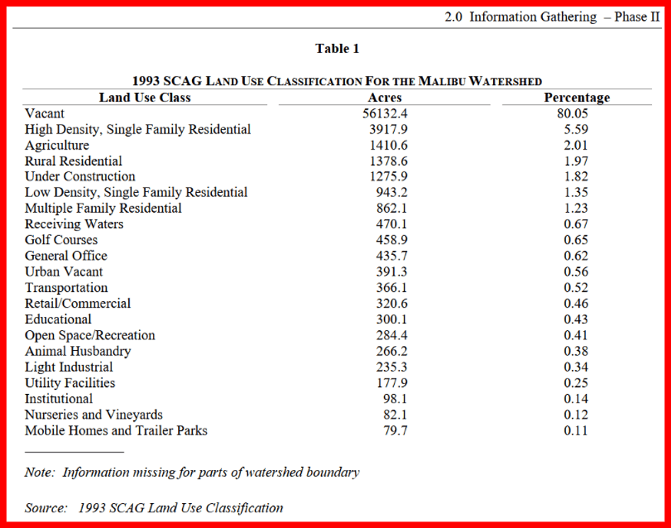
The amount of creek water produced by a rainfall is mostly a matter of multiplication, based primarily upon watershed size. The Malibu Creek watershed is approximately 109 square miles, but according to the following report (pg 26, table 1 included at bottom), it is 69,887.2 acres:
Watershed Management Area Plan for the Malibu Creek Watershed
Prepared for: Las Virgenes Malibu Conejo Council of Governments
Prepared by: PCR Services Corporation, January 2001
https://pw.lacounty.gov/wmd/watershed/mc/wmap.pdf
Several maps and charts from this watershed report have included in this posting. It is recommended reading for those especially interested in Malibu creek, lagoon, or watershed.
There are other reports pertaining to watershed planning, including:
Link to Enhanced Watershed Management Program for Malibu Creek Watershed, Draft Report, June 2015.
Link to U.S. Army Corp of Engineers November 2020 report on Rindge Dam removal and allied watershed topics; Final Integrated Feasibility Report (IFR) with Environmental Impact Statement/ Environmental Impact Report and Appendices
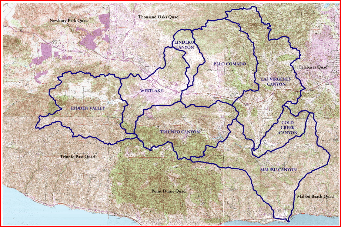
Map of Malibu watershed from the Watershed Management Area Plan report, page 13. Malibu Lagoon south of Pacific Coast Hwy is the tiny bump in the lower right corner.
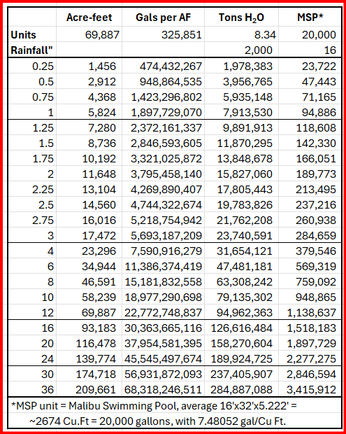
Using the 69,887 acreage from the report, and several units gleaned from other sources, I created the following table of creek water correlating rainfall, acre-feet, gallons, tons and MSP* units of water.
For example, if there is an average of 0.5 inch of rainfall in the watershed, that amounts to 2,912 acre-feet of water, totaling 948,864,535 gallons of water weighing a total of 3,956,765 tons and equivalent to 47,443 MSPs of water. The MSP unit is explained below. It doesn’t take much rain to produce a tremendous amount of water with many tons of force.
Even a brief thunderstorm can send a cumulative weight of millions of tons of water into the lagoon and up, over and through the beach.
If any of the above figures are unclear, the information below is supplied as support and as future reference.
The MSP unit
The average size of a residential inground swimming pool in California—including areas like Malibu—is 16’ by 32’. When filled to a typical depth of 5.222 ft, it holds exactly 20,000 gallons of water. I propose that we call this 20,000-gallon unit the MSP for “Malibu Swimming Pool.” It paints an interesting mental picture when you tell someone that if it rains only one inch in Malibu, that is the equivalent of almost 100,000 Malibu Swimming Pools worth of water coming down the creek and blowing through the beach. Even a mere ¼-inch of rainfall is equivalent to almost 25,000 MSPs.
The primary units used are:
Malibu Creek watershed area: ≈109 sq. mi.
Acres per square mile: 640
Watershed area: 69,887 acres
Cubic feet per acre-foot: 43,560 sq.ft.
Gallons per cubic foot: 7.4805 gallons
Weight of water per gallon: 8.34 lbs
Weight of water per cubic foot: 62.4 lbs
MSP gallons: 20,000
Additional derivative units are listed at the bottom of this article.
A short gallery of beach and tide photos
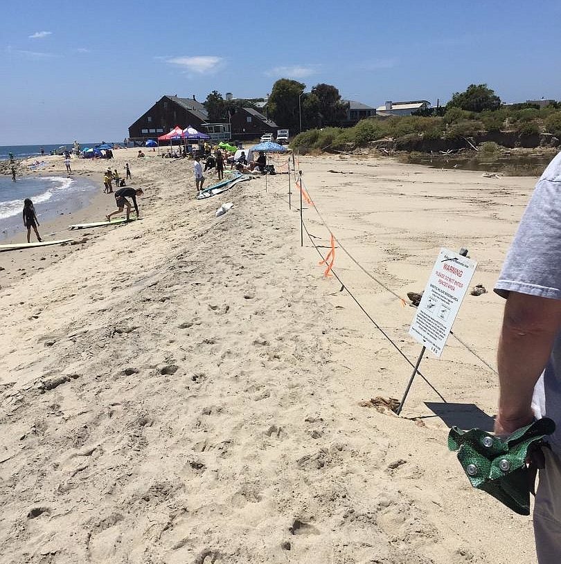
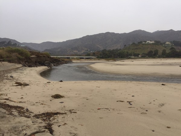
As eroded as the beach above was in July 2019, it was far worse in September 2026 as seen below. The lifeguard station and brushy cliff are in the same location in both photos.
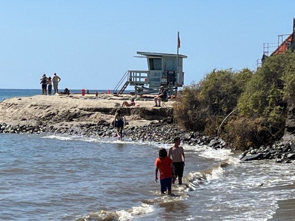
(Grace Murayama, Sep 18 2026)
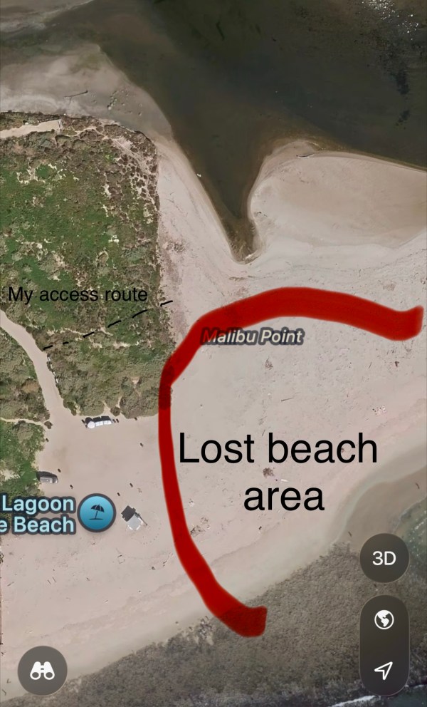
The aerial photo below was posted by someone from either State Parks or Surfrider’s Foundation during late September or October 2026 at the lagoon parking lot entrance to illustrate why beach access was limited. This accurately replicates what is shown (missing) in the photo above. Lagoon is at top, ocean at bottom.
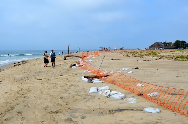
We often get very high tides in June, frequently over 6 feet. In June 2017 10-15 pairs of Least Terns nested between the lagoon and sea for the first time in many decades. Their nests were wiped out on June 23 by a 7.03 ft. high tide at 9:19 pm when waves swept completely across the beach and into the lagoon. As this occurred at night, no one was there to witness it. Only one chick survived. Dozens of sandbags were put in place to protect the nesting area from waves. The bags were, however, put on end in a single row against the plastic fence, and the waves brought by the next high tide knocked all of them over, frequently taking the fence with them. They have to be laid flat and stacked up, which takes a great many more bags.
The terns began re-nesting immediately and this time fortune favored the terns. By the time the July tides of 6.42 to 6.80 ft. arrived on July 20-24, the chicks were more capable of surviving, and the lower tides did not completely cross the beach. On our monthly bird walk of July 2023 we counted a total of 30 adults and chicks, including a few birds still sitting on eggs.
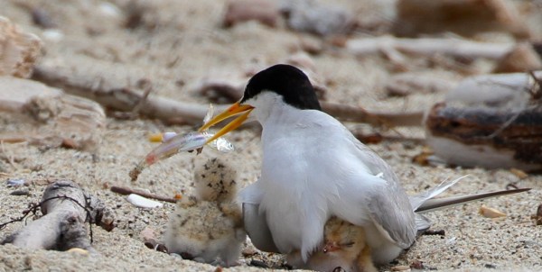
(Joyce Waterman, July 23 2017)
Not all rainwater gets into the creek
Not all rainfall within the watershed makes it into the creek. Some soaks into the soil, some is taken up by plants, some is diverted into household gutters and rainfall retention systems. I don’t have the information to estimate that loss. My understanding is that most of the water that falls on hard surfaces is eventually funneled into the creek. The harder the rainfall, the greater the percentage of water that lacks sufficient time to soak into the ground and therefore makes it into the creek.
The effect on Malibu Creek
My estimate of ½-inch of rain being sufficient to blow through the beach is – from the chart above – the equivalent of 2,912 acre-feet of water, almost 1 billion gallons of water weighing almost 4 million tons, the equivalent of almost 50 thousand Malibu Swimming Pools (MSPs).
This water carries a great deal of sediment down the creek and into the lagoon, and when the lagoon is open to the ocean, much of it flows into the ocean. Some is deposited and some will be carried away by the longshore current which usually flows – often strongly – to the east. The local surfers believe, probably correctly, that the three offshore reefs or “points” that create the surfing waves they love are replenished by this sediment. For this reason, they are highly interested is seeing this sediment flow continue, and manually reopened the breach when it periodically closes, whatever current law prohibits or permits.
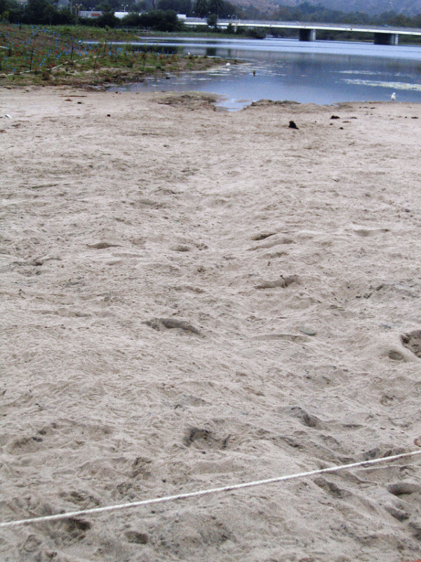
Over the past three decades they have often dug a channel through the beach, as far to the west as practical, for the lagoon and creek water to flow out and the reefs to be replenished. Until the 1990’s local authorities would mechanically create a breach to allow sediment to flow out, along with whatever pollution and bacteria accumulated in the lagoon. Bacterial counts were often very high. In the mid-nineties these semi-official breaches ceased due to changes in laws and the classifying of the Tidewater Goby as endangered. Since then, unofficially and under cover of darkness, the local surfers have done this work, as necessary, as they saw fit. Word has it that after the breach is completed, surfers wait at least a few days before re-entering the ocean, giving any pollution, detritus and bacteria that had flowed from lagoon to sea time to dissipate. [All references to these trenching activities is hearsay, based on conversations I’ve had over the decades with surfers, none of whom I personally knew, as they walk to and from the beach. The trench-breaches, however, do not dig themselves, except after rainstorms, as noted.]
If the amount of sediment currently carried by Malibu Creek into the lagoon and ocean has ever been calculated, I can’t find it. However, it can be estimated by calculating the volume of sediment currently deposited behind Rindge Dam, completed in 1926, divided by the number of years it took to fill up.
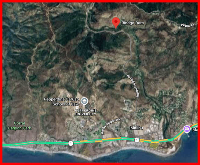
Reportedly, the reservoir behind the dam had filled up with 780,000 cubic yards of sediment by 1947 (SoCal Sierra Club report). [800,000 cu. yds. per California Trout.] With 21 years of sediment buildup, that averages to over 37,000 cubic yards per year. That’s a minimum, as any creek water getting past the dam will be carrying sediment.
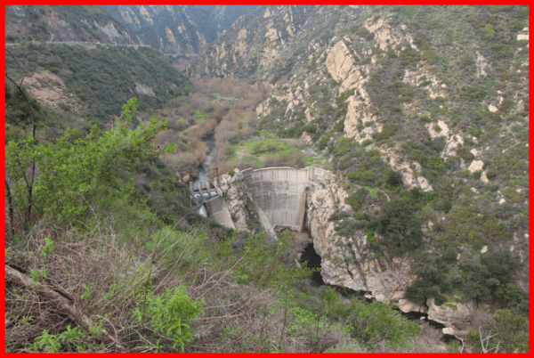
Just for the sake of interest, and assuming that most of the sediment is sand (eroded sandstone), a single cubic yard of sand weighs 2600-2700 lbs., or 4/3rds of a ton. That works out to 49,000 tons of sediment stored behind the dam per year, or over a million tons of sediment resting behind the dam since 1947. I’m sure that many of the surfers, homeowners and beachgoers wish that some or all of that sand had made it down the creek and out onto the beaches and surfing reefs. Not to mention the fish urged by instinct to swim upstream, only to be obstructed in their quest.
About 25 years ago at one of the Malibu Creek Watershed Advisory Council and Steering Committee meetings, when the topic of Rindge Dam removal came up, I – getting tired of nothing more than talk and “we need another study” – suggested the following:
Why don’t we cut a wedge out of the top center of this 100-ft dam, say 10 feet wide and 1-5 ft deep. When the rains come they’ll wash a lot of sediment over the dam and on down the creek in the storm flow. Take a look at the situation every three months or every year, and deepen and/or widen the wedge cut as necessary to let the sediment continue to wash away. If we can cut it down 5 feet per year for 20 years, the problem is gone. That way you won’t have to make thousands of trips to truck away the silt, and it’ll replenish Malibu Beach and the surfing reefs and onward eastward around the bay.
It seemed they’d never considered that path, and didn’t want to consider it then either. Cranes and trucks was the way to go. Now, 26 years later, with not a single spoonful of silt or pebble of dam yet removed, cranes and trucks still seems to be the only plan considered. And it will take 2,000-3,000 truckloads to haul away all that silt. I’ve previously written about this here.
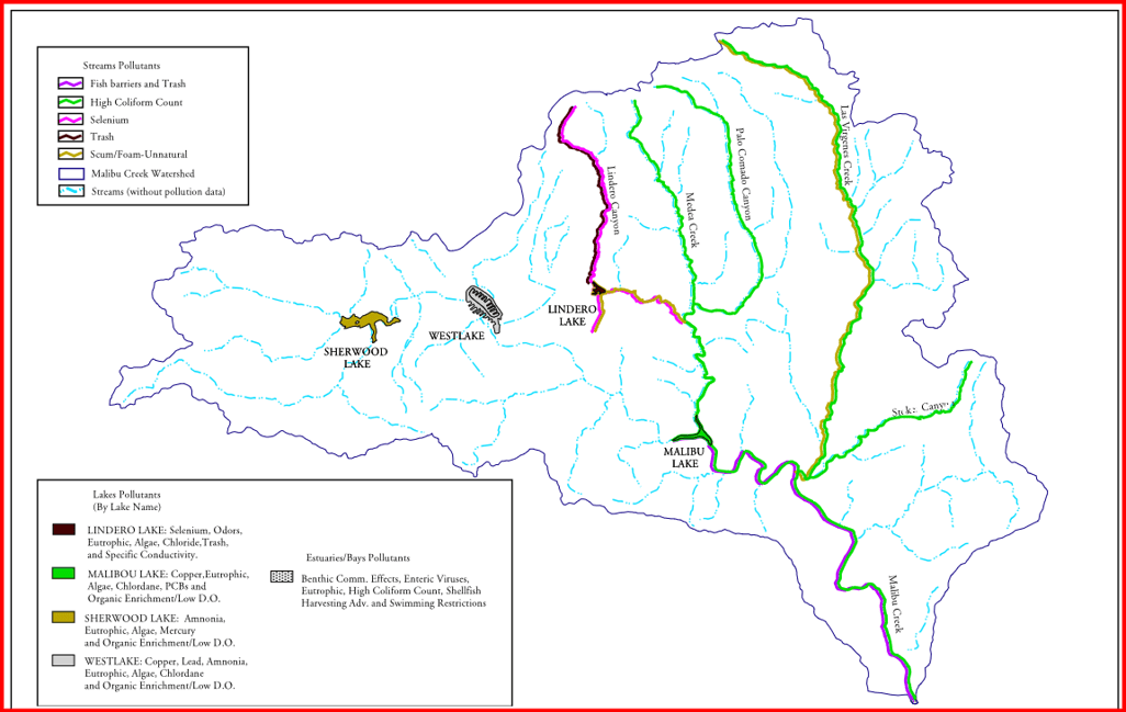
Map of Malibu watershed from the Watershed Management Area Plan report, page 33.
Water I: Rainfall, watershed, beach erosion, Rindge Dam
Water II: Storm of October 21-23, 2026, lagoon and beach effects
Water III: The warming ocean
Appendix: Table of Acreages, Derivative Units of Water
Map from the Watershed Management Area Plan report, page 16. There are other interesting maps in this document.
Below is Table 1, page 26 from Watershed Management Area Plan for the Malibu Creek Watershed, mentioned in paragraph 2 above. Acreage of watershed land use classes listed totals to 69,887.2 acres.
Units used in calculations
Malibu Creek watershed area: ≈109 sq. mi.
Acres per square mile: 640
Watershed area: 69,887 acres
Square feet: 3,044,277,720 sq.ft.
Gallons per watershed-foot: 22,772,748,837 gallons
Water weight per watershed foot: 189,924,725,301lbs
Water weight per watershed foot: 94,962,363 tons
Water weight per watershed foot: 9.5 megatons
One acre-foot of water (acre of water one foot deep)
Square feet per acre: 43,560 sq.ft.
Cubic feet per acre-foot: 43,560 sq.ft.
Gallons per cubic foot: 7.4805 gallons
Gallons per acre-foot: : 325,851 gallons
Weight of water per gallon: 8.34 lbs
Weight of water per cubic foot: 62.4 lbs
Weight of water per acre-foot: 363,290 lbs
Weight of water per acre-foot: 181.6 tons
Malibu Swimming Pool units:
MSP size: 16′ x 32′ x 5.222′, or 2,673.66 cu.ft.
MSP gallons: 20,000
MSP water weight: 166,800 lbs or 83.4 tons
MSP’s per watershed-foot: 1,138,637
Discover more from SANTA MONICA BAY AUDUBON SOCIETY BLOG
Subscribe to get the latest posts sent to your email.