Free email delivery
Please sign up for email delivery in the subscription area to the right.
No salesman will call, at least not from us. Maybe from someone else.
Trimming your trees in SoCal
[Posted by Chuck Almdale]
Our friendly neighboring Audubon Chapter, Los Angeles Audubon Society, has a handy booklet on tree-trimming do’s and don’t when birds are, or may be, using them for nesting or roosting. You can print your own 6-page copy for free by following the link below.
On our SMBAS blog site in the right-side column of web-links, look under “Plant Links” for “Tree-trimming in SoCal.”
Or go to https://www.laaudubon.org/resources “Urban Nature Resources,” scroll down to Bird-Friendly Tree Trimming, and select either English or Spanish.
Los Angeles County has more than 350 species of birds that live, nest, or pass through during annual migrations, and there are more than 120 species that live here year-round. Therefore, maintaining adequate green space for birds is critical. Birds are beautiful, economically important, and they are a bellwether of the health of our environment.

[Posted by Chuck Almdale, suggested by Grace Murayama]
Grace writes in:
In case anyone missed the Los Angeles Times article, in print 5/31/21, “A new state quarantine, but it’s not for that“, re: warning not to eat locally harvested shellfish ( mussels, clams, oysters, scallops), marine biotoxins, algae, domoic acid, paralytic shellfish poisoning, etc.
From the Los Angeles Times:
Officials with the Orange County Health Care Agency, the body tasked with oversight of public health programs during the COVID-19 pandemic, on Thursday announced a different kind of quarantine would be imposed through October: on mussels for human consumption.
Through Oct. 31, residents across California are being warned not to eat mussels and other potentially toxic shellfish collected by sports harvesters from coastal waters.
The reason? Harmful marine biotoxins produced by some species of microscopic algae can be absorbed by the digestive systems of mussels, clams, oysters and scallops. The consumption of affected mollusks puts humans at risk of paralytic shellfish poisoning.
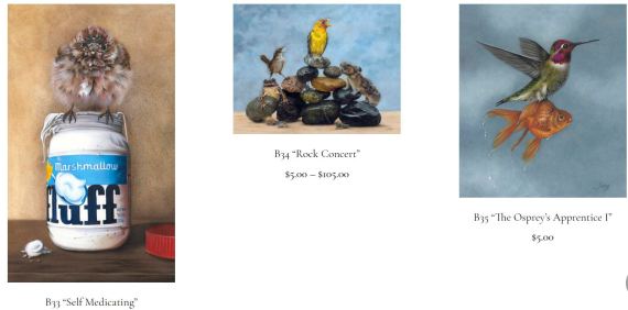
Break Glass in Case of Emergency | Eileen Sorg
[Posted by Chuck Almdale]

“Break Glass in case of Emergency.” Painting by Eileen Sorg
Where there’s a will, there’s a way. For me, this image embodies that sentiment and there is no doubt that this group of hummingbirds will get to their reward one way or another. — Eileen Sorg
My sister-in-law Diana received this card from her daughter; she then emailed a photo of it to us. Diana’s photo has a bit more clarity than the image above, which I found on the web. I mention this because it means Eileen Sorg’s artwork has excellent, clear detail, better than what I am able to reproduce here. I believe the above painting is done in colored pencil, as is much of her work.
This is not an advertisement. Neither SMBAS nor myself nor anyone I know is getting any commissions from this. I like Sorg’s artwork for it’s combination of attention to detail, humor, fantasy, composition, skill, and her inclusion of real, identifiable birds. I think many others will like it as well. There’s quite a selection on her website https://twodogstudio.com/. Her work is sold as either cards or large prints.
Here’s a few more:
Pacific Loon in breeding plumage at Malibu Lagoon
[Posted by Chuck Almdale, photos by Chris Tosdevin]
Chris Tosdevin found a Pacific Loon in full breeding (alternate) plumage sitting on the edge of Malibu Lagoon this morning (Sunday, 5-23-21). Loons have generally left by this time of year, and he wondered what May records I have for it.
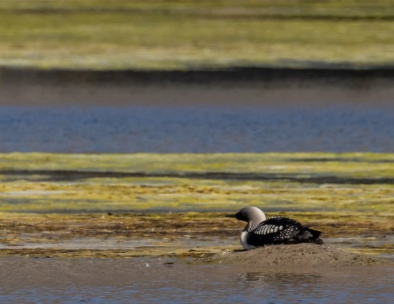
I can’t recall seeing Pacific Loon in breeding plumage in SoCal before. I do have records for them in May, so they were probably at least well on their way into breeding plumage, but they offshore—distant, small, taking long dives for fish or disappearing frequently behind incoming waves. Hard to see, in other words. Certainly not conveniently sitting at the edge of the lagoon, looking out over the algae.

My ‘loon history’ is below. Only eight sightings in May. That’s out of 287 census dates since October 1979, including 24 dates in May.

The eight Pacific Loons previously sighted in May consisted of:
1- 5/24/15, 1 – 5/25/14, 5 – 5/23/10, 1 – 5/24/09.
This is a really stunning bird. I wish I’d seen it.

Loons have webbed feet and are wonderful swimmers, diving deeply. Their legs are far back on their bodies, relative to ducks. This makes them poorly balanced on land, and it is very difficult for them to walk. Their nests are always placed close to water. When they’re not nesting, they’re in the water, including when they sleep. If you see a loon on land away from its nesting grounds, and you rarely will, it may be sick or wounded.
The Pacific Loon’s scientific name is Gavia pacifica; Gavia began as Latin for “gull,” which was fine many centuries ago when just about anything on the water and not a duck might be called a gull and no one cared. The choice of Gavia for the loons was made in 1789 by Johann Reinhold Forster (1729-1798), who sailed with Captain Cook in 1772 in his circumnavigation of the world.
The name “Loon” is a corruption of Shetlandic loom, from Icelandic lomr, and from Danish or Swedish lom. They all mean “lame,” in reference to their awkward manner of walking on land. The British call them “Divers.”
The phrase “crazy as a loon” may refer to the similarity of its call to insane laughter, which you may sometimes hear issuing from the “loony bin.”
[Posted by Chuck Almdale]
Rising sea levels are in our present and in our future. Due to the little-known effects of the moon’s orbital tilt and the precession of the orbital nodes, we are in the middle of a 9.3-year dampening of the sea level rise, and currently see little-to-no rise. But in 2026-2035, we enter a 9.3-year-long enhancement of sea level rate-of-rise and will see an approximately four-inch permanent rise.
To recapitulate part I:
- The moon’s gravitational pull creates a bulge in the ocean. Inertia in the water creates another bulge on the opposite side of the planet.
- The rotation of the earth causes these bulges to move around the globe once per day.
- The additional gravitational pull from the sun at new moon and full moon causes the monthly cycle of highest highs and lowest lows in the daily tide.
- The elliptical orbit of the moon around the earth causes supermoon at perigee and micromoon at apogee.
- The elliptical orbit of the earth around the sun causes annual highest and lowest tides centered on the January 4 perihelion, and annual most-moderate tides at aphelion six months later.
The moon’s tilted orbit and the nodes
The moon’s orbit is not only an ellipse with the earth at one focus, it is tilted at 5.14 degrees to the ecliptic (the plane of earth’s orbit around the sun). A total solar eclipse can occur when the moon is between sun and earth, but usually doesn’t because the moon is above or below the plane of the ecliptic; we see it pass above or below the sun, and its shadow does not touch the earth. Thus, no eclipse.
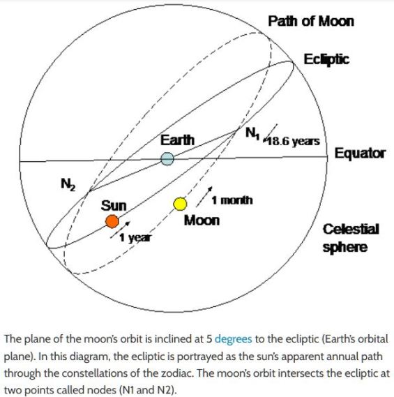
But there are two points where the the moon’s orbit passes through the plane of the earth’s orbit. These are called the moon’s north and south nodes. If you’re an astronomy professional or amateur or a professional astrologer, you know about the nodes; otherwise, probably not. Imagine a dinner plate lying on a table, with a larger hoop surrounding it. If both are lying flat on the table, they’re in the same plane, Tilt the hoop slightly (imagine the descending half passing downward through the table) and now their planes intersect at only two points, which are the nodes.
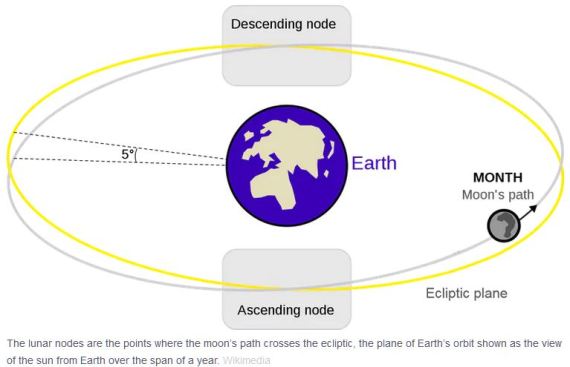
In the above figure, the yellow circle is the plane of the ecliptic, the path the sun appears to move through as the earth circles the sun. The blue circle is the moon’s orbit. At the ascending (north) node, the moon’s path moves above (north of) the ecliptic; at the descending (south) node the moon’s path moves below the ecliptic. The angle between these two planes—ecliptic and moon’s orbit—is always 5.14 degrees.
Solar and lunar eclipses occur only where the moon’s orbit falls exactly between the earth and sun, and the two nodes are the only places where that can occur. Thus total eclipses of the sun or moon can occur only when the moon is passing through its north node or south note at the same moment that the earth-moon-sun are in a direct line, or syzygy. Because of this, the technical term for supermoon is perigee-syzygy of the Earth-Moon-Sun system.
The two nodes are always opposite one another but are not fixed relative to the constellations. The nodal points slowly circle the earth, moving backwards through the zodiac (the twelve constellations lying on the plane of the ecliptic) over an 18.6 year period. For example, a node moves backwards through Virgo (astrological sign 6) for 1.5 years, then enter Leo (sign 5) and move slowly backwards through that constellation for 1.5 years, and so on through the twelve constellations of the zodiac. As the timing of the nodal cycle intersects with eclipses, perigees and perihelions, all of which affect the tides, the movement of the nodes also affects the height of the tides over an 18.6 year period.
The Wobbling Moon
It does this because the moon’s orbit wobbles, in the manner of a dinner plate or large coin—slowing down after being spun—wobbling just before it completely settles down. Just as the wobbling plate’s point of contact with the table moves around in a circle in a fraction of a second, so do the moon’s orbital nodes move, or precess, backward through the zodiacal constellations on the ecliptic, taking 18.6 years to make a complete circle.
In the YouTube video below, start at time 1:30 to best see the wobbling dinner plates. As the spinning slows down and the entire plate edge approaches the table surface, it visually replicates quite well the moon’s orbital wobble. Or watch the entire manic 3.25-minute act of Erich Brenn, inspiration to millions back in the 1950’s, something to take people’s minds off the Cold War.
Scientists have long wondered why the moon’s orbital plane is not the same as the plane of the ecliptic. In 2015 two planetary scientists – Kaveh Pahlevan and Alessandro Morbidelli – published a paper describing computer simulations showing that the “effect of collisionless encounters [near-hits] between the Earth-moon system and large objects, similar to what we today call asteroids, leftover from the formation of the inner planets…. could have gravitationally jostled the moon into a tilted orbit.” Their results were published in the journal Nature. (From EarthSky)
The earth’s axial tilt relative to the plane of the ecliptic is currently 23.5° (another cyclic angle, varying from 22.1° to 24.5° over a 40,000-year period). When you add this to the 5.14° declination (tilt) of the moon’s orbit to the plane of the ecliptic, we find that the declination of the moon’s orbit relative to the plane of the earth’s equator varies from 28.725° to 18.134° north or south of the equator. This declination varies over the same 18.6-year cycle as does the precession of the moon’s nodes. It is this changing declination relative to the equator (not to the ecliptic) that causes the moon’s gravitational pull on oceanic waters to fluctuate over this 18.6-year period.
The nodal cycle and the rising ocean
We are currently in a period when the nodal cycle’s influence on tides is waning. (See chart below.) This part of the 18.6-year cycle began in 2017 and ends in 2027, at which point the cycle’s influence begins to rise, peaking in 2035.
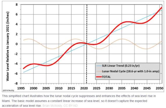
Projecting the sea level to rise 0.23 inches per year (a linear projection*), displayed as the straight blue line in the chart above, we see the effect of this rise interacting with the influence of the nodal cycle as the thick wavy red line. This line takes a sharp upturn around 2027, then plateaus in 2037. It never significantly drops after that. Each plateau is roughly 4 inches higher than the preceding plateau.
*[Most climate scientists expect the rate of sea level rise be non-linear, i.e. to speed up. But it’s easier to create the above chart using a linear increase.]
Each plateau begins 18.6 years after the start of the previous plateau, or 9.3 years after the end of the previous plateau. In 2037, expect the sea level to be approximately four inches higher than it is right now, then an additional four inch increase by 2056, four more inches by 2075 and again by 2095, at which point sea level will be 16 inches higher than today. And it keeps going. The moon’s 18.6-year orbital wobble is billions of years old. It’s not going away. As long as the sea level rises—fast or slow, linear or non-linear—we will see 9.3 years of plateauing or slight dropping alternating with 9.3 years of rapid rise.
These are projections, of course. Perhaps the projected linear trend of sea level rise will be 0.23 inches. Perhaps it will be more, perhaps less, or (more likely) non-linear. One thing for certain, it won’t be zero. It is rising and it will continue to rise for decades to come.

Malibu Beach king tide (Larry Loeher 1-13-21)
One reason civilizations collapse is degrading infrastructure, especially when combined with difficult climatic or geological events: little ice ages, droughts, deforestation, floods, sea level rise, rising temperatures, earthquakes, volcanoes, plagues, pandemics. (I’m sorry if this is starting to sound apocalyptic.) It is often more costly to repair structures or infrastructure that it was to construct them. Sometimes peoples just pick up and start over elsewhere.
When you combine four, eight, twelve, or sixteen inches of sea level rise with the effects of storms, including hurricanes, there’s going to be a lot of expensive destruction along our coasts. Businesses, highways, homes, subways, ports, parks, piers – the list goes on. We’d better be ready to write off a lot of structural and financial loss, both individually and as a society. I’m sure our insurance companies have contingency plans for dealing with the claims. Don’t be surprised if their plans involve exception clauses for flooding, or using bankruptcy to seek protection from claimants.
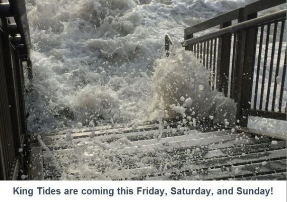
Alarming photo courtesy of the California Coastal Commission
For some great photos of the 5/26/21 supermoon lunar eclipse, taken in Australia, go here:
http://www.atscope.com.au/BRO/bardenridgeobs.html
If you didn’t already watch this great short film from Inside Science, only 2:42 long, watch it now:
The following blog posting was the inspiration and primary source of information on the node-tide relationship:
This supermoon has a twist – expect flooding, but a lunar cycle is masking effects of sea level rise. Brian McNoldy | TheConversation.com | 4-23-21
The following websites were additional sources of information:
Shape of Lunar Orbit
Joshua E. Barnes | IFA.Hawaii.edu | 3-11-03
Why not an eclipse at every full and new moon?
Astronomy Essentials | EarthSky.org | 5-17-21
What Is a Supermoon and When Is the Next One?
Vigdis Hocken & Aparna Kher | TimeAndDate.com
Orbit of the moon
Lunar Standstill
Wikipedia
Supermoon, Blood Moon, Blue Moon and Harvest Moon
Nasa Science SpacePlace
Lunar Eclipses and the Moon’s Orbit
Ernie Wright | NASA Science Visualization Studio | 4-10-14
Lunar apogee & perigee calculator
John Walker | fourmilab.ch | 5-5-97
Monthly Lunar Standstills: 2001 to 2100
Astropixels.com | 12-21-13


