Free email delivery
Please sign up for email delivery in the subscription area to the right.
No salesman will call, at least not from us. Maybe from someone else.
Pacific Loon in breeding plumage at Malibu Lagoon
[Posted by Chuck Almdale, photos by Chris Tosdevin]
Chris Tosdevin found a Pacific Loon in full breeding (alternate) plumage sitting on the edge of Malibu Lagoon this morning (Sunday, 5-23-21). Loons have generally left by this time of year, and he wondered what May records I have for it.
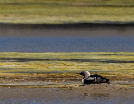
I can’t recall seeing Pacific Loon in breeding plumage in SoCal before. I do have records for them in May, so they were probably at least well on their way into breeding plumage, but they offshore—distant, small, taking long dives for fish or disappearing frequently behind incoming waves. Hard to see, in other words. Certainly not conveniently sitting at the edge of the lagoon, looking out over the algae.

My ‘loon history’ is below. Only eight sightings in May. That’s out of 287 census dates since October 1979, including 24 dates in May.

The eight Pacific Loons previously sighted in May consisted of:
1- 5/24/15, 1 – 5/25/14, 5 – 5/23/10, 1 – 5/24/09.
This is a really stunning bird. I wish I’d seen it.

Loons have webbed feet and are wonderful swimmers, diving deeply. Their legs are far back on their bodies, relative to ducks. This makes them poorly balanced on land, and it is very difficult for them to walk. Their nests are always placed close to water. When they’re not nesting, they’re in the water, including when they sleep. If you see a loon on land away from its nesting grounds, and you rarely will, it may be sick or wounded.
The Pacific Loon’s scientific name is Gavia pacifica; Gavia began as Latin for “gull,” which was fine many centuries ago when just about anything on the water and not a duck might be called a gull and no one cared. The choice of Gavia for the loons was made in 1789 by Johann Reinhold Forster (1729-1798), who sailed with Captain Cook in 1772 in his circumnavigation of the world.
The name “Loon” is a corruption of Shetlandic loom, from Icelandic lomr, and from Danish or Swedish lom. They all mean “lame,” in reference to their awkward manner of walking on land. The British call them “Divers.”
The phrase “crazy as a loon” may refer to the similarity of its call to insane laughter, which you may sometimes hear issuing from the “loony bin.”
[Posted by Chuck Almdale]
Rising sea levels are in our present and in our future. Due to the little-known effects of the moon’s orbital tilt and the precession of the orbital nodes, we are in the middle of a 9.3-year dampening of the sea level rise, and currently see little-to-no rise. But in 2026-2035, we enter a 9.3-year-long enhancement of sea level rate-of-rise and will see an approximately four-inch permanent rise.
To recapitulate part I:
- The moon’s gravitational pull creates a bulge in the ocean. Inertia in the water creates another bulge on the opposite side of the planet.
- The rotation of the earth causes these bulges to move around the globe once per day.
- The additional gravitational pull from the sun at new moon and full moon causes the monthly cycle of highest highs and lowest lows in the daily tide.
- The elliptical orbit of the moon around the earth causes supermoon at perigee and micromoon at apogee.
- The elliptical orbit of the earth around the sun causes annual highest and lowest tides centered on the January 4 perihelion, and annual most-moderate tides at aphelion six months later.
The moon’s tilted orbit and the nodes
The moon’s orbit is not only an ellipse with the earth at one focus, it is tilted at 5.14 degrees to the ecliptic (the plane of earth’s orbit around the sun). A total solar eclipse can occur when the moon is between sun and earth, but usually doesn’t because the moon is above or below the plane of the ecliptic; we see it pass above or below the sun, and its shadow does not touch the earth. Thus, no eclipse.
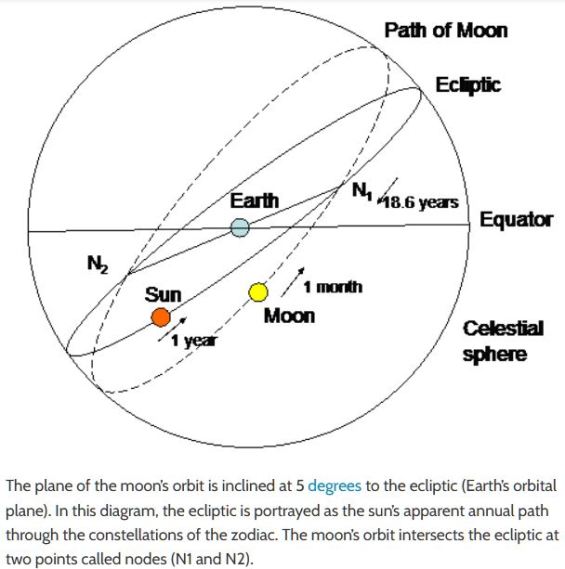
But there are two points where the the moon’s orbit passes through the plane of the earth’s orbit. These are called the moon’s north and south nodes. If you’re an astronomy professional or amateur or a professional astrologer, you know about the nodes; otherwise, probably not. Imagine a dinner plate lying on a table, with a larger hoop surrounding it. If both are lying flat on the table, they’re in the same plane, Tilt the hoop slightly (imagine the descending half passing downward through the table) and now their planes intersect at only two points, which are the nodes.
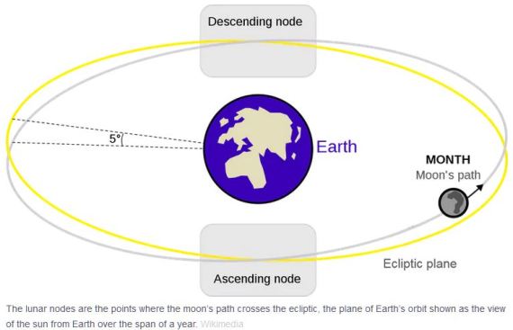
In the above figure, the yellow circle is the plane of the ecliptic, the path the sun appears to move through as the earth circles the sun. The blue circle is the moon’s orbit. At the ascending (north) node, the moon’s path moves above (north of) the ecliptic; at the descending (south) node the moon’s path moves below the ecliptic. The angle between these two planes—ecliptic and moon’s orbit—is always 5.14 degrees.
Solar and lunar eclipses occur only where the moon’s orbit falls exactly between the earth and sun, and the two nodes are the only places where that can occur. Thus total eclipses of the sun or moon can occur only when the moon is passing through its north node or south note at the same moment that the earth-moon-sun are in a direct line, or syzygy. Because of this, the technical term for supermoon is perigee-syzygy of the Earth-Moon-Sun system.
The two nodes are always opposite one another but are not fixed relative to the constellations. The nodal points slowly circle the earth, moving backwards through the zodiac (the twelve constellations lying on the plane of the ecliptic) over an 18.6 year period. For example, a node moves backwards through Virgo (astrological sign 6) for 1.5 years, then enter Leo (sign 5) and move slowly backwards through that constellation for 1.5 years, and so on through the twelve constellations of the zodiac. As the timing of the nodal cycle intersects with eclipses, perigees and perihelions, all of which affect the tides, the movement of the nodes also affects the height of the tides over an 18.6 year period.
The Wobbling Moon
It does this because the moon’s orbit wobbles, in the manner of a dinner plate or large coin—slowing down after being spun—wobbling just before it completely settles down. Just as the wobbling plate’s point of contact with the table moves around in a circle in a fraction of a second, so do the moon’s orbital nodes move, or precess, backward through the zodiacal constellations on the ecliptic, taking 18.6 years to make a complete circle.
In the YouTube video below, start at time 1:30 to best see the wobbling dinner plates. As the spinning slows down and the entire plate edge approaches the table surface, it visually replicates quite well the moon’s orbital wobble. Or watch the entire manic 3.25-minute act of Erich Brenn, inspiration to millions back in the 1950’s, something to take people’s minds off the Cold War.
Scientists have long wondered why the moon’s orbital plane is not the same as the plane of the ecliptic. In 2015 two planetary scientists – Kaveh Pahlevan and Alessandro Morbidelli – published a paper describing computer simulations showing that the “effect of collisionless encounters [near-hits] between the Earth-moon system and large objects, similar to what we today call asteroids, leftover from the formation of the inner planets…. could have gravitationally jostled the moon into a tilted orbit.” Their results were published in the journal Nature. (From EarthSky)
The earth’s axial tilt relative to the plane of the ecliptic is currently 23.5° (another cyclic angle, varying from 22.1° to 24.5° over a 40,000-year period). When you add this to the 5.14° declination (tilt) of the moon’s orbit to the plane of the ecliptic, we find that the declination of the moon’s orbit relative to the plane of the earth’s equator varies from 28.725° to 18.134° north or south of the equator. This declination varies over the same 18.6-year cycle as does the precession of the moon’s nodes. It is this changing declination relative to the equator (not to the ecliptic) that causes the moon’s gravitational pull on oceanic waters to fluctuate over this 18.6-year period.
The nodal cycle and the rising ocean
We are currently in a period when the nodal cycle’s influence on tides is waning. (See chart below.) This part of the 18.6-year cycle began in 2017 and ends in 2027, at which point the cycle’s influence begins to rise, peaking in 2035.
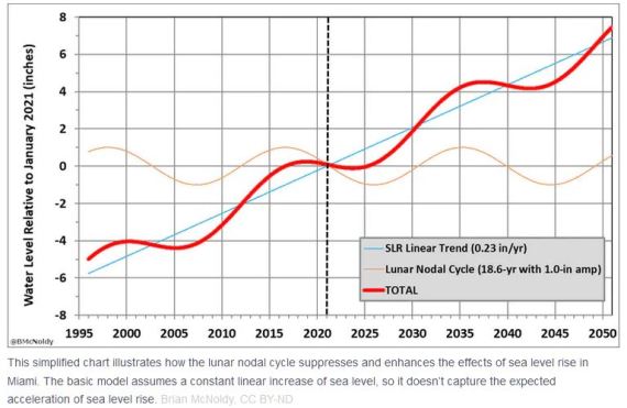
Projecting the sea level to rise 0.23 inches per year (a linear projection*), displayed as the straight blue line in the chart above, we see the effect of this rise interacting with the influence of the nodal cycle as the thick wavy red line. This line takes a sharp upturn around 2027, then plateaus in 2037. It never significantly drops after that. Each plateau is roughly 4 inches higher than the preceding plateau.
*[Most climate scientists expect the rate of sea level rise be non-linear, i.e. to speed up. But it’s easier to create the above chart using a linear increase.]
Each plateau begins 18.6 years after the start of the previous plateau, or 9.3 years after the end of the previous plateau. In 2037, expect the sea level to be approximately four inches higher than it is right now, then an additional four inch increase by 2056, four more inches by 2075 and again by 2095, at which point sea level will be 16 inches higher than today. And it keeps going. The moon’s 18.6-year orbital wobble is billions of years old. It’s not going away. As long as the sea level rises—fast or slow, linear or non-linear—we will see 9.3 years of plateauing or slight dropping alternating with 9.3 years of rapid rise.
These are projections, of course. Perhaps the projected linear trend of sea level rise will be 0.23 inches. Perhaps it will be more, perhaps less, or (more likely) non-linear. One thing for certain, it won’t be zero. It is rising and it will continue to rise for decades to come.

Malibu Beach king tide (Larry Loeher 1-13-21)
One reason civilizations collapse is degrading infrastructure, especially when combined with difficult climatic or geological events: little ice ages, droughts, deforestation, floods, sea level rise, rising temperatures, earthquakes, volcanoes, plagues, pandemics. (I’m sorry if this is starting to sound apocalyptic.) It is often more costly to repair structures or infrastructure that it was to construct them. Sometimes peoples just pick up and start over elsewhere.
When you combine four, eight, twelve, or sixteen inches of sea level rise with the effects of storms, including hurricanes, there’s going to be a lot of expensive destruction along our coasts. Businesses, highways, homes, subways, ports, parks, piers – the list goes on. We’d better be ready to write off a lot of structural and financial loss, both individually and as a society. I’m sure our insurance companies have contingency plans for dealing with the claims. Don’t be surprised if their plans involve exception clauses for flooding, or using bankruptcy to seek protection from claimants.
Alarming photo courtesy of the California Coastal Commission
For some great photos of the 5/26/21 supermoon lunar eclipse, taken in Australia, go here:
http://www.atscope.com.au/BRO/bardenridgeobs.html
If you didn’t already watch this great short film from Inside Science, only 2:42 long, watch it now:
The following blog posting was the inspiration and primary source of information on the node-tide relationship:
This supermoon has a twist – expect flooding, but a lunar cycle is masking effects of sea level rise. Brian McNoldy | TheConversation.com | 4-23-21
The following websites were additional sources of information:
Shape of Lunar Orbit
Joshua E. Barnes | IFA.Hawaii.edu | 3-11-03
Why not an eclipse at every full and new moon?
Astronomy Essentials | EarthSky.org | 5-17-21
What Is a Supermoon and When Is the Next One?
Vigdis Hocken & Aparna Kher | TimeAndDate.com
Orbit of the moon
Lunar Standstill
Wikipedia
Supermoon, Blood Moon, Blue Moon and Harvest Moon
Nasa Science SpacePlace
Lunar Eclipses and the Moon’s Orbit
Ernie Wright | NASA Science Visualization Studio | 4-10-14
Lunar apogee & perigee calculator
John Walker | fourmilab.ch | 5-5-97
Monthly Lunar Standstills: 2001 to 2100
Astropixels.com | 12-21-13
[Posted by Chuck Almdale]
Rising sea levels are in our present and in our future. Due to the little-known effects of the moon’s orbital tilt and the precession of the orbital nodes, we are in the middle of a 9.3-year dampening of the sea level rise, and currently see little-to-no rise. But in 2026-2035, we enter a 9.3-year-long enhancement of sea level rate-of-rise and will see an approximately four-inch permanent rise.
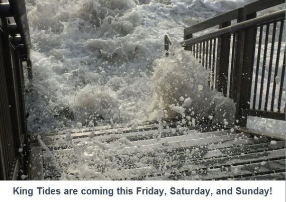
The lunar gravitational pull affects our oceanic tides and is the primary cause of our daily tides. The solar gravitation pull is a secondary factor, but when moon and sun are in alignment (as seen from earth) at new and full moons, they work together to create the cycle of highest high and lowest low monthly tides, the annual northern winter “king” tides, and other even longer tidal cycles.
There are other, local influences: latitude, shape of the offshore ocean floor, the magnifying effect of narrowing bays. Most locations have two high and two low tides every day, as we do in Southern California; other locations—such as the Gulf of Mexico—have one high and one low tide per day. The discussion that follows is of a general nature, not absolutely true for all locations at all times of the day or year.
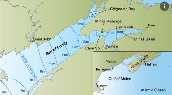
The Bay of Fundy tidal funneling effect—the farthest, narrowest points have the greatest tidal height fluctuation.
Supermoons
There’s a “super full moon” and total lunar eclipse scheduled for May 26, 2021. Flooding may occur at some low-lying coastal areas. This will be due to predictable high tides, not to unpredictable and unlikely tsunamis. The total lunar eclipse starts at 4:11 AM PDT (11:11 UTC) and lasts 14.5 minutes. There will be another super full moon (but no eclipse) on 6-24-21.

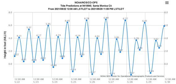
The chart below shows predicted tides for Santa Monica Pier for May 22-29, 2021. Highest tide is +6.89 ft. at 9:44 PM on 5-26-21. Lowest tide is -1.74 ft. at 5:00 AM on 5-27-21. These are very high and very low tides for this location.
Super full moons (and super new moons) occur when the moon is at perigee (closest approach to the earth). The moon’s orbit is an ellipse, not a circle. The average earth center-moon center distance is 238,000 miles, but can be as close as 223,694 miles at perigee during supermoon or as far as 251,655 miles at apogee during micromoon. A super moon appears 14% larger and 30% brighter than a micromoon. (Super- and micromoon are not official astronomical terms, so there’s no hard definition concerning distances.) Supermoons, being closer to the earth, have an increased gravitational pull and tidal fluctations are greater, with higher highs and lower lows. The higher high tide can cause flooding. The lower low tide makes for nice tide pools.

Ellipse: Draw an ellipse by stretching a string from focus 1 to (x,y) to focus 2. Hold down the two string ends at the focii. Place a pencil tip at (x,y) and—keeping the string taut—make a line around the two focii. The result is the above ellipse. The farther apart the focii, the more elongated the ellipse. Kepler’s first two laws of planetary motion, formulated around 1610, state that 1) the orbit of a planet is an ellipse with the sun at one of the two focii, and 2) a line segment connecting the orbiting planet to the sun sweeps out equal areas during equal periods of time. Thus the moon in its elliptical orbit moves more quickly when near the earth.
The Tides
Daily high tides are caused by the moon’s gravitational pull on the ocean water closest to it, causing a bulge in the water. The earth rotates once per day and this bulge moves around the earth once per day. The water’s inertia causes a lesser bulge on the opposite side of the planet. Low tides fall between the two bulges. Thus, for most places, there are two high and two low tides per 24-hour period, with the higher of the two high tides on the side facing the moon. On average, it’s 24 hours and 50 minutes from one daily highest tide to the next. If high tide occurs at noon one day, then (roughly) seven days later it will be low tide at noon. The moon’s “monthly” cycle from new moon to new moon is 29.53 days long.
Earth’s orbit is an ellipse: the average earth center-sun center distance is 92,955,807 miles, but at perihelion (closest point) it can be 1.7% shorter, at aphelion it can be 1.6% longer. The year’s highest tides occur during our northern winter when the earth is at or close to perihelion, around January 4. The earth approaches and leaves perihelion slowly so—depending on the other factors already mentioned—the actual annual highest tide can occur from November to March.
Eclipses

Solar eclipses occur when the moon passes between the sun and earth and the moon’s shadow falls on the earth’s surface. The total eclipse shadow is small—at most 166 miles in diameter—and a total solar eclipse is at most 7.5 minutes long. Lunar eclipses often occur 14 days before or after a solar eclipse when the earth is between sun and moon and the moon passes through the earth’s shadow. A lunar eclipse can be several hours long. This is sometimes called “blood on the moon” as the darkened moon often has a reddish hue, due to the scattering of sunlight passing through the earth’s atmosphere on it’s way to the moon.
So far we have the following:
- The moon’s gravitational pull creates a bulge in the ocean. Inertia in the water creates another bulge on the opposite side of the planet.
- The rotation of the earth causes these bulges to move around the globe once per day.
- The additional gravitational pull from the sun at new moon and full moon causes the monthly cycle of highest highs and lowest lows in the daily tide.
- The elliptical orbit of the moon around the earth causes supermoon at perigee and micromoon at apogee.
- The elliptical orbit of the earth around the sun causes annual highest and lowest tides centered on the January 4 perihelion, and annual most-moderate tides at aphelion six months later.
If these few orbital factors were all there were to the moon’s orbit, we’d have total lunar and solar eclipses every month. We don’t, as you’ve likely noticed. So there’s more.
Here’s a great short film from Inside Science, only 2:42 long:
Coming up in Part II
The moon’s tilted orbit and the nodes
The wobbling moon
The nodal cycle and the rising ocean
Sources and links
Heermann’s Gulls at Malibu Lagoon, 16 May 2021
[Posted by Chuck Almdale]
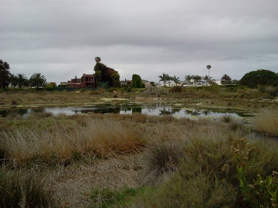
Lagoon & algae, Heermann’s Gulls, cormorants & pelicans, Surfrider Beach & the hills above Malibu (Ray Juncosa, 5-16-21)
The lagoon outlet is closed and the lagoon water level is high—7.0 ft above sea level on the tidal sidewalk. Recent warm weather (over 90° across the southland) warmed the water and algae now covers much of the surface. Algae usually is not this abundant until well into summer.

Yes, that’s water, all the way up to 7 feet above sea level (Lillian Johnson 5-15-21)
Weather was cloudy and cool with temperatures in the 59°-68° range in the morning. Tide was rising from the +1.57 ft. low at 7:36am. Very little wind and an ocean swell coming from somewhere far, far away brought really nicely shaped surf. A great many surfers dotted the waves all morning long.

A cloud-shrouded lagoon (L. Johnson 5-16-21)
Except for Mallard, Gadwall and Canada Goose, many of whom remain to nest, the ducks have all left. Only six coots and a single Pied-billed Grebe kept them company, so the lagoon surface was nearly empty.
The reed beds are still quite flattened from the storm over a month ago. One Green Heron found it a convenient spot to rest. These birds are regular visitors, but for some reason we’ve consistently missed them since November 2019.

Green Herons are olive-green on their back (R. Juncosa 5-16-21)
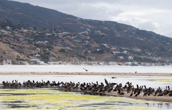
Brown Pelicans, Double-crested Cormorants, Elegant Terns, and Heermann’s Gulls were in relatively large numbers, most of them crowded onto one of the low and narrow sand islands near the lagoon’s southern edge.
We had 280 Heermann’s Gulls, all but two were sub-adult. Lu Plauzoles counted 36 juveniles. This struck all of us as an extraordinary number of Heermann’s, especially for May, when most of them are still down in Baja, finishing up their breeding season. So I did a little research and found:
Heermann’s Gulls at Malibu Lagoon
- Average May count for period 2011-2020: 11.2 birds.
- Years 2011-2020 with none present in May: 2011, 2017
- Previous high count in May: 61 on 5-27-07
- Sightings >100 birds: 9 out of 263 times they were present: 350 on 4-26-15, 280 5-16-21, 155 3-23-14, 142 1-23-05, 139 11-6-82, 127 1-28-07, 125 7-25-10, 120 10-23-05, 112 11-2-80.
So 280 birds on 5-16-21 was our highest May count by far, and the second highest count of all time. The most obvious assumption is that they finished nesting early and dispersed from Isla Rasa, where about 95% of them nest, along with most of the world’s Elegant Terns.

Brown Pelicans and (mostly) Elegant Terns. (R. Juncosa 5-16-21)
There were also 235 Brown Pelicans, another high number. Our all-time high for them is 1490 birds on 4-26-15, with an additional scattering of sightings in the mid-to-high hundreds. 107 Elegant Terns, 13 Caspian Terns and only 46 other gulls rounded out the gull/tern group.

Elegant Terns spooked easily, frequently taking flight for no apparent reason (R. Juncosa 5-16-21)
Shorebirds were almost entirely absent: 31 total sandpipers and plovers including 19 Marbled Godwit. Unusual among them was a lone male Red-necked Phalarope. This is one of the few North American species in which the female is more brightly plumaged than the male. Such sexual dimorphism reversal generally (if not always) signals polyandry, and all three of our phalarope species are indeed polyandrous, with the male performing most of the nesting duties including watching over the young.

Male Red-necked Phalarope paddling through the algae. The female is even more colorful. (R. Juncosa 5-16-21)
The ducks have already started breeding. Watching from the newly rebuilt observation deck atop the Adamson boathouse, we saw below us a pair of Mallards leading 4 downy ducklings from the brush into the small pool below. The puffball-ducklings were so buoyant they could hardly swim. Whatever they were pecking at on the water surface was too small to be seen by us. Perhaps they weren’t pecking at anything, but just imitating their parents feeding behavior. That’s how we all learn, isn’t it?
While walking back from Adamson House across the PCH bridge we spotted two Red-shouldered Hawks, flying overhead, heading west, one in sub-adult plumage and missing at least one flight feather, the other a very brightly plumaged adult. The last time we spotted this species, which has long nested not far upstream, was back in November 2018.
The swallows kept us very busy, constantly shooting above, by and between us, some high, some low. Most were bright rusty-brown and shiny-blue Barn Swallows, but Cliff Swallows, three Rough-winged and two Violet-green were also in the mix. The Violet-greens (or Violent Greens as they’re sometimes called) nests in our local mountains and farther north, but we see them nearly every year at the lagoon during migration.

Male House Finch keeps a close eye on those berries to his right (R. Juncosa 5-16-21)
Last but not least was a bright and colorful pair of Yellow Warblers, the male’s breast covered with red streaks, working the beach-edge bushes near Malibu Colony’s west-end fence.
Birds new for the season: Great Blue Heron, Green Heron, Red-shouldered Hawk, Western Kingbird,, Violet-green Swallow, Cliff Swallow, Oak Titmouse, Yellow Warbler.
Many thanks to photographers: Lillian Johnson & Ray Juncosa
The next SMBAS scheduled field trips: Maybe in September. We’ll see.
The next SMBAS program: We may have a June Zoom meeting. Watch for announcements.
The SMBAS 10 a.m. Parent’s & Kids Birdwalk remains canceled until further notice due to the near-impossibility of maintained proper masked social distancing with parents and small children.

(C. Tosdevin 4-25-21)
Links: Unusual birds at Malibu Lagoon
9/23/02 Aerial photo of Malibu Lagoon
Prior checklists:
2020: Jan-July, July-Dec 2019: Jan-June, July-Dec
2018: Jan-June, July-Dec 2017: Jan-June, July-Dec
2016: Jan-June, July-Dec 2015: Jan-May, July-Dec
2014: Jan-July, July-Dec 2013: Jan-June, July-Dec
2012: Jan-June, July -Dec 2011: Jan-June, July-Dec
2010: Jan-June, July-Dec 2009: Jan-June, July-Dec.
The 10-year comparison summaries created during the Lagoon Reconfiguration Project period, despite numerous complaints, remain available on our Lagoon Project Bird Census Page. Very briefly summarized, the results unexpectedly indicate that avian species diversification and numbers improved slightly during the restoration period June’12-June’14.
[Chuck Almdale]
| Malibu Census 2020-21 | 12/22 | 1/22 | 2/22 | 3/22 | 4/25 | 5/22 |
| Temperature | 57-64 | 60-61 | 65-74 | 60-61 | 58-63 | 59-68 |
| Tide Lo/Hi Height | L+2.15 | L+0.86 | L-0.13 | L+0.86 | H+4.83 | L+1.57 |
| Tide Time | 1052 | 1223 | 1314 | 1223 | 0843 | 0736 |
| Snow Goose | 2 | |||||
| (Black) Brant | 1 | |||||
| Canada Goose | 8 | 8 | 6 | 8 | 6 | |
| Cinnamon Teal | 4 | 7 | ||||
| Northern Shoveler | 8 | |||||
| Gadwall | 6 | 8 | 12 | 16 | 25 | 18 |
| American Wigeon | 26 | 8 | 12 | 8 | ||
| Mallard | 14 | 8 | 10 | 16 | 18 | 22 |
| Northern Pintail | 1 | 2 | 2 | |||
| Green-winged Teal | 8 | 6 | 11 | 25 | ||
| Surf Scoter | 13 | 15 | 2 | |||
| Bufflehead | 5 | 6 | 4 | |||
| Red-breasted Merganser | 12 | 1 | 12 | 12 | 3 | |
| Ruddy Duck | 19 | 6 | 25 | |||
| Pied-billed Grebe | 3 | 2 | 6 | 6 | 1 | 1 |
| Eared Grebe | 5 | 1 | 2 | |||
| Western Grebe | 2 | 4 | 11 | 4 | ||
| Rock Pigeon | 14 | 3 | 4 | 6 | 9 | 15 |
| Mourning Dove | 2 | 1 | 6 | |||
| Anna’s Hummingbird | 2 | 2 | 3 | 1 | 1 | |
| Allen’s Hummingbird | 2 | 2 | 2 | 4 | 2 | |
| Sora | 1 | |||||
| American Coot | 445 | 110 | 210 | 235 | 75 | 6 |
| Black Oystercatcher | 4 | 2 | 4 | 4 | ||
| Black-bellied Plover | 10 | 25 | 25 | 31 | 22 | 5 |
| Snowy Plover | 22 | 21 | 27 | 23 | 0 | |
| Semipalmated Plover | 4 | 1 | 29 | |||
| Killdeer | 14 | 20 | 4 | 7 | 1 | 6 |
| Whimbrel | 8 | 8 | 3 | 6 | 3 | 19 |
| Marbled Godwit | 8 | 10 | 11 | 10 | ||
| Ruddy Turnstone | 6 | 1 | 5 | |||
| Sanderling | 25 | 8 | 50 | 160 | ||
| Dunlin | 1 | |||||
| Least Sandpiper | 13 | 6 | 4 | 8 | 1 | |
| Western Sandpiper | 1 | 4 | 20 | |||
| Spotted Sandpiper | 2 | 1 | 1 | |||
| Willet | 10 | 12 | 11 | 6 | 2 | 1 |
| Greater Yellowlegs | 1 | |||||
| Heermann’s Gull | 43 | 16 | 2 | 42 | 28 | 280 |
| Ring-billed Gull | 65 | 15 | 38 | 12 | 6 | |
| Western Gull | 34 | 30 | 80 | 65 | 40 | 35 |
| California Gull | 485 | 50 | 235 | 130 | 35 | 10 |
| Herring Gull | 1 | 1 | ||||
| Glaucous-winged Gull | 3 | 3 | 1 | 1 | 1 | 1 |
| Caspian Tern | 4 | 20 | 13 | |||
| Royal Tern | 3 | 5 | 6 | 24 | 6 | |
| Elegant Tern | 395 | 107 | ||||
| Pacific Loon | 1 | 1 | ||||
| Brandt’s Cormorant | 5 | |||||
| Double-crested Cormorant | 28 | 85 | 52 | 25 | 12 | 26 |
| Pelagic Cormorant | 1 | 1 | 1 | |||
| Brown Pelican | 32 | 162 | 12 | 27 | 105 | 235 |
| Great Blue Heron | 3 | 1 | 3 | 3 | ||
| Great Egret | 1 | 2 | 2 | 2 | 1 | 1 |
| Snowy Egret | 23 | 10 | 9 | 3 | 2 | 1 |
| Green Heron | 1 | |||||
| Black-crowned Night-Heron | 1 | |||||
| Turkey Vulture | 2 | 1 | 1 | 1 | ||
| Osprey | 1 | 1 | 2 | 2 | 1 | |
| Cooper’s Hawk | 1 | |||||
| Red-shouldered Hawk | 2 | |||||
| Belted Kingfisher | 1 | 1 | ||||
| Nuttall’s Woodpecker | 1 | |||||
| Downy Woodpecker | 1 | |||||
| Peregrine Falcon | 1 | |||||
| Black Phoebe | 6 | 1 | 2 | 2 | 8 | 6 |
| Say’s Phoebe | 5 | 1 | ||||
| Western Kingbird | 1 | |||||
| California Scrub-Jay | 1 | 2 | ||||
| American Crow | 14 | 6 | 2 | 5 | 4 | 4 |
| Common Raven | 1 | |||||
| Violet-green Swallow | 2 | |||||
| Rough-winged Swallow | 6 | 2 | 3 | |||
| Cliff Swallow | 8 | |||||
| Barn Swallow | 10 | 25 | 30 | |||
| Oak Titmouse | 2 | |||||
| Bushtit | 30 | 30 | 8 | 20 | 1 | 8 |
| Western Bluebird | 2 | |||||
| Northern Mockingbird | 1 | 2 | 4 | 5 | ||
| European Starling | 30 | 10 | 75 | 5 | ||
| House Finch | 6 | 4 | 4 | 10 | 6 | 6 |
| Lesser Goldfinch | 5 | 6 | 4 | 16 | 2 | |
| Spotted Towhee | 1 | |||||
| California Towhee | 1 | 4 | 3 | |||
| Song Sparrow | 3 | 3 | 4 | 7 | 7 | 8 |
| White-crowned Sparrow | 4 | 5 | 6 | 2 | ||
| Dark-eyed Junco | 1 | |||||
| Hooded Oriole | 1 | 1 | ||||
| Red-winged Blackbird | 2 | 2 | 4 | |||
| Brown-headed Cowbird | 2 | 1 | ||||
| Great-tailed Grackle | 3 | 1 | 8 | 6 | 6 | |
| Orange-crowned Warbler | 1 | |||||
| Common Yellowthroat | 5 | 1 | 3 | |||
| Yellow Warbler | 2 | |||||
| Yellow-rumped Warbler | 16 | 6 | 14 | 15 | 1 | |
| Totals by Type | Dec | Jan | Feb | Mar | Apr | May |
| Waterfowl | 106 | 53 | 115 | 100 | 55 | 46 |
| Water Birds – Other | 518 | 359 | 292 | 306 | 198 | 268 |
| Herons, Egrets & Ibis | 27 | 13 | 15 | 5 | 3 | 6 |
| Quail & Raptors | 3 | 3 | 0 | 3 | 3 | 4 |
| Shorebirds | 127 | 114 | 141 | 264 | 80 | 31 |
| Gulls & Terns | 634 | 119 | 362 | 279 | 531 | 446 |
| Doves | 16 | 3 | 5 | 12 | 9 | 15 |
| Other Non-Passerines | 6 | 2 | 4 | 5 | 5 | 3 |
| Passerines | 126 | 72 | 46 | 198 | 78 | 99 |
| Totals Birds | 1563 | 738 | 980 | 1172 | 962 | 918 |
| Total Species | Dec | Jan | Feb | Mar | Apr | May |
| Waterfowl | 10 | 9 | 11 | 9 | 5 | 3 |
| Water Birds – Other | 9 | 4 | 9 | 6 | 6 | 4 |
| Herons, Egrets & Ibis | 3 | 3 | 4 | 2 | 2 | 4 |
| Quail & Raptors | 2 | 3 | 0 | 2 | 2 | 3 |
| Shorebirds | 13 | 11 | 11 | 11 | 10 | 4 |
| Gulls & Terns | 7 | 6 | 6 | 8 | 8 | 6 |
| Doves | 2 | 1 | 2 | 2 | 1 | 1 |
| Other Non-Passerines | 4 | 2 | 2 | 2 | 2 | 2 |
| Passerines | 14 | 11 | 11 | 20 | 17 | 17 |
| Totals Species – 95 | 64 | 50 | 56 | 62 | 53 | 44 |
Topanga Fire, May 14-18, 2021 | A local view
[Posted by Chuck Almdale | Photographer unknown, submitted by Chris Tosdevin]
Southern California, including the Los Angeles area, has a lot of brush fires. I use “brush fires” advisedly; these fires often involve houses and adjacent trees, but in the lowlands, except around homes, it’s mostly brush. The terrain is extremely rugged and hilly and anyone attempting to clamber through the dense, stiff and thorn-covered “brush” plant community known as “chaparral” quickly learns what a difficult, painful and sometimes lethal undertaking that can be.
I once took a short cut through the chaparral. It took at least 30 minutes to go 30 yards, and the less said about that incident, the better.

Eagle Rock, a local landmark, in Topanga State Park (Photo: park website)
Our wildfires are terrifying events, never to be taken lightly. Humidity is low, brush dry, rainfall rare, access and evacuation difficult, fog and clouds hamper visibility and prevent aerial water drops, and strong winds carry embers across highways, canyons and hillsides, sometimes for miles. Fires are not fun.
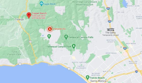
Your basic Google map. The three photos below were taken from Eagle Rock at top of map, looking south.
Last Friday 5-14-21 at ten in the evening, a fire started in Pacific Palisades. By Sunday it was over 1000 acres and burning northward over the hillside towards Topanga Canyon, a rugged rural area. As of this writing, Tuesday afternoon 5-18, the fire is being contained and evacuation alerts have been lifted.
Chris and Ruth Tosdevin, contributors of photos and sighting information to this blog over the past few years, live in Topanga Canyon. They missed our 5-16-21 Malibu Lagoon walk because of fire evacuations alerts. On Monday, May 17, they sent me this brief message in response to my inquiry about their safety. Prior to the pandemic, and for many years, Chris and Ruth led a monthly bird and nature walk from Trippet Ranch (part of Topanga State Park). They are intimately familiar with this area.

Before the fire. View from Trippet Ranch, Topanga State Park, standing east of Eagle Rock, southward towards the fire road/trail, over Pacific Palisades, out to Santa Monica Bay and to the northwest end of Santa Catalina Island, 40 miles away.

Santa Catalina Island.
So far…car packed and waiting for the word to leave—now 48hrs …what a drag! Great way to spend the weekend…situation remains dangerous and we are still on standby!
All depends on wind direction and the marine layer. 🤞
We missed birding this weekend and hope to catch up soon.
Very thoughtful of you to think of us.
Photos below show everything east of the fire road to eagle rock has gone—heartbreaking.
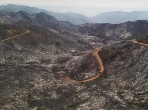
After the fire. Same view, May 17, 2021
So far it’s taken 110 firefighters and water drops from helicopters and airplanes, but the fires have been beaten back and evacuation warnings have been lifted.

After the fire. Same view as above, wider angle. Eagle Rock on right. May 17, 2021
Here’s the timeline from the Los Angeles Fire Dept. slightly shortened:
- Brush Fire 05-14-21 INC#1448 10:02PM. 1807 N Michael Ln; https://bit.ly/3yfAAUe; Pacific Palisades; Fire crews are working to access the remote area where a brush fire has been spotted. Relative humidity is high, with almost no wind. There are currently 60 LAFD firefighters assigned to the incident, as well as a brush response from LA County FD.
- Update Brush Fire 05-14-21 INC#1448 11:59PM. The fire is progressing slowly and has grown to approximately 10 acres.
- Update Brush Fire 05-15-21 INC#1448 01:04AM. LAFD has 72 firefighters on scene, with help from 4 LA County FD hand crews. Fire is approximately 10 acres in heavy brush and steep terrain; no wind and wet/cool conditions. No structures immediately threatened. Crews on standby in a local neighborhood for structure defense in case the conditions change unexpectedly. The fire is not advancing, but will be an extended process to extinguish because of the extremely remote location of the fire, where there are no road or hydrants in steep and rough terrain. LAFD Arson Investigators are on scene investigating.
- Update Brush Fire 05-15-21 INC#1448 06:30AM. Pacific Palisades. This incident initiated last night at 10PM and firefighters worked tirelessly through the night to hold it to approximately 15 acres (difficult to estimate at night due to fire location and it will be re-evaluated after morning briefings). No structures threatened, no evacuations in place and no injuries reported. The weather is cool and wet (with high humidity) and no-to-low winds which helped hold the fire in check within the ‘bowl’ it’s in. Last nights firefighting efforts were primarily from the air with LAFD helicopters making continuous water drops until 5AM, at which time the aircraft needed to undergo maintenance. Air Ops will resume operations today. Firefighters struggled to ascend the hillsides at night to lay in trunk lines (hand lines which serve as a water supply line to the firefighting lines) but due to the extremely steep terrain within the remote canyon and danger of trying to negotiate them in the dark, no existing safe escape routes and the lack of visibility to see the fire behavior (if a change in fire occurs, crews need to be able to move to safe ground prior to being put at risk), they were not able to put the trunk lines in place. A fresh set of fire engines and crews are rotating in this morning to continue the work.
- Update Brush Fire 05-15-21 INC#1448 04:15PM. Pacific Palisades. #PalisadesIC. There is a flare-up within the incident which is creating a large plume residents may see. The estimated size is 100 acres ‘slop over’ (meaning the edge of the fire crossed a control line as opposed to a ‘spot fire’ which is ahead of the fire body). Because the area of land under threat (to the west) is within the SRA (State Responsibility Area) which is a CAL-FIRE (state fire agency) jurisdiction (contracted to LA County Fire) this incident is expanding to a Unified Command with CAL-FIRE, LAFD and LA County Fire working together at incident command (for more information on SRA, https://bit.ly/3yc42dX). Fixed wing aircraft are approved for use as needed, determined by the Incident Command. Ventura Co Fire Dept is also provided a water dropping helicopter. There are no evacuation orders in place. The terrain is very steep and extremely difficult to navigate which hinders ground based firefighting operations. The bulk of the firefighting is air based. There are no injuries reported.
- Update Brush Fire 05-15-21 INC#1448 06:45PM. Pacific Palisades. This incident remains in a Unified Command with LAFD and LA County Fire. The estimated size is well over 200 acres in total. There are three burn areas (for a visual reference, two images will be available on @LAFDTalk on Twitter); the main fire, the original fire from last night and a small spot fire). There are no evacuation orders or structures threatened within the City of Los Angeles. For residents of the County of Los Angeles near this incident, follow @LACoFDPIO on Twitter for all information regarding threats or evacuations. The fire is burning at moderate rate due to the onshore winds. Dozers are working to improve access for firefighters on the ground but much of the area remains inaccessible. This is primarily an air based operation with both fixed wing and rotary working together. The state parks are closing trails in the area because it is unsafe for hikers but can not clear everyone due to the vast area involved. There are no injuries reported.
- Update Brush Fire 05-16-21 INC#1448 07:30AM. Pacific Palisades. Updated acreage and containment numbers are not yet available and will be provided as soon as possible. The weather remained cool and moist overnight which led to calmer fire activity. However, as it warms up today the conditions are expected to change as the vegetation in this area is very dry and has not burned in 50+ years. The onshore winds expected to pick up in the afternoon could push the fire in the NW direction and resources are in place for any structural defense required. The MANDATORY evacuation orders issued yesterday by Los Angeles County Fire Dept remain in effect (estimated to affect 1,000 people) and there is no change to the boundaries provided (follow @lacofdpio on Twitter for maps and orders). The fire cause is deemed to be a ‘suspicious start’ and it remains an open, active investigation (no further details). Helicopters continue to conduct water dropping operations while firefighters are on the ground in the difficult terrain, working to get handlines in place. An operational map of the fire perimeter as of 7AM this morning is available on @LAFDtalk on Twitter and @losangelesfiredepartment on Instagram. No structures have been damaged and no injuries reported. The command post relocated last night to Will Rogers State Beach with the media staging area located north of the lifeguard building. No further details.
- Cause Investigation Update: Brush Fire 05-16-21 INC#1448; 06:00PM. During the course of the investigation, LAFD Arson Investigators and LAPD have aggressively tracked down any and all potential leads. We did have one individual who was detained and released. However, we now have a 2nd individual that is being questioned. The active investigation into the cause of the Palisades fire continues.
- UPDATE Brush Fire 05-17-21 INC#1448 05:00PM. Pacific Palisades. Containment of the fire now stands at 23% while the acreage remains approximately 1325. There are no changes to the Evacuation Warning in the City of Los Angeles (map available at www.lafd.org/news). This has been a team effort across multiple agencies, both in the air and on the ground.
- Update Brush Fire 05-18-21 INC#1448 10:00AM. Containment of the fire now stands at 32% while the acreage has been more accurately updated to 1158 acres. There are no changes to the Evacuation Warning in the City of Los Angeles (map available at www.lafd.org/news). Information on the arrested arson suspect can also be found at lafd.org/news. This has been a team effort across multiple agencies, both in the air and on the ground.
- Update Brush Fire 05-18-21 INC#1448 01:00PM. The Evacuation Warning has been lifted for homes in the City of Los Angeles near the #PalisadesFire as of 1:00 PM today.
More updates, added later, follow below.
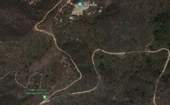
Google Satellite view of now-burnt portion of Topanga State Park.
Final Incident Update Brush Fire 05-26-21 INC#1448 6:00PM. As of 6:00PM today, the #PalisadesFire is 100% contained. Firefighters will remain on-scene patrolling to ensure all hotspots are fully extinguished. Fortunately, due to firefighter’s relentless efforts, no homes were damaged or destroyed, no civilians were injured and we were able to detain the arsonist within just 36 hours from the fire’s start. We would like to thank all of our partners and allied agencies who assisted in a successful conclusion of this incident. For information on how you can be prepared for this year’s fire season LAFD Wildfire Preparedness


