Free email delivery
Please sign up for email delivery in the subscription area to the right.
No salesman will call, at least not from us. Maybe from someone else.
The Masked Birders at Malibu Lagoon, 22 May, 2020

North across lagoon to PCH bridge, Serra Retreat Center on distant hill
(L. Johnson 5-22-20)
The sun was warm despite the scudding clouds, and a brisk breeze riffled the water. Typically for late May, there were few birds on the water, but the distant beach had a sizable flock of gulls, Brown Pelicans, and terns. People were few and mostly scattered, and the first we saw were three homeless people, two in animated maskless conversation and one resting at a picnic table.
We decided that birding qualifies as “active” rather than “passive” behavior – thus now legal on our SoCal beaches – so Lillian and I ventured to Malibu for the first time in three months. The parking lot was closed and the south side of Pacific Coast Highway was jammed with cars belonging to surfers, a surmise later supported by the numbers of surfers thrashing in the wind-blown waves. Plenty of parking was still available on the north side of PCH. It felt a little strange to be out and about and back at the lagoon, wearing mask and carrying scope. The Masked Birders ride again!

Eastward down the north channel, Adamson House in the distance
(L. Johnson 5-22-20)
Sure enough, duck and coots were few, and many of them were ducklings in various sizes. Eight Canada Geese rested on the west most sand island near the “Osprey snag.” They roused themselves a bit later, floated about for a few minutes, then flew off past Adamson House. On the long sand island paralleling the beach, just east of the large mixed flock, were two more adult geese, tending their troop of fluffy goslings. We counted four goslings, but there may have been an additional two. [Followup report.]
A solitary Western Grebe snoozed in mid-lagoon. Two pairs of American Coots were all that remained of February’s forty birds and October’s record count of 870.

SW across channel towards picnic corner and Malibu Colony
(L. Johnson 5-22-20)
Passerines were remarkably absent, except for Song Sparrows and House Finches in the brush, Barn Swallows in the sky, and one family of six Bushtits near the picnic corner, foraging in their usual rolling wave manner. We checked that corner for signs of Hooded Orioles, but found none. Neither were there any oriole nests visibly suspended from fronds of the nearby palms.

The sand spit points towards the sand island with bird flock
(L. Johnson 5-22-20)
The beach has become remarkably narrow in places, so narrow that it would be difficult to maintain social distancing should people plop themselves down on the sand and others tried to walk past them.

Searching for height markers on the tidal clock (L. Johnson 5-22-20)
The beach breech from lagoon to ocean is closed, as it always is by late May, and nearly all of the sea- and shorebirds were on a long and narrow island of sand, paralleling the beach. This gave them some safety from the encroachment of humans who – if they know “what’s what” (not all do) – stay out of the lagoon as the water can be polluted this time of year.
When the breach closes water collects in the lagoon; the water now is relatively high, about 7 feet above sea level. We couldn’t be certain about the exact elevation as the tiles indicating height along the Winter Ramp / Summer Clock are covered with mud and we couldn’t find them. Next time we go I’ll try to remember to take a trowel.

Looking west towards Malibu Colony & south portion of the lagoon
(L. Johnson 5-22-20)
We counted, recounted and re-re-re-recounted the few species there were. 94 Brown Pelicans was a fairly good number. The pelicans nest on the Channel Islands, particularly Anacapa, the smallest and closest of them, and the lagoon is a handy resting spot for them when they’re out and about searching for schools of fish. In addition to the 14 Double-crested Cormorants among the pelicans, there were another 10 in their two nesting trees in the shopping center across the street. Don’t park under them! – cormorants are famous for their guano-producing skills.

Not a lot of people on the beach (L. Johnson 5-22-20)
The terns in the flock were almost evenly divided between Caspian and Royal, and we were surprised to find not a single Elegant among them. The two Least Terns were quite busy diving on small lagoon fish although the breeze was riffling the water’s surface. The weather website later said the wind was 6mph, it seemed a bit stiffer than that to me. Traffic to and from Malibu was light, thanks to the pandemic, and what could have been a 2 ½ hour trip each way was under an hour.

A different angle on the sandy bird island, Adamson House and Malibu Pier
(L. Johnson 5-22-20)
We couldn’t do the usual six-consecutive-months census report as we missed March and April. Instead, you will find below a comparison of May trips for the past six years.
Birds new for the season: Least Tern, Caspian Tern, Black-crowned Night-Heron, Cooper’s Hawk, Barn Swallow. [Some of these species may have been present in March & April, but we weren’t there to see.]
Many thanks to photographer Lillian Johnson.
Our next three scheduled field trips: Who knows? Not I.
Our next program: We’ll have to wait and see.
NOTE: Our 10 a.m. Parent’s & Kids Birdwalk is canceled until further notice due to the near-impossibility of maintaining proper masked social distancing with parents and small children.
Links: Unusual birds at Malibu Lagoon
9/23/02 Aerial photo of Malibu Lagoon
Prior checklists:
2019: Jan-June, July-Dec
2018: Jan-June, July-Dec 2017: Jan-June, July-Dec
2016: Jan-June, July-Dec 2015: Jan-May, July-Dec
2014: Jan-July, July-Dec 2013: Jan-June, July-Dec
2012: Jan-June, July -Dec 2011: Jan-June, July-Dec
2010: Jan-June, July-Dec 2009: Jan-June, July-Dec.
The 10-year comparison summaries created during the Lagoon Reconfiguration Project period, despite numerous complaints, remain available on our Lagoon Project Bird Census Page. Very briefly summarized, the results unexpectedly indicate that avian species diversification and numbers improved slightly during the restoration period June’12-June’14.
[Chuck Almdale]
| Malibu Census | 2015 | 2016 | 2017 | 2018 | 2019 | 2020 |
| May 2015-2020 | 5/24 | 5/22 | 5/28 | 5/27 | 5/26 | 5/22 |
| Temperature | 59-70 | 61-66 | 63-68 | 61-66 | 57-59 | 61-65 |
| Tide Lo/Hi Height | L+0.54 | H+3.69 | L+1.32 | H+3.86 | L+0.66 | H+3.53 |
| Tide Time | 1139 | 1101 | 0627 | 0912 | 1040 | 1031 |
| Snow Goose | 3 | |||||
| (Black) Brant | 7 | 1 | ||||
| Canada Goose | 6 | 14 | ||||
| Gadwall | 22 | 8 | 15 | 12 | 13 | 34 |
| Mallard | 8 | 4 | 25 | 15 | 22 | 12 |
| Red-breasted Merganser | 1 | 4 | ||||
| Pied-billed Grebe | 1 | 1 | ||||
| Western Grebe | 1 | 1 | ||||
| Rock Pigeon | 9 | 1 | 13 | 3 | 18 | |
| Mourning Dove | 2 | 2 | 4 | 1 | 2 | |
| Anna’s Hummingbird | 2 | 1 | ||||
| Allen’s Hummingbird | 6 | 2 | 3 | 3 | 4 | |
| American Coot | 1 | 1 | 4 | 4 | ||
| Black-bellied Plover | 6 | 5 | 9 | 14 | ||
| Snowy Plover | 2 | 3 | ||||
| Killdeer | 6 | 6 | 14 | 4 | 4 | 2 |
| Whimbrel | 1 | 6 | 18 | |||
| Marbled Godwit | 30 | 4 | ||||
| Willet | 1 | 16 | 4 | 1 | ||
| Bonaparte’s Gull | 1 | 2 | ||||
| Heermann’s Gull | 45 | 8 | 1 | 2 | 4 | |
| Ring-billed Gull | 8 | 26 | 15 | |||
| Western Gull | 135 | 23 | 45 | 112 | 125 | 210 |
| California Gull | 6 | 3 | ||||
| Glaucous-winged Gull | 1 | 3 | ||||
| Least Tern | 3 | 9 | 12 | 2 | ||
| Caspian Tern | 11 | 9 | 4 | 11 | 13 | 60 |
| Forster’s Tern | 2 | |||||
| Royal Tern | 2 | 48 | 2 | 2 | 55 | |
| Elegant Tern | 85 | 10 | 45 | 130 | 165 | |
| Pacific Loon | 1 | |||||
| Brandt’s Cormorant | 1 | 1 | 1 | |||
| Double-crested Cormorant | 55 | 7 | 12 | 15 | 27 | 14 |
| Pelagic Cormorant | 4 | 2 | ||||
| Brown Pelican | 70 | 14 | 18 | 68 | 108 | 94 |
| Great Blue Heron | 2 | 2 | 3 | 1 | ||
| Great Egret | 5 | 1 | 3 | 2 | ||
| Snowy Egret | 4 | 2 | 2 | 4 | 8 | 3 |
| Green Heron | 1 | |||||
| Black-crowned Night-Heron | 1 | 1 | 1 | |||
| Turkey Vulture | 4 | |||||
| Osprey | 1 | 1 | ||||
| Cooper’s Hawk | 1 | |||||
| Red-tailed Hawk | 1 | |||||
| Peregrine Falcon | 1 | |||||
| Nanday Parakeet | 3 | |||||
| Black Phoebe | 2 | 1 | 5 | 5 | ||
| California Scrub-Jay | 2 | |||||
| American Crow | 5 | 4 | 5 | 2 | 6 | 2 |
| Violet-green Swallow | 2 | 1 | ||||
| Rough-winged Swallow | 6 | 6 | 3 | 5 | ||
| Cliff Swallow | 10 | 4 | 3 | 8 | 6 | |
| Barn Swallow | 12 | 4 | 10 | 10 | 14 | 10 |
| Bushtit | 2 | 2 | 20 | 1 | 6 | |
| Bewick’s Wren | 1 | |||||
| Western Bluebird | 1 | |||||
| American Robin | 1 | |||||
| Northern Mockingbird | 3 | 2 | 8 | 2 | 3 | 2 |
| European Starling | 3 | 2 | 12 | 12 | 9 | |
| House Sparrow | 3 | |||||
| House Finch | 20 | 7 | 30 | 5 | 8 | 16 |
| Spotted Towhee | 1 | |||||
| California Towhee | 2 | 2 | 1 | |||
| Song Sparrow | 9 | 2 | 12 | 5 | 5 | 12 |
| Hooded Oriole | 3 | 2 | ||||
| Red-winged Blackbird | 2 | 4 | ||||
| Brewer’s Blackbird | 2 | 12 | ||||
| Great-tailed Grackle | 3 | 3 | 4 | 4 | ||
| Common Yellowthroat | 1 | 4 | ||||
| Totals by Type | 5/24 | 5/22 | 5/28 | 5/27 | 5/26 | 5/22 |
| Waterfowl | 37 | 14 | 47 | 27 | 41 | 60 |
| Water Birds – Other | 134 | 22 | 31 | 88 | 138 | 113 |
| Herons, Egrets & Ibis | 11 | 5 | 6 | 9 | 11 | 4 |
| Quail & Raptors | 1 | 1 | 0 | 5 | 0 | 2 |
| Shorebirds | 8 | 28 | 21 | 56 | 4 | 39 |
| Gulls & Terns | 294 | 127 | 97 | 269 | 334 | 334 |
| Doves | 11 | 3 | 17 | 4 | 20 | 0 |
| Other Non-Passerines | 8 | 2 | 3 | 1 | 6 | 4 |
| Passerines | 86 | 60 | 92 | 66 | 63 | 62 |
| Totals Birds | 590 | 262 | 314 | 525 | 617 | 618 |
| Year | 2015 | 2016 | 2017 | 2018 | 2019 | 2020 |
| Total Species | 5/24 | 5/22 | 5/28 | 5/27 | 5/26 | 5/22 |
| Waterfowl | 3 | 4 | 4 | 2 | 3 | 3 |
| Water Birds – Other | 8 | 3 | 3 | 4 | 4 | 4 |
| Herons, Egrets & Ibis | 3 | 3 | 3 | 4 | 3 | 2 |
| Quail & Raptors | 1 | 1 | 0 | 2 | 0 | 2 |
| Shorebirds | 3 | 3 | 3 | 6 | 1 | 5 |
| Gulls & Terns | 9 | 7 | 4 | 8 | 7 | 6 |
| Doves | 2 | 2 | 2 | 2 | 2 | 0 |
| Other Non-Passerines | 2 | 1 | 1 | 1 | 2 | 1 |
| Passerines | 17 | 17 | 10 | 12 | 11 | 9 |
| Totals Species – 69 | 48 | 41 | 30 | 41 | 33 | 32 |
Report from Tromsø, Norway, 70° North
Subscribers to the BirdChat ListServe are very familiar with the always interesting slice-of-Nordic-life postings of Wim Vader. Wim loves watching birds and sharing his observations, and his messages from the far north are always lovely to read, as you will see below.
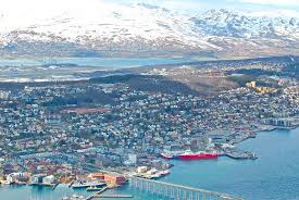
Tromsø, Norway
He tells his own story better than I and if you enjoy it, subscribe to the BirdChat ListServe. It’s nationwide, free, always has interesting and informative postings such as Wim’s, and you can consolidate postings from them to one email per day. [Chuck Almdale]
Date: Tue, 26 May 2020
From: Willem Jan Marinus Vader <wim.vader@UIT.NO>
Subject: Birding in the dark – Tromsø in winter
Since a few days, we have got back the midnight sun again in Tromsø, N. Norway, where I have lived since 1973. But spring is late this year: our garden is still 3/4 snow-covered, the birches are still bare and I have not yet heard the Willow Warbler, our most numerous song bird.
As several people has asked me how birds and birding are in winter in Tromsø, when it is mostly dark, I’ll give an impression here. Please let me know, if I mail too often these days; being more or less isolated gives one more time for such activities.
Tromsø, is at c 70* N, and with c 75,000 inhabitants the largest town in N. Scandinavia. Because of the Gulf Stream, we have a forest of mainly birch trees (and pines in the inland), instead of ice or bleak tundra, as everywhere else at this latitude. The town is situated on the island of Tromsøya, and the sounds surrounding the island form the sill of the large Balsfjord. Between us and the open sea there is the large and high island of Kvaløya, so that by road it is c 50 km to the outer coast. The island itself is not very high, maybe 100 m, but the surrounding hills on the mainland and Kvaløya reach 1200 m. My house is at the south end of the island, at c 45 m o.s.l., and close to a remnant birch forest with much planted spruce, Folkeparken; I walk through Folkeparken on my way to Tromsø Museum, where I worked for 40 years and still have a desk and do research on my specialty, the amphipod crustaceans. I am now 83.
Being so far north, we have a long winter, and snow half the year (snow depth, now, 26 May, is 80 cm(!), but this is a late year), but because of the open water around, the winters are not very severe, with temperatures rarely falling below – 17*C (in the inland it easily can get – 40*C). All the cars here have summer and winter wheels, and they shift to winter wheels, usually with studded tires, in October, shifting back in May. I also use ‘brodder’ under my shoes for most of winter; they are especially useful in the increasingly frequent periods of Atlantic depressions with milder temperatures, leading to very slippery and icy roads and paths (Without these periods, we would have had almost 4 m of snow this winter!).
Another major factor between our winters and yours is the absence of daylight in mid winter here; the sun is not visible from late November to late January. With the reflecting snow on the ground it is usually possible to walk the unlighted paths in Folkeparken during the day, but birding in winter is no easy task: the icy roads are hard to drive (in fact, I don’t drive at all in winter anymore) and there is very little daylight.
So how do the birds cope with all this? Most simply by doing what a popular song here says: ‘The birds come to their senses and fly south’: they leave us in autumn and come back in spring. Some, like the Arctic Terns, almost overdo this by flying all the way to the Antarctic, and swallows, cuckoos and Willow Warblers winter in S. Africa, but many species do not migrate further than South or even Western Europe. The species that do stay here in winter I have divided into several categories:
1. Seabirds. For them there are no problems of ice and snow, as the water remains open. On the other hand, the dark may well be a problem for species such as terns that hunt by sight, making it impossible to remain here in winter. We won’t talk about them further, just remark that in winter we have here several species that nest even further north, and only can be found here in winter. Good examples are the King Eider and the Yellow-billed Loon (White-billed Diver for some).
2. Shore birds. There is often ice on the shores in winter, and many if the intertidal invertebrates also migrate to deeper water in winter, so the shore is a difficult environment in that season, and most shore birds leave us. A few of the hardier gulls, such as the Herring Gull and the Great Black-backed Gull can be seen here all year (But it looks like as if ours migrate and the winter birds are breeders from NW Russia). And there is a single shorebird that apparently has overcome all these problems; that is the roly-poly Purple Sandpiper, that seems impervious to the cold and always able to find the periwinkles they feed on.
3. Freshwater birds. All freshwater here freezes over for many months on end, so these birds all have to leave, unless they can change over to the open shore, as the Grey Herons and some few Mallards do. Another small exception is our national bird, the Dipper, where part of the population survives the winter up here at some rapids, that never freeze completely over.
4. Ground feeders. Just as with the freshwater birds, they all have to leave in winter, as the ground is snow covered for months on end. A few Woodcocks try to winter on the outer islands, but they often are found dead.
5. Bulk feeders. In this category the grouse are most important. Willow Grouse and Ptarmigan feed on willow buds and shoots, Black Grouse on birch, and the large Capercaillie (more an inland bird here) on pine needles. We have few woodpeckers here, but some winters there is an influx from the east of Great Spotted Woodpeckers, and they feed mostly on pine seeds in winter.
6. Insect feeders. The large majority of these of course migrate south in winter, or switch to other food, as do the tits, the woodpeckers and to a certain degree also the Tree Creeper (which also habitually robs the caches that the Willow Tits make in autumn). Strangely enough the smallest of them all, the Goldcrest, seems to stay with insect food all winter, and in severe winters many die.
7. Fruit feeders. Northern Norway is a country very rich in wild berries, feasted on by both birds, mammals and man. And many of them tolerate frost well. However, most of them grow on or near the ground and are therefore very hard to get to in winter. An exception is the Rowan (Mountain Ash, Sorbus aucuparia), a tree that yields large amounts of orange edible berries (which make a good jam!). The berry crop varies a lot from year to year, but some years we have a bumper crop, and in those years the thrushes (Fieldfare and Redwing) that otherwise fly south in October, linger till January and feast on the rowan berries. Another fruit eater, that arrives in time for the rowan feast, is the beautiful Bohemian Waxwing, and in top years there may be many hundreds of them even in my garden. Some years also Pine Grosbeak join in the feast, as tame here as they are everywhere.
8. ‘Seed eaters *feeder birds’. Lots of people here feed the birds all winter, and for most of them sun flower seeds are the favourite food offered. The most common birds at the feeders are Great Tits and the last years also the newcomer Blue Tit, as well as here and there pairs of Willow Tits. The latter hoards food in autumn, and is therefore less dependent on kind people than Great and Blue Tits, which do not hoard. Greenfinches, also a newcomer here far north (still absent when I came here in 1973, but now almost the most numerous winter bird), greedily feed at the feeders, and have a tendency to try to monopolize them, and there are often also Bullfinches, these large, calm and beautiful finches, that here north have even taken over for European Robins on the Christmas cards. Where there are House Sparrows, they of course also participate, but this species is quite patchily distributed here and also very resident: there is a small colony at a house 50 m down the road, but I never see them in our garden. Many of these feeders are close to lighted windows and at such places one can find feeding birds virtually at any hour of day or night. Clearly, there is too little daylight to allow the birds to confine their activities to the 2-3 hours of twilight.
9. Omnivores. Here the crows come in, and they are the most conspicuous land birds in winter Tromsø. Our garden, as very many, has a resident pairs of Magpies (not the Aussie ones, but the long-tailed black and white crow of that name), and one of hooded Crows, while in winter Northern Ravens also venture into town, although they are much more circumspect. The magpies often succeed to raid the feeders, with some acrobatics (as our many feral pigeons now and down also manage), while the crows don’t even try. Also the large gulls are omnivorous, but in winter they mostly keep to the shores.
10. Predators. Somewhat surprisingly, given the lack of ‘good hunting light’ there are quite a number of predators around, mostly hunters of birds rather than small mammals. White-tailed Sea Eagles are common, but they scavenge almost as much as catch their own prey in winter. More active hunters are the Sparrow Hawk, often causing panic at the feeders, and the Northern Goshawk, mostly a winter visitor here. I have also once or twice seen a Gyrfalcon, usually a hunter of grouse, in town, no doubt looking for a meal among our town flock of feral pigeons, as so much else here ‘the northernmost in the world.’
If this sounds like a lot of birds, I have given the wrong impression. In reality land birds, except for the crows, the greenfinches and the tits, are very thin on the ground here in winter, and a walk through town will usually not get you into the double digits of bird species numbers this time a year, even at mid day. Nevertheless, we are very fond of our winter birds: they add colour and movement to an otherwise largely black and white landscape. A very beautiful and often spectacular landscape, by the way. Come and see for yourself, when such will once again be feasible!
Wim Vader, Tromsø, Norway
Building the Perfect Squirrel-Proof Bird Feeder
“Squirrels were stealing my bird seed so I solved the problem with mechanical engineering 🙂“
Former NASA engineer – with seven years working on the Curiosity Rover under his belt – Mark Rober became Covid-trapped at home, takes up birdwatching, but has a problem with squirrels gobbling up all the birdseed. Sound familiar? But Mark uses his mechanical engineering skills to develop a unique method to deal with his wily adversaries.
This is the guy who previously developed the “glitter-stinkbomb package” to punish his local porch pirates. [Chuck Almdale]
Reprise 20: Los Angeles County Birding Spots
Editor’s Note: Number twenty and the final entry in our tenth anniversary tour is another never-a-blog (i.e. never emailed to readers). We announced it on several birding chatlines shortly after this collection of seven pages was put on the blogsite in January, 2013, but rarely since then. The 30,000 visits it has had since then are the result of people using search engines for topics like “los angeles birding” or “birds near LAX.”
I initially gathered the information in the 1990’s with the intention of creating a county “birding trails” map such as those previously produced by several other California counties. Suddenly (it seems in retrospect) computers came along and the idea of spending thousands of dollars to print glossy folders and then trying to distribute or sell them seemed downright silly. Put it on the web and let people find and download it at no cost (except time) to us or them.
Well, the idea was great, but it does take time and creating all these maps is a pain in the @$$. But, year after year, this is our most visited blog or page(s). So I guess it was worth it. This posting contains snippets from the much larger work. [Chuck Almdale]
Fall is my favorite season in Los Angeles,
watching the birds change color and fall from the trees.
David Letterman
[NOTE: Last significant update 8/8/15. Suggestions & comments welcome. Maps are at the beginning of each area; if one doesn’t appear, refresh the page. Links & maps sometimes balky to open. Print desired text selections by ‘drag-copy-paste’ into a word-processing document. Copy maps by following the map’s link to Google Maps, re-size view as desired and use the Google Map print function. Species search this page with your web browser Edit>Find function.]
MAP OF LOS ANGELES COUNTY BIRDING REGIONS
Blue – Antelope Valley Green – San Gabriel Mountains
Orange – San Fernando Valley Violet – Northern Santa Monica Bay
Yellow – Central & Eastern L.A. County Aqua – South Bay & Palos Verdes Penn.
Airplane – LAX International Airport Anchor – Harbor for boat to see Island Scrub-Jay
TABLE OF CONTENTS
1. At LAX Airport with only a few hours to a day for birding?
2. Santa Cruz Island for the Island Scrub-Jay
3. Finding Parrots & Parakeets
4. Doves and Other Oddities
5. More Los Angeles County Information useful to birders
On-line species search; Bird-finding guide; Email bird chat lines; Audubon chapter web sites; Links to maps, Lists or Audubon chapters of nearby counties; Weather & seasons; Driving tips; Pedestrian tips; Food tips.
6. Los Angeles County Birding Locations – 81 sites:
Note: In this blog, clicking on the six following links takes you to the blog site.
A – Antelope Valley: Western Valley, Eastern Valley – 20 sites
B – San Gabriel Mountains area – 13 sites
C – San Fernando Valley – 12 sites
D – Northern Santa Monica Bay – 11 sites
E – Central & Eastern Los Angeles County – 15 sites
F – South Bay and Palos Verdes Peninsula area – 10 sites
The information presented here is designed primarily for new birders and birders visiting the area. The information was supplied by members of the L.A. County Audubon chapters listed below and compiled by Chuck Almdale of Santa Monica Bay Audubon.
********************
1. AT LAX AIRPORT WITH ONLY A FEW HOURS OR A DAY FOR BIRDING?
You’d do best by visiting both a seaside area and/or a mixed riparian-chaparral habitat. Large grassy parks usually don’t have much variety. We suggest the following locations. You could spend 1-5 hours at any of these locales, or bird them all in 5 hours, and easily find 50 – 80 species (depending on the time of year). These areas are quite safe, which unfortunately can’t be said about every birding locality in LA County.
These sites are:
SW of LAX: Dockweiler Beach, El Segundo Library Park
NW of LAX: Ballona Creek & Jetties, Ballona Freshwater Marsh
NE of LAX: Playa Vista Central Park, Holy Cross Cemetery, Kenneth Hahn/Baldwin Hills Recreation Area
Farther NW: Temescal Gateway Park
D9a. BALLONA CREEK, MARINA DEL REY HARBOR ENTRANCE, PLAYA DEL REY LAGOON, BALLONA WETLANDS
Highlights: Seabirds, cormorants, ducks, grebes, loons, raptors, waders, gulls, migrants. Brown Pelican, nesting Great Blue Heron, Black Oystercatcher, Wandering Tattler, Black Turnstone & Surfbird in winter & migration. Large-billed Savannah Sparrow (except high tide) is an occasional winter resident on the fishing jetty. Least Terns nest May-August on Venice Beach north of north MDR jetty. Anna’s and Allen’s Hummingbirds in the flowers, California Towhees in the dune scrub, warblers and Bushtits in the brush alongside the south jetty. Local parakeets are either Rose-ringed or Yellow-chevroned.
Google Map link & directions from LAX
By Cab: About 10 minutes from LAX to Playa del Rey. Have the cab drop you off at the north end of Pacific. From here you can walk the jetties and beaches, check Del Rey Lagoon (which you just passed), walk back into town and call a cab from any of the restaurants which also have better food than the airport.
Del Rey Lagoon: On your right as you head north up Pacific Ave. It has many local species, esp. ducks, gulls and shorebirds. Black-crowned Night Herons and various parrot species often roost in trees by the shaded parking lot.
Habitat: Open sea, rocky shore, beach, marshland, pond.
Best Season/time: Sept. through Apr. All day. Fishermen can crowd jetties on weekends.
Monthly Birdwalk: 3rd Sunday, 8 AM, led by Los Angeles Audubon Society.
Facilities: Paved road, flush toilets (southeast corner of Playa del Rey lagoon), picnic tables, phone.
Parking: Fee beachside lots. Free parking on street and next to Del Rey Lagoon.
Disabled Access: Paved bike path & jetty sidewalks.
General Location: On the beach north of LA airport, 18 miles WSW of downtown LA.
Directions: East out of the airport, keep right to take exit onto Sepulveda Blvd. north. Move to left, in about 1/4 mile bear left onto Lincoln Blvd/Westchester Parkway. Continue on Lincoln as it bends right (north and continue about 2 miles to Jefferson Blvd. As you turn left onto Jefferson, the Ballona Fresh Water Marsh will be on your left (see below). Continue 0.6 mile to Culver Blvd. Bear left and continue 1.0 miles straight through the stop lights (don’t follow curve to south) until you reach Pacific Ave., the last street before the beach. Turn right (north). About 1/10 mile, park in the lot next to the lagoon or on the street. From here it is a short walk farther north on Pacific to the Ballona Channel. Walk along south side of Ballona Creek to right (east), or north side bike path left or right.
Suggestions: Check lagoon for various ducks and geese, cross footbridge at end of Pacific Ave. to the South Jetty of the MDR entrance and go left, all the way to the end if you want. Rocky shore birds like the south side of this jetty, or the north side of the jetty across the creek. Scan outer jetty for oystercatchers, cormorants and tattlers. Loons, grebes and scoters can be anywhere. Return inland. Along this jetty, up to 500 yards inland of the footbridge, many shorebirds, gulls and terns relax. Ducks are in the creek or main boat channel, as is the occasional alcid. Back across the footbridge, walk left past apartment houses and warning fences to stroll along the south side of the creek, from where you can look over the fence into the wetlands. Keep an eye open for Rose-ringed Parakeets, the common Psittacids in Playa del Rey, which have nested in palm tree holes near the small shopping on Culver Blvd. Back at the beach, you may find gulls, terns and skimmers resting on the sand south of Ballona Creek. Large rafts of grebes and sea ducks winter offshore. These rafts continue southward down Dockweiler Beach (see D10 below); careful scoping often turn up Black & White-winged Scoter, Red-necked and Clark’s Grebe. Snowy Plovers winter on Dockweiler Beach near the trailer park in front of the Hyperion Sewage Plant. Many gulls, including Mew, gather in winter seaward of the fee parking lot across from Hyperion.
To return to LAX airport:
Back down Pacific to Culver Blvd., left on Culver 1 mile to Jefferson Blvd., angle right ½ mile to Lincoln Blvd., right on Lincoln 2 ½ miles to Sepulveda Blvd. (Lincoln takes a curve to the left when it reaches the north edge of the airport), right on Sepulveda ¼ mile to airport entrance on right or ¼ mile further to Century Blvd., where a right turn takes you to LAX or a left leads to most of the airport area hotels.
********************************
If you have your own car, here’s a nearby freshwater and field habitat:
D9b BALLONA FRESH WATER MARSH
Highlights: Ducks, raptors, Moorhen & Sora, waders, gulls, ground & bush birds; Marsh Wren, Least Bittern (hard to see), Great-tailed Grackle. Total list is over 150 species. Across Jefferson Blvd. and up the hill, just below the entrance to Loyola Marymount University (LMU), there is a walking path leading along the cliff. Parking at LMU is free on Sundays, probably also on Saturdays (ask the guard at the entrance kiosk.) A good selection of local birds and occasional rarities (e.g. Painted Bunting) are available.
Habitat: Fresh water marsh, reed beds, ponds, open fields.
Best Season/time: Sept through Apr. All day.
Monthly Birdwalk: None
Facilities: Port-a-potties
Parking: No lot. Free on south side of Jefferson Blvd. alongside marsh.
Disabled Access: Level crushed granite and dirt path.
General Location: Intersection of Lincoln & Jefferson Blvds, 1 mile east of Playa del Rey, 17 miles WSW of downtown LA.
Google Map Playa del Rey to Ballona FWM and back to LAX Link & Directions
Directions from intersection #10 & 405 Fwys: #405 south 4 miles, #90 west 2 miles, Culver Blvd southwest 2 miles to end (don’t follow curve to south), north (right) on Pacific to end & park wherever available. Walk along south side of Ballona Creek to right, or north side bike path left or right.
Riparian Path to the East: Along the base of the cliff to the east (across Lincoln Blvd.) there is a path alongside a narrow riparian area that leads all the way to another site, Playa Vista Central Park. Return To Top
********************************
If you have more time, and want some woodland and chaparral birds:
D11. KENNETH HAHN / BALDWIN HILLS RECREATION AREA
Highlights: Local birds, ducks in pond, migrants in season, wintering vagrants.
Habitat: Lake, trees, brush, plantings.
Best Season/time: Winter & Spring. Morning, early PM.
Monthly Birdwalk: 3rd Saturday, 8am, turn left after gate into 1st lot and park; led by Los Angeles Audubon Society.
Facilities: Paved roads, bike paths, flush toilets, phone, water, picnic tables. This park is under development with many facilities including camping to be added, but some undeveloped areas will remain. It is the closest park to Los Angeles Airport, so if you have only a few hours to spare, you could take a taxi and pick up a few common SoCal birds.
Parking: Free on weekdays, fee on weekends.
Disabled Access: Paved roads and sidewalks.
General Location: 8 miles WSW of downtown LA in Culver City in the Baldwin Hills, 7 miles NNE of LAX Airport.
MapQuest link & directions from LAX: http://mapq.st/foFMer
Directions: From intersection #10 & 405 Fwys, #10 east 3 miles to La Cienega Blvd exit, right (south) 2 miles to Ken Hahn Park exit, then left into park, pay at entrance gate. Return To Top
********************************
The beach closest to the airport:
D10. DOCKWEILER BEACH
Highlights: Sea ducks, loons, grebes, pelicans, sandpipers, gulls, terns, Mew Gull seaward of parking lot south of Hyperion Water Reclamation Plant. Black & White-winged Scoters and Clark’s Grebe in small numbers during winter in the large offshore rafts.
Habitat: Sandy beach, a few rock jetties, ocean.
Best Season/time: Fall – Spring. Bikepath can be busy on weekends.
Facilities: Parking lot, flush toilet, restaurant nearby.
Parking: Fee parking lot.
Disabled Access: Paved around parking lot. Paved bike path.
General Location: About 2 miles west of LAX terminals.
Google Map to Location
Directions: At the airport exit, turn south onto Sepulveda Blvd./Pacific Coast Hwy. In .7 miles, turn right (west) onto Fwy #110. Continue west 2 miles to the ocean as the fwy. ends and becomes Imperial Hwy. Left on Vista del Mar and 0.6 mile to a large pay parking lot on the ocean side. There are stairs down to the beach at the NW corner of this lot, next to a restroom.
Suggestions: Go for a walk on the beach. Scope is very useful (almost necessary) to scan the offshore flocks.
********************************
Four other sites near LAX are on the blog page.
*********************************************
*********************************************
2. SANTA CRUZ ISLAND – ISLAND SCRUB-JAY
Highlights: The Island Scrub-Jay is endemic to Santa Cruz Island.
How to get there: Take Island Packers to Santa Cruz Is. – Prisoner’s Harbor
Suggestion: Read the Island Packers website and book ahead. Dress for cooler weather on the ocean than on land. Have seasickness medicine at hand. The channel can be rough.
Which Trip?: Santa Cruz Island trip docking at Prisoner’s Harbor on island’s north side.
Why There?: The birds are easily seen. If you go to Scorpion Anchorage on the east end of Santa Cruz Island, the birds are far less common and you will probably have to take a rugged hike of several hours to fine one.
Best Season/time: All year, although seas tend to be rougher in the winter.
Cost: Day trip to Prisoner’s Harbor is currently $59 (adult).
Island Packers Boat Dock: 1691 Spinnaker Drive, Ventura, CA. 93001-4367 Phone: 805-642-6573
Mapquest Map of Ventura Harbor Boat Dock
Mapquest Directions from LAX Airport
Travel Time: 75 minutes in good traffic. Best to allow 2 hours.
Alternate Pacific Coast Hwy Route: More scenic but slower. Malibu Lagoon enroute, as well as several birdy canyons.
*********************************************
*********************************************
3. FINDING PARROTS AND PARAKEETS
Parrots are easiest to find at their roosts which they leave around dawn and return to a bit before sunset. The rest of the day they spend foraging and/or resting. Foraging sites are blooming/fruiting/seeding trees and thus change frequently. The western San Gabriel Valley communities host the most species and largest concentrations. You may see Amazona parrots over the #210 Fwy in Pasadena, Monrovia & Arcadia; Black-hooded Parakeets are also in the area. Sierra Madre hosts many Amazona and Aratinga species. Listed below are the most reliable locations.
Link to Parrot Map This link opens a separate window for the same map.
Temple City has the most reliable roosts, but these roosts do shift around a bit.
1. Temple City Library Park – Arrive 1-2 hours before dark and watch for parrot flocks flying overhead to the nighttime roosts. This helps you to locate them. Parrots often land and rest in trees in the park or nearby, so check around.
Directions: From intersection #10 & #405 Fwys: 9.3 miles east to #110 Fwy north, 2.2 miles to #10 Fwy east, 7.7 miles east to Rosemead Blvd. north, 2.4 miles north to E. Las Tunas Dr., right (east) 1 mile to the park on left side of street.
Three other sites on on the blog page.
South Pasadena also has roosts and foraging psittacids, primarily Mitered Parakeet, but also Amazona species including Yellow-headed Parrot.
2. Larger area around South Pasadena Library:
Birds may forage and/or roost in the general residential area west of Fair Oaks Ave. & north of Monterey Rd. (intersection is 1 block S and 5 blocks E of the library). Drive around, looking and listening. Roost may include: Red-crowned Parrot, Mitred Parakeet, Yellow-headed Parrot, Blue-fronted Parrots.
Five other sites are on the blog page.
Sites for the other three common parakeets are listed by bird.
Yellow-chevroned Parakeet
Best found in the southwest San Gabriel Valley and from the Los Angeles Civic Center west through urban parks such as MacArthur Park and Lafayette Park, all the way to the seashore in Marina del Rey, Venice and Santa Monica. They fly around a lot, calling noisily as they do, sounding like children screaming in the distance. They especially favor the Silk-floss Kapok tree which has large seed pods and spikes on the trunk.
2. Huntington Gardens – See also Site E4.
Directions: From intersection #10 & 405 Fwys, #10 east 9.5 miles, #110 northeast 11.5 miles, when Fwy becomes Arroyo Parkway continue ½ mile to California Blvd, right (east) on California 1.3 miles to Allen Ave, right (south) & cross Orlando Rd. into the grounds.
Five other sites are on the blog page.
Nanday (or Black-hooded) Parakeet
This bird favors the wooded canyons of the southern and western side of the Santa Monica Mountains from Beverly Hills to Sycamore Canyon in SW Ventura County next to the ocean. They occur in Pasadena, Sierra Madre and Arcadia but we don’t have reliable locations. They nest in holes, especially in sycamore trees. In the right area, you can see them resting in trees, feeding, or flying noisily overhead. (Mitred Parakeets and some Amazona species are also in the same areas.)
1. Franklin Canyon – See also site Site D8.
Directions: From intersection #10 & 405 Fwys, #405 north 1.5 miles to Santa Monica Blvd exit, right (east) 3 miles to Coldwater Canyon Drive, then left onto Beverly Drive, (north) 2.5 miles to Franklin Canyon Dr, right 2 miles to reservoir.
Five other sites are on the blog page.
Rose-ringed Parakeet
Far less common than the other species, Rose-ringed are fairly reliable in Playa del Rey, where they may be the most commonly seen psittacid. They have nested in palm tree cavities in and near the small shopping center on Culver Blvd. & Vista del Mar, but they could be anywhere around the palm-laden residential area and del Rey Lagoon. See Ballona Creek & Playa del Rey – Site D9a.
*********************************************
*********************************************
4. DOVES AND OTHER ODDITIES
Of the 10 dove species possible in L.A. County, not all are equally likely. We start with the easy comments.
Rock Pigeon Columba livia: Widespread in urban & suburban areas, just like in the rest of the USA. Much less common in unsettled areas.
Mourning Dove Zenaida macroura: Possible anywhere, but more common in suburbs, parks and wild areas than in treeless urban areas. They have developed the peculiar habit of nesting in hanging flower pots, probably because they’re too lazy to build a real nest.
Eurasian Collared-Dove Streptopelia decaocto: Can be found almost anywhere, but more common in suburbs & rural areas than in treeless urban landscapes or in mountains. More common in eastern and southeastern portions of county than in western. Just about any park listed in the central, eastern and southern areas below, and many that aren’t, will have some.
Ringed Turtle-Dove Streptopelia risoria: Forget it. There used to be a significant population 20-30 years ago in downtown L.A., especially around Olvera St., but that’s gone. No one counts them anymore. Too many people letting loose flocks of doves/pigeons whenever someone gets married or dies to consider any OrTD you might see as a countable bird.
Ruddy Ground-Dove Columbina talpacoti: Forget it. One was seen in La Canada (area around C12 below) in 2006 for about a week. That’s it. Go to the Imperial Valley where they are reported in the Calipatria area, near the intersection of W. Eddins & Sperry Rds., about 1.5 miles west of Hwy #111.
SPOTTED DOVE (LOWER) AND INCA DOVE (UPPER) SITES
Spotted Dove Streptopelia chinensis: Introduced many decades ago, and verging on abundant in city and suburbs until 15-20 years, they have almost disappeared for unknown reasons. Several locations are suggested.
Gonzales Park in Compton may have two birds. Directions: From intersection #10 & 405 Fwys, #405 south 8 miles, #105 east 7.9 miles, exit 10 Wilmington Ave, turn right onto S. Wilmington Ave., 1.6 miles south to W. Rosecrans Ave, 0.2 mile to Bobby Parham Ave/N Dwight Ave, turn right, N 1 block to W. Cressey St, turn right, then left into the small park.
Two other sites are on the blog page.
Inca Dove Columbina inca: Far more common in the Imperial Valley in many places like Finney Lake. A small population at Lake Los Angeles (sorry, there’s no lake there) in the eastern Antelope Valley appears to be an outlier group of this common Mexican bird, rather than an escapee population. They are most recently found near #40955 172nd Street East. They have previously been reported between 167th to 169th St., between Mossdale and Valeport Aves.; in a lot across from 16819 Mossdale Ave. west of 169th, the intersection of 169th St E and Mossdale Ave.; a front yard on 168th St East just north of Valeport Ave.
Washington Park in S.E. Los Angeles. A small population of seven Inca Doves, discovered Feb 6,2014, continues, perhaps dwindling. Whether they are escapees or wild birds is unknown. North of Watts: Maie Ave. between Firestone Blvd and 92nd St. Check the south end of the park, soccer practice yard, swimming pool, maintenance yard near 91st St., the (possibly abandoned) plant nursery across the street, or the high-tension wire towers at the nursery’s west end.
One other site is on the blog page.
Band-tailed Pigeon Patagioenas fasciata: Fairly common in the canyons of the Santa Monica and San Gabriel Mtns, but they get down into the surburban areas and even downtown L.A. in the Civic Center. They’re very quiet when perched or flying. Acorns are one of their primary foods, which is why they like the oak-filled riparian canyons, but they are also be found in the mountains among the conifers. You rarely see the band in the tail on a perching bird, but the white mark on the nape is fairly easy to spot, the iridescent patch below it a bit less obvious.
Fourteen sites are on the blog page.
WHITE-WINGED DOVE SITES
White-winged Dove Zenaida asiatica: They are far more common in the southeastern Calif. deserts of Imperial and Riverside Counties, but there seem to be a few residents, or at least visitors that show up repeatedly in a few locations.
Point Dume: Several are regularly seen mostly around Point Dume State Beach Park (about 1 mile from Site D1 Zuma Beach) at the top of the cliff, which is also a good spot to look for passing seabirds and whales. Eurasian Collared-Doves and Mourning Doves area also in the area. White-winged Doves move around the area, and are also seen on Cliffside Dr. east of Grasswood Ave. and at intersection of Fernhill and Boniface Drives. Directions: From intersection 10 & 405 Fwys, #10 Fwy west 3.2 miles, continue on Pacific Coast Hwy west 18.7 miles; left on Zumirez Drive and continue on Wildlife Rd for 0.3 mile, turn right on Fernhill Dr., in 0.7 mile turn right on Cliffside Dr, continue 0.5 mile to parking area.
Five other sites are on the blog page.
COMMON GROUND-DOVE SITES
Common Ground-Dove Columbina passerina: Widely scattered and irregularly seen in LA County.
Powder Canyon trailhead in La Habra Heights seems to be the most reliable spot. They are seen and heard near the parking lot and on the ground along the access road. These birds often sit in trees when not feeding. Look for very small, tailless Mourning Doves. Directions: From intersection #10 & 405 Fwys, #10 east 12 miles, #60 Fwy east 19.3 miles to exit 19 Fullerton Rd, turn right, keep right at the fork and follow signs 2.0 miles for Fullerton Rd S. and merge onto Fullerton Rd, turn right to stay on Fullerton, access road to trailhead should be about 0.2 mile on the right.
Three other sites are on the blog page.
Red-whiskered Bulbul and Scaly-breasted Munia are official California Checklist birds. Bishops are not.
RED-WHISKERED BULBUL SITES
Red-whiskered Bulbul Pycnonotus jocosus: This Asian species, found from India to Hong Kong, became locally established around 1968 in from Pasadena east to Monrovia. They are on the Federal Injurious Species list as crop pests, so it’s illegal to import them or own them as cage birds. Eradication efforts were made during the 70’s. They are very well established. The surest place to see them is at the Arboretum where there is a very robust population.
Los Angeles County Arboretum, see Site E5. Probably at least several dozen birds. They love berries; ask at the entrance gate where they might be.
Five other sites are on the blog page.
ORANGE BISHOP & SCALY-BREASTED MUNIA (NUTMEG MANNIKIN) SITES
Orange Bishop Euplectes franciscanus: This southern African grassland species has been around for a couple of decades. Generally restricted to unused grassy areas. I’ve seen them only in grasses and low leafy plants, but people have reported them in reeds. The males develop their bright orange breeding plumage in late August. In basic plumage, they look like females which look like odd sparrows.
Nutmeg Mannikin Lonchura punctulata: Any habitat hosting bishops may, and often does, have mannikins as well.
San Gabriel River in El Monte: Orange Bishops and Scaly-breasted Munias possible anywhere between Valley Blvd. at the north to Thienes Ave in the south. Directions: From intersection #10 & 405 Fwys, #10 east 12.7 miles, #60 Fwy east 10.8 miles to exit 11 Durfee Ave, left on Durfee and left again onto Peck Rd, 0.3 mile and continuing 0.2 mile when it changes back to Durfee Ave, right on Thienes Ave and 0.4 mile to end.
Six other sites are on the blog page.
*********************************************
*********************************************
5. MORE LOS ANGELES COUNTY INFORMATION USEFUL TO BIRDERS
As of July 2006, Los Angeles County had over 490 species of birds, not counting the parrots and various uncommon escaped or feral species. This breaks down into over 270 non-passerines and over 210 passerines, a higher species count than 80% of the other 49 states. Among causes of this high diversity: major land and sea migration routes pass through, many habitats and elevations, many species winter here, and the warm weather of the southern United States.
Search for Any Species on any of the Local Bird Chat Forums:
You can do a “message search” for any particular species. On LA County Birds https://groups.io/g/LACoBirds/ scroll down to the “Message History” area. Click on a month and poke around. Within any month, you can “Search” for text and it will search all months. You don’t have to be a member.
Local Bird-finding Guide Book:
A Birder’s Guide to Southern California $25.95 ABA/Schram, 2007. Covers area from Mexico & Arizona borders north to San Luis Obispo & Mono Counties. It may be hard or impossible to find this book.
American Birding Association has off-loaded their bird-finding guides to Buteo Books: American Birding Association (800-634-7736, https://www.buteobooks.com/category/ABABG.html
See also Amazon.com or direct link to the book.
Nationwide Birding Lists Digests
The Birding List Digest: https://www.facebook.com/pages/The-Birding-Lists-Digest/171007826255380 Shows you ALL the postings on bird-chat lines. Maybe.
ABA Birding News: http://birding.aba.org/ gives access to blog postings of over 140 different geographical areas and topics, including 20 birding areas for California alone.
eBird: https://ebird.org/home Search on hot spots, months, species, etc. If you don’t know how to use this now-world-wide resource, join it and learn how.
Subscribe to Local Email Bird Chat Lines.
Despite the existence of eBird, these are still very useful. Send an email by clicking a link below; put “subscribe” without the quotes on the subject line. The chat line will automatically send you a confirmation email to which you must respond to successfully sign up. If your email system/program has a spam blocker, you must first tell it to let their confirmation through. Google groups.io + the county to find their website. Most bird chatlines around the country migrated to Groups.IO a few years ago when Yahoo quit handling such low/no-profit groups.
Los Angeles County: LACoBirds+subscribe@groups.io
San Diego & Imperial Counties: SanDiegoRegionBirding+subscribe@groups.io
Orange County: OrangeCountyBirding+subscribe@groups.io
San Bernardino, Riverside & Imperial Counties: inlandcountybirds+subscribe@groups.io
Ventura County: venturacobirding+subscribe@groups.io
Santa Barbara County: main+subscribe@sbcobirding.groups.io
Kern County: kerncobirding+subscribe@groups.io
Central Valley: centralvalleybirds+subscribe@groups.io
General California bird chit-chat: CALBIRDS+subscribe@groups.io
L.A. County Audubon Chapter Web Sites:
All Chapters have bird walks open to the public.
The Links below will take you to their local bird-finding tips & Trips page, if any.
Conejo Valley Audubon Bird Finding Tips (Ventura Cnty & SW LA Cnty)
El Dorado Audubon
Los Angeles Audubon
Palos Verdes Audubon
Pasadena Audubon Bird Finding Tips
Pomona Valley Audubon Bird Finding Tips
San Fernando Valley Audubon Bird Finding Tips
Santa Monica Bay Audubon Calendar
Whittier Audubon
Links to Maps, Lists or Audubon Chapters of Other Counties and Areas
California Redwoods Birding Trail
Eastern Sierra Birding Trail – from Mono Lake Committee & Eastern Sierra Audubon
Fresno Audubon Birding Maps (Fresno County)
Joe Morlan’s California County Birding Page
Klamath Basin Birding Trail
Kern County (Nature Ali’s list)
Kern, Tulare, Kings & Inyo Counties – 67 Sites Birding map (by Nature Ali)
Morro Coast Bird Finding Guides – 5 guides San Luis Obispo County
National Audubon Society – Birding in California
San Bernardino Valley Audubon Field Trips (San Bernardino County)
San Diego Audubon Local Birding Sites (San Diego County)
Santa Barbara Audubon Activities & Field Trips(Santa Barbara County)
Sea & Sage Audubon Bird Finding Tips (Orange County)
Tom Benson’s Maps & Links (from San Bernardino Audubon)
Tulare Audubon Society (Tulare & Kings Counties)
Ventura Audubon Society Local Birding Sites (Ventura County)
Weather & Seasons:
We have four seasons, roughly:
Fog: April – June, sometimes into July, mostly along the coast.
Smog: April – November. We have a natural temperature inversion layer which holds the smog low. If you can see the mountains, no matter how poorly, the smog isn’t too bad. If you can’t see them, it’s a bad smog day.
Fire: June – December, especially August to November.
Mudslide (aka rainy season): November – April, especially January – March. If the fires were bad, so too will be the mudslides.
Mid-to-late summer is slow for birding in the SoCal lowlands, but can be good in the cooler mountains and at the really hot (110-120°F) Salton Sea. Winters can be cool, plunging way, way down into the 40’s near the ocean, often with a strong wind. Inland valley summers are usually over 90° and deserts usually over 100°; winters can be cool (high of 45 – 50°) and windy, but rarely snowy. Mountain mornings are always cool, and the mountains freeze and snow up in the winter, closing some roads. Winter rainstorms can be fierce (mostly in El Nino years) and mudslides can close canyon roads. Humidity is generally very low. It’s a desert here!
Driving Tips:
Have a very good idea how to get to your destination before you set out. If possible, get a map(s) that cover the areas you’ll be in. AAA has them for members. This is a very large city. Know which direction (N-S-E-W) you want to go, as the road signs often refer to distant towns – often hundreds of miles away – you’ve never heard of. Many streets are many miles long (Western Blvd. is reportedly the longest straight city street in America), and many names are re-used in various locales, so your GPS might lead you astray unless you know exactly where you’re going.
Turning right on a red light, after cross traffic has passed and pedestrians have crossed, is usually legal unless posted otherwise.
Always always always yield to pedestrians crossing at an intersection, whether or not a crosswalk is painted on the pavement. The police run sting operations in order to catch and ticket drivers who don’t stop for pedestrians. Stay stopped until the pedestrian reaches the opposite sidewalk. Signal all lane changes. Be courteous and thoughtful.
Please don’t drive and talk or text on a cell phone at the same time, even if it does seem like everyone around you is doing it. It’s a great way to get into an accident or miss your street or exit and wind up in Arizona.
Never throw anything burning out the window: major local forest fires, destroyed houses and loss of life start this way.
Links to SIGALERT, GO511, HERE, LA LOCAL, and LA DOT (city streets).
Pedestrian Tips:
Please stay on the sidewalk while waiting to cross the street. Standing in the street while waiting for the light to change immediately brands you as an out-of-towner. Drivers trying to turn right won’t expect you to be in the street and may run you over. Pedestrians, in a crosswalk (and any intersection is considered to have a crosswalk whether or not the lines are actually painted on the road), always have the right-of-way unless the traffic has a green light. Native and/or courteous drivers observe this law; unfortunately many drivers from out-of-town do not, so taking this legal right for granted can be a dangerous matter.
Food Tips:
Great food everywhere. The dumpy little burger, burrito, felafel, Chinese, Thai, Indian or whatnot hole-in-the-wall places usually have better-tasting and more interesting food than the well-known fast food chains. We have the best chiliburgers in the world! (Your mission, should you choose to accept it, is to eat one without making a mess all over yourself.) All eateries must prominently display their food safety rating; A is the highest rating. Don’t eat anywhere rated C or lower.
Editor’s Note: The following is a portion of one of our six area pages and includes four of the eleven birding sites.
[NOTE: Suggestions & comments welcome. Maps are at the beginning of each area; if one doesn’t appear, refresh the page. Print desired text selections by ‘drag-copy-past’ into a word-processing document. Copy maps by following the map’s link to Google Maps, re-size view as desired and use the Google Map print function. Species search this page with your web browser Edit>Find function.]
MAP OF LOS ANGELES COUNTY BIRDING REGIONS
Blue – Antelope Valley Green – San Gabriel Mountains
Orange – San Fernando Valley Violet – Northern Santa Monica Bay
Yellow – Central & Eastern L.A. County Aqua – South Bay & Palos Verdes Penn.
Airplane – LAX International Airport Anchor – Harbor for boat to see Island Scrub-Jay
Region D – Northern Santa Monica Bay
D1. ZUMA CANYON & BEACH
Highlights: Various typical riparian and chaparral birds. Woodpeckers, possible Canyon Wren up the creek. Migrants in spring. Shorebirds, gulls, terns on beach, Loons, grebes, sea ducks in water. Roosting site of 100+ Snowy Plover flock Oct-Apr.
Habitat: Chaparral, woods, brush, fields, permanent stream. Many wildflowers in spring.
Best Season/time: Fall, winter, Spring. Morning and early PM. Can be hot in summer.
Monthly Birdwalk: None
Facilities: Paved road to sand beach, flush toilets on beach, pit toilet at trailhead, dirt trail.
Parking: Free, but limited at trailhead. Large beach pay parking lot, free on PCH.
Disabled Access: Paved beach parking lot. Dirt trail flat at beginning.
General Location: 33 miles W of downtown LA, just off Pacific Coast Hwy 7 miles west of Malibu.
Directions: From intersection 10 & 405 Fwys, #10 Fwy west 4 miles, continue on Pacific Coast Hwy west 19.5 miles; right at light and uphill to canyon trailhead, beach is on left.
D2. SOLSTICE CANYON
Highlights: Riparian and chaparral birds. Woodpeckers, possible Canyon Wren past end of paved trail. Migrants in spring.
Habitat: Chaparral, woods, brush, fields, permanent stream. Many wildflowers in spring.
Best Season/time: Fall, winter, Spring. Morning and early PM. Can be hot in summer.
Monthly Birdwalk: None
Facilities: Paved road, flush toilets, picnic tables.
Parking: Free, but limited. No parking available outside park.
Disabled Access: Long paved driveway (now trail) to ruined house. Uphill sometimes steep.
General Location: 29 miles W of downtown LA, just off Pacific Coast Hwy 3 miles west of Malibu.
Directions: From intersection 10 & 405 Fwys, #10 Fwy west 4 miles, continue on Pacific Coast Hwy west 15.7 miles, right (north) on Solstice Cyn. Rd and .7 mile to park entrance on left.
D3. MALIBU CREEK STATE PARK
Highlights: Raptors, migrants, chaparral & riparian birds. Winter Red-breasted Sapsucker, also Lewis’ Woodpecker occasional.
Habitat: Riparian, chaparral, fields, hills, creeks.
Best Season/time: Sept through May. Morning. Can be hot in summer.
Monthly Birdwalk: 3rd Sunday 8:00am by San Fernando Valley Audubon Society.
Facilities: Paved road, camping, flush toilets, port-a-potties, interpretive center, picnic tables, phone, rock climbing, miles of trails, old M*A*S*H filming site.
Parking: Entrance fee.
Disabled Access: Paved parking areas & unused side road; hard packed dirt paths.
General Location: 34 miles WNW of downtown LA, between Pacific Coast Hwy and #101 Fwy.
Directions: From intersection #10 & 405 Fwys, #10 Fwy west 4 miles to Pacific Coast Hwy, continue approx.13 miles west, right (north) on Malibu Canyon Rd (becomes Las Virgenes Rd), approx. 7 miles north to park entrance on left.
D4. MALIBU LAGOON, SURFRIDER BEACH & ADAMSON HOUSE
Highlights: Offshore, shorebirds and waterfowl fall, winter, spring. 60+ species common in winter. Allen’s Hummingbird, Sora, wintering Snowy Plover & (often) Peregrine Falcon.
Habitat: Ocean, shore, salicornia coastal marsh, creek, brush & trees.
Best Season/time: Fall, winter, spring. All day; beach can be crowded in afternoon.
Monthly Birdwalk: 4th Sunday 8:30 am by Santa Monica Bay Audubon Society
Facilities: Paved road, pit toilets, interpretive center, picnic tables, phone, beach, surfing.
Parking: Fee lot, or free nearby street parking.
Disabled Access: Limited paved sidewalks; hard packed dirt paths.
Adamson House: Across the bridge from the lagoon parking lot. Trees & flowers. Paved sidewalks Free entrance to grounds.
General Location: 26 miles W of downtown LA in central Malibu.
Directions: From intersection #10 & 405 Fwys, #10 Fwy west 4 miles to Pacific Coast Hwy, continue approx. 12 miles west to Malibu Pier, continue past the bridge to park entrance on left or park on PCH or Cross Creek Rd.
[Chuck Almdale]
Lockdown and movement restrictions imposed due to the coronavirus pandemic are having a positive effect on Qatar’s wildlife

From Al Jazeera website
Link to article on: AlJazeera.com
by Stefanie Dekker Tuesday, May 26, 2020
Make sure you watch the 3:37 video
[Posted by Chuck Almdale]


